
This is an outline of the themes, topics, fields, and resources developed or under development for the course principles of radiation astronomy or related courses involving any of various radiation astronomies. Titles or synonyms for titles, where applicable, are on the right.
Notations
Universals
"Incorporating tracking studies into clinical trials of cell-based therapy at the earliest stage can provide proof of mechanism of the therapy and permit evaluation of the many contributory variables, even on a patient-by-patient basis."[1]
"[B]iochemical markers [may be used] for early proof of mechanism"[2]
"One early “proof of mechanism” study of farglitazar, a non-TZD PPARγ agonist, assessed 24-h insulin and glucose profiles in a double-blind, randomized, placebo-controlled study in patients with type 2 diabetes."[3]
Astronomy
Provide a general example from the astronomical literature about the lecture field.
Radiation
Provide a general example from the astronomical literature about the lecture field and uses of radiation.
Planets
Provide a general example from the astronomical literature about the lecture field that may be from planetary astronomy or may result from the object being radiated into an orbit within a light of another object.
Minerals as sources
Theory for the field
Universals for radiation astronomy
Charge in the universe
General radiation topics
Radiation bigger than atoms or nuclei
Acoustical astronomy actually uses radiation astronomy to study large matter waves, oscillations, or vibrations.
Particulates like atoms and nuclei
Electromagnetic radiation
States of matter
Rocky objects
Astrochemistry
Atmospherics
Special techniques
Astronomical objects
History
Include specific examples that have been used to apply a date in the past to an object, whether astronomic, geologic, or archeologic.
Def.
- "the time and geology dated before the Phanerozoic"[4] or
- the "eon (or supereon) and rock formations dated before 541.0±1.0 million years ago, coinciding with the first appearance of the fossils of hard-shelled animals"[4]
is called the precambrian.
Def.
- "the geologic eon from about 4,600 to 3,800 million years ago; marked by the formation of the solar system, a stable Earth-Moon orbit and the first rocks"[5] or
- the "eon before 4,000 Ma"[5]
is called the Hadean.
Def.
- "a geologic era within the Archaean eon from about 4600 to 3600 million years ago; the first single-celled life began at this time"[6] or
- the "era from 4,000 Ma to 3,600 Ma"[6]
is called the Eoarchean.
Archaean is an alternate spelling of Archean.
Def.
- "the geologic eon from about 3,800 to 2,500 million years ago; comprises the Eoarchean, Paleoarchean, Mesoarchean and Neoarchean eras; marked by an atmosphere with little oxygen, the formation of the first continents and oceans and the emergence of simple life"[7] or
- the "eon from 2,500 Ma to 4,000 Ma"[7]
is called the Archaean, or Archean.
Def.
- "a geologic era within the Archaean eon from about 3600 to 3200 million years ago; the first aerobic bacteria appeared at this time"[8] or
- the "era from 3,600 Ma to 3,200 Ma"[8]
is called the paleoarchean.
Def.
- "a geologic era within the Archaean eon from about 3200 to 2800 million years ago; stromatolites have existed from this time"[9] or
- the "era from 3,200 Ma to 2,800 Ma"[9]
is called the Mesoarchean.
The Pongola glaciation is dated "at 2.9 Ga".[10]
Def.
- "a geologic era within the Archaean eon from about 2800 to 2500 million years ago"[11] or
- the "era from 2,800 Ma to 2,500 Ma"[11]
is called the Neoarchean.
Def. "older than the lowest rocks which contain organic remains"[12] is called the hypozoic.
Def.
- destitute "of any vestige of organic life, or at least of animal life",[13]
- anterior "to the existence of animal life",[13] or
- formed "when there was no animal life on the globe"[13]
is called the azoic.
Def. the "eon from 2,500 Ma to 541.0±1.0 Ma, the beginning of the Phanerozoic, marked by the build up of oxygen in the atmosphere and the emergence of primitive multicellular life"[14] is called the Proterozoic.
The "Makganyene glaciation begins some time after 2.32 Ga and ends at 2.22 Ga, the three Huronian glaciations predate the Makganyene snowball."[10]
The Huronian Ice Age is known "mainly from Canada and the United States in North America, where dated rocks range from 2500 to 2100 million years old."[15]
Def. the "era from 2,500 Ma to 1,600 Ma, marked by a dramatic increase in atmospheric oxygen"[16] is called the Paleoproterozoic.
Def. "a geologic era within the Proterozoic eon; comprises the Calymmian, Ectasian and Stennian periods from about 1600 to 900 million years ago, when the Rodinia supercontinent was formed"[17] is called the Mesoproterozoic.
Def. "a geologic era within the Proterozoic eon; comprises the Tonian, Cryogenian and Ediacaran periods from about 1000 to 544 million years ago, when algae and sponges flourished"[18] is called the Neoproterozoic.
The Cryogenian Ice Age, or the Stuartian-Varangian Ice Age, a "Late Proterozoic ice age was apparently the greatest of all. Glacial strata are known from all modern continents (except Antarctica) with an overall time range of about 950 to 600 million years old.
The Phanerozoic eon includes the Paleozoic, Mesozoic, and Cenozoic. It lasted from 542.0 ± 1.0 Mb2k to the present.
The Paleozoic era spanned 542.0 ± 1.0 to 251.0 ± 0.7 Mb2k.
The Cambrian lasted from 542.0 ± 1.0 to 488.3 ± 1.7 Mb2k.
The Ordovician lasted from 488.3 ± 1.7 to 443.7 ± 1.5 Mb2k.
The "Andean-Saharan [occurred] between 450 and 420 Ma […] did not achieve a global extent."[19]
The Silurian spanned 443.7 ± 1.5 to 416.0 ± 2.8 Mb2k.
The Devonian spanned 416.0 ± 2.8 to 359.2 ± 2.5 Mb2k.
The "Karoo [occurred] between 360 and 260 Ma [but] did not achieve a global extent."[19]
The Carboniferous began 359.2 ± 2.5 Mb2k and ended 299.0 ± 0.8 Mb2k.
The Mississippian lasted from 359.2 ± 2.5 to 318.1 ± 1.3 Mb2k.
The Pennsylvanian lasted from 318.1 ± 1.3 to 299.0 ± 0.8 Mb2k.
The Permian lasted from 299.0 ± 0.8 to 251.0 ± 0.4 Mb2k.
The Permian/Triassic boundary occurs at 248.2 ± 4.8 Ma (million years ago).[20]
The Permian/Triassic boundary occurs at 248.2 ± 4.8 Ma (million years ago).[20]
The Triassic/Jurassic boundary occurs at 205.7 ± 4.0 Ma (million years ago).[20]
The Permian/Triassic boundary occurs at 248.2 ± 4.8 Ma (million years ago).[20]
The Jurassic is a geologic period and system that extends from about 199.6±0.6 Ma (million years ago) to 145.5±4 Ma.
The Triassic/Jurassic boundary occurs at 205.7 ± 4.0 Ma (million years ago).[20]
"The Cretaceous period is the third and final period in the Mesozoic Era. It began 145.5 million years ago after the Jurassic Period and ended 65.5 million years ago, before the Paleogene Period of the Cenozoic Era."[21]
The Cretaceous/Cenozoic boundary occurs at 65.0 ± 0.1 Ma (million years ago).[20]
The Tertiary Period extends from 65.5 ± 0.3 to 2.588 x 10⁶ b2k.
The Paleogene Period extends from 65.5 ± 0.3 to 23.03 ± 0.05 x 10⁶ b2k.
The Paleocene dates from 65.5 ± 0.3 x 10⁶ to 55.8 ± 0.2 x 10⁶ b2k.
The Eocene dates from 55.8 ± 0.2 x 10⁶ to 33.9 ± 0.1 x 10⁶ b2k.
The Oligocene dates from 33.9 ± 0.1 x 10⁶ to 23.03 x 10⁶ b2k.
"This late Cenozoic ice age began at least 30 million years ago in Antarctica; it expanded to Arctic regions of southern Alaska, Greenland, Iceland, and Svalbard between 10 and 3 million years ago. Glaciers and ice sheets in these areas have been relatively stable, more-or-less permanent features during the past few million years."[15]
The Neogene dates from 23.03 x 10⁶ to 2.58 x 10⁶ b2k.
The Miocene dates from 23.03 x 10⁶ to 5.332 x 10⁶ b2k.
The prehistory period dates from around 7 x 10⁶ b2k to about 7,000 b2k.
The Pliocene ranges from 5.332 x 10⁶ to 2.588 x 10⁶ b2k.

"The boundary-stratotype of the stage is located in the Eraclea Minoa section on the southern coast of Sicily (Italy), at the base of the Trubi Formation. The age of the Zanclean and Pliocene GSSP at the base of the stage is 5.33 Ma in the orbitally calibrated time scale, and lies within the lowermost reversed episode of the Gilbert Chron (C3n.4r), below the Thvera normal subchron."[22]
MIS Boundary TG5/TG6 is at 5315 ka.[23]
MIS Boundary TG4/TG5 is at 5301 ka.[23]
MIS Boundary TG3/TG4 is at 5289 ka.[23]
MIS Boundary TG2/TG3 is at 5266 ka.[23]
MIS Boundary TG1/TG2 is at 5241 ka.[23]
MIS Boundary T8/TG1 is at 5188 ka.[23]
MIS Boundary T7/T8 is at 5165 ka.[23]
MIS Boundary T6/T7 is at 5116 ka.[23]
MIS Boundary T5/T6 is at 5094 ka.[23]
MIS Boundary T4/T5 is at 5070 ka.[23]
MIS Boundary T3/T4 is at 5038 ka.[23]
MIS Boundary T2/T3 is at 5016 ka.[23]
MIS Boundary T1/T2 is at 5002 ka.[23]
MIS Boundary ST4/T1 is at 4985 ka.[23]
MIS Boundary ST3/ST4 is at 4976 ka.[23]
MIS Boundary ST2/ST3 is at 4952.5 ka.[23]
MIS Boundary ST1/ST2 is at 4931 ka.[23]
MIS Boundary Si6/ST1 is at 4904 ka.[23]
MIS Boundary Si5/Si6 is at 4883 ka.[23]
MIS Boundary Si4/Si5 is at 4860 ka.[23]
MIS Boundary Si3/Si4 is at 4840 ka.[23]
MIS Boundary Si2/Si3 is at 4821 ka.[23]
MIS Boundary Si1/Si2 is at 4807 ka.[23]
MIS Boundary NS6/Si1 is at 4778 ka.[23]
MIS Boundary NS5/NS6 is at 4766 ka.[23]
MIS Boundary NS4/NS5 is at 4737 ka.[23]
MIS Boundary NS3/NS4 is at 4722.5 ka.[23]
MIS Boundary NS2/NS3 is at 4702.5 ka.[23]
MIS Boundary NS1/NS2 is at 4684 ka.[23]
MIS Boundary N10/NS1 is at 4658 ka.[23]
MIS Boundary N9/N10 is at 4648 ka.[23]
MIS Boundary N8/N9 is at 4622 ka.[23]
MIS Boundary N7/N8 is at 4603 ka.[23]
MIS Boundary N6/N7 is at 45887 ka.[23]
MIS Boundary N5/N6 is at 4570 ka.[23]
MIS Boundary N4/N5 is at 4538 ka.[23]
MIS Boundary N3/N4 is at 4523 ka.[23]
MIS Boundary N2/N3 is at 4508 ka.[23]
MIS Boundary N1/N2 is at 4487 ka.[23]
MIS Boundary CN8/N1 is at 4457 ka.[23]
MIS Boundary CN7/CN8 is at 4446 ka.[23]
MIS Boundary CN6/CN7 is at 4420 ka.[23]
MIS Boundary CN5/CN6 is at 4395 ka.[23]
MIS Boundary CN4/CN5 is at 4371 ka.[23]
MIS Boundary CN3/CN4 is at 4356 ka.[23]
MIS Boundary CN2/CN3 is at 4335 ka.[23]
MIS Boundary CN1/CN2 is at 4327 ka.[23]
MIS Boundary Co4/CN1 is at 4303 ka.[23]
MIS Boundary Co3/Co4 is at 4286 ka.[23]
MIS Boundary Co2/Co3 is at 4259 ka.[23]
MIS Boundary Co1/Co2 is at 4232 ka.[23]
MIS Boundary Gi28/Co1 is at 4211 ka.[23]
MIS Boundary Gi27/Gi28 is at 4192 ka.[23]
MIS Boundary Gi26/Gi27 is at 4175 ka.[23]
MIS Boundary Gi25/Gi26 is at 4146 ka.[23]
MIS Boundary Gi24/Gi25 is at 4098 ka.[23]
MIS Boundary Gi23/Gi24 is at 4085 ka.[23]
MIS Boundary Gi22/Gi23 is at 4048 ka.[23]
MIS Boundary Gi21/Gi22 is at 4029 ka.[23]
MIS Boundary Gi20/Gi21 is at 4007 ka.[23]
MIS Boundary Gi19/Gi20 is at 3978 ka.[23]
MIS Boundary Gi18/Gi19 is at 3952 ka.[23]
MIS Boundary Gi17/Gi18 is at 3939 ka.[23]
MIS Boundary Gi16/Gi17 is at 3923 ka.[23]
MIS Boundary Gi15/Gi16 is at 3912 ka.[23]
MIS Boundary Gi14/Gi15 is at 3879 ka.[23]
MIS Boundary Gi13/Gi14 is at 3862 ka.[23]
MIS Boundary Gi12/Gi13 is at 3835 ka.[23]
MIS Boundary Gi11/Gi12 is at 3822 ka.[23]
MIS Boundary Gi10/Gi11 is at 3798 ka.[23]
MIS Boundary Gi9/Gi10 is at 3768 ka.[23]
MIS Boundary Gi8/Gi9 is at 3752 ka.[23]
MIS Boundary Gi7/Gi8 is at 3742 ka.[23]
MIS Boundary Gi6/Gi7 is at 3719 ka.[23]
MIS Boundary Gi5/Gi6 is at 3705 ka.[23]
MIS Boundary Gi4/Gi5 is at 3676 ka.[23]
MIS Boundary Gi3/Gi4 is at 3660 ka.[23]
MIS Boundary Gi2/Gi3 is at 3637 ka.[23]
MIS Boundary Gi1/Gi2 is at 3619 ka.[23]
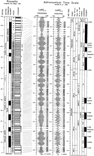
The magnetic field reversal to the present geomagnetic poles (Matuyama chron) occurred at 2,590,000 yr BP.
"The base of the beige marl bed of the small-scale carbonate cycle 77 (sensu Hilgen, 1991b) is the approved base of the Piacenzian Stage (that is the Lower Pliocene-Middle Pliocene boundary). It corresponds to precessional excursion 347 as numbered from the present with an astrochronological age estimate of 3.600 Ma (Lourens et al., 1996a)."[24]
MIS Boundary MG12/Gi1 is at 3592 ka.[23]
MIS Boundary MG11/MG12 is at 3578 ka.[23]
MIS Boundary MG10/MG11 is at 3566 ka.[23]
MIS Boundary MG9/MG10 is at 3546 ka.[23]
MIS Boundary MG8/MG9 is at 3532 ka.[23]
MIS Boundary MG7/MG8 is at 3517 ka.[23]
MIS Boundary MG6/MG7 is at 3471 ka.[23]
MIS Boundary MG5/MG6 is at 3444 ka.[23]
MIS Boundary MG4/MG5 is at 3387 ka.[23]
MIS Boundary MG3/MG4 is at 3372 ka.[23]
MIS Boundary MG2/MG3 is at 3347 ka.[23]
MIS Boundary MG1/MG2 is at 3332 ka.[23]
MIS Boundary M2/MG1 is at 3312 ka.[23]
MIS Boundary M1/M2 is at 3264 ka.[23]
MIS Boundary KM6/M1 is at 3238 ka.[23]
MIS Boundary KM5/KM6 is at 3212 ka.[23]
MIS Boundary KM4/KM5 is at 3184 ka.[23]
MIS Boundary KM3/KM4 is at 3167 ka.[23]
MIS Boundary KM2/KM3 is at 3150 ka.[23]
MIS Boundary KM1/KM2 is at 3119 ka.[23]
MIS Boundary K2/KM1 is at 3097 ka.[23]
MIS Boundary K1/K2 is at 3087 ka.[23]
MIS Boundary G22/K1 is at 3055 ka.[23]
MIS Boundary G21/G22 is at 3039 ka.[23]
MIS Boundary G20/6G21 is at 3025 ka.[23]
MIS Boundary G19/G20 is at 2999 ka.[23]
MIS Boundary G18/G19 is at 2982.5 ka.[23]
MIS Boundary G17/G18 is at 2966 ka.[23]
MIS Boundary G16/G17 is at 2937 ka.[23]
MIS Boundary G15/G16 is at 2913 ka.[23]
MIS Boundary G14/G15 is at 2893 ka.[23]
MIS Boundary G13/G14 is at 2876 ka.[23]
MIS Boundary G12/G13 is at 2858 ka.[23]
MIS Boundary G11/G12 is at 2838 ka.[23]
MIS Boundary G10/G11 is at 2820 ka.[23]
MIS Boundary G9/G10 is at 2798 ka.[23]
MIS Boundary G8/G9 is at 2777 ka.[23]
MIS Boundary G7/G8 is at 2759 ka.[23]
MIS Boundary G6/G7 is at 2730 ka.[23]
MIS Boundary G5/G6 is at 2704 ka.[23]
MIS Boundary G4/G5 is at 2690 ka.[23]
MIS Boundary G3/G4 is at 2681 ka.[23]
MIS Boundary G2/G3 is at 2652 ka.[23]
MIS Boundary G1/G2 is at 2638 ka.[23]
MIS Boundary 104/G1 is at 2614 ka.[23]
The paleolithic period dates from around 2.6 x 10⁶ b2k to the end of the Pleistocene around 12,000 b2k.
MIS Boundary 103/105 is at 2595 ka.[23]
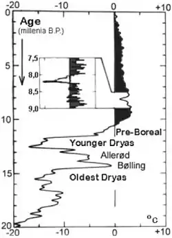
The "whole change elapsed just opposite the course of events that characterized the great glacial oscillations with sudden warming followed by slow cooling. Therefore, the two phenomena hardly have the same cause."[25]
The Pleistocene dates from 2.588 x 10⁶ to 11,700 b2k.
Some number of N tills occurred during the Olduvai subchron.[26]
The magnetic field reversal to the present geomagnetic poles (Olduvai subchron) occurred at 2,000,000 yr BP.
The oldest till group, R2 tills, consists of till units with a reversed polarity and >77% of sedimentary clasts. Low amounts of expandable clays, substantial amounts of kaolinite, and the absence of chlorite characterize the clay mineralogy of R2 tills. The mineralogy of the silt fraction of R2 tills is rich in quartz and depleted in calcite, dolomite, and feldspar. This till group includes a till unit that underlies the 2.0-Ma Huckleberry Ridge ash, thus indicating deposition sometime between ~2.5 Ma (onset of Northern Hemisphere glaciations) (Mix et al., 1995) and 2.0 Ma.[26]
The magnetic field reversal to the present geomagnetic poles (Reunion subchron) and back occurred at 2,080,000 yr BP.
The magnetic field reversal to the present geomagnetic poles (Reunion subchron) and back occurred at 2,140,000 yr BP.
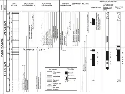
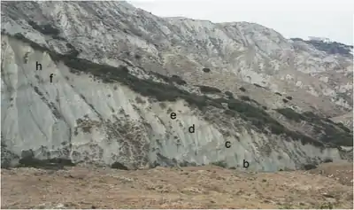
"The base of the Quaternary System [shown in the image on the right] is defined by the Global Stratotype Section and Point (GSSP) of the Gelasian Stage at Monte San Nicola in Sicily, Italy, currently dated at 2.58 Ma."[27]
"The astrochronological age of sapropel MPRS 250 (mid-point), corresponding to precessional cycle 250 from the present, is 2.588 Ma (Lourens et al., 1996), which can be assumed as the age of the boundary."[28]
MIS Boundary 102/103 is at 2575 ka.[23]
MIS Boundary 101/102 is at 2554 ka.[23]
MIS Boundary 100/101 is at 2540 ka.[23]
MIS Boundary 99/100 is at 2510 ka.[23]
MIS Boundary 98/99 is at 2494 ka.[23]
MIS Boundary 97/98 is at 2477 ka.[23]
MIS Boundary 96/97 is at 2452 ka.[23]
MIS Boundary 95/96 is at 2427 ka.[23]
MIS Boundary 94/95 is at 2407 ka.[23]
MIS Boundary 93/94 is at 2387 ka.[23]
MIS Boundary 92/93 is at 2373 ka.[23]
MIS Boundary 91/92 is at 2350 ka.[23]
MIS Boundary 90/91 is at 2333 ka.[23]
MIS Boundary 89/90 is at 2309 ka.[23]
MIS Boundary 88/89 is at 2291 ka.[23]
MIS Boundary 87/88 is at 2273 ka.[23]
MIS Boundary 86/87 is at 2250 ka.[23]
MIS Boundary 85/86 is at 2236 ka.[23]
MIS Boundary 84/85 is at 2207.5 ka.[23]
MIS Boundary 83/84 is at 2192 ka.[23]
MIS Boundary 82/83 is at 2168 ka.[23]
MIS Boundary 81/82 is at 2146 ka.[23]
MIS Boundary 80/81 is at 2125 ka.[23]
MIS Boundary 79/80 is at 2103 ka.[23]
MIS Boundary 78/79 is at 2088 ka.[23]
MIS Boundary 77/78 is at 2043 ka.[23]
MIS Boundary 76/77 is at 2017 ka.[23]
Huckleberry Ridge ash is dated at 2003 ka.[26]
MIS Boundary 75/76 is at 1990 ka.[23]
MIS Boundary 74/75 is at 1965 ka.[23]
MIS Boundary 73/74 is at 1941 ka.[23]
MIS Boundary 72/73 is at 1915 ka.[23]
MIS Boundary 71/72 is at 1898 ka.[23]
MIS Boundary 70/71 is at 1875 ka.[23]
MIS Boundary 69/70 is at 1859.5 ka.[23]
MIS Boundary 68/69 is at 1849 ka.[23]
MIS Boundary 67/68 is at 1832.5 ka.[23]
MIS Boundary 66/67 is at 1826 ka.[23]
MIS Boundary 65/66 is at 1816 ka.[23]
MIS Boundary 64/65 is at 1802.5 ka.[23]
The magnetic field reversal to the present geomagnetic poles (Jaramillo subchron) occurred at 1,060,000 yr BP.
The magnetic field reversal to the opposite, back to the present, then opposite geomagnetic poles (Cobb Mountain subchron) occurred at 1,190,000 yr BP.
The magnetic field reversal to the opposite geomagnetic poles (Olduvai subchron) occurred at 1,780,000 yr BP.
"The [Calabrian] GSSP occurs at the base of the marine claystone conformably overlying sapropelic bed ‘e’ within Segment B in the Vrica section. This lithological level represents the primary marker for the recognition of the boundary, and is assigned an astronomical age of 1.80 Ma on the basis of sapropel calibration."[29]
MIS Boundary 63/64 is at 1782 ka.[23]
MIS Boundary 62/63 is at 1758 ka.[23]
MIS Boundary 61/62 is at 1743 ka.[23]
MIS Boundary 60/61 is at 1715 ka.[23]
MIS Boundary 59/60 is at 1697.5 ka.[23]
MIS Boundary 58/59 is at 1670 ka.[23]
MIS Boundary 57/58 is at 1642.5 ka.[23]
MIS Boundary 56/57 is at 1628.5 ka.[23]
"The boundary falls between the highest occurrence of Discoaster brouweri (below) and the lowest common occurrence of left-coiling Neogloboquadrina pachyderma (above), and below the lowest occurrences of medium-sized Gephyrocapsa (including G. oceanica) and Globigerinoides tenellus."[29]
In the image on the right, the Vrica section includes specifically the GSSP of the Calabrian Stage fixed at the top of layer 'e'.
Early Pleistocene spans ca. 730,000-1,600,000 yr BP.[30]
MIS Boundary 55/56 is at 1608 ka.[23]
MIS Boundary 54/55 is at 1585 ka.[23]
MIS Boundary 53/54 is at 1570 ka.[23]
MIS Boundary 52/53 is at 1547.5 ka.[23]
MIS Boundary 51/52 is at 1530 ka.[23]
MIS Boundary 50/51 is at 1510 ka.[23]
MIS Boundary 49/50 is at 1492 ka.[23]
MIS Boundary 48/49 is at 1469 ka.[23]
MIS Boundary 47/48 is at 1452 ka.[23]
MIS Boundary 46/47 is at 1424 ka.[23]
MIS Boundary 45/46 is at 1405 ka.[23]
MIS Boundary 44/45 is at 1383 ka.[23]
MIS Boundary 43/44 is at 1362 ka.[23]
MIS Boundary 42/43 is at 1344 ka.[23]
MIS Boundary 41/42 is at 1320 ka.[23]
MIS Boundary 40/41 is at 1304 ka.[23]
Mesa Falls ash is dated at 1293 ka.[26]
MIS Boundary 39/40 is at 1286 ka.[23]
MIS Boundary 38/39 is at 1264 ka.[23]
MIS Boundary 37/38 is at 1244 ka.[23]
MIS Boundary 36/37 is at 1215 ka.[23]
MIS Boundary 35/36 is at 1190 ka.[23]
MIS Boundary 34/35 is at 1141 ka.[23]
MIS Boundary 33/34 is at 1114 ka.[23]
MIS Boundary 32/33 is at 1104 ka.[23]
MIS Boundary 31/32 is at 1081 ka.[23]
MIS Boundary 30/31 is at 1062 ka.[23]
MIS Boundary 29/30 is at 1031 ka.[23]
MIS Boundary 28/29 is at 1014 ka.[23]
Nebraskan glacial spans ca. 650,000-1,000,000 yr BP.[30]
The magnetic field reversal to the present geomagnetic poles (Brunhes chron) occurred at 780,000 yr BP.
"The R1-till group includes two till units that overlie the 1.3 Ma Mesa Falls ash, thus indicating at least two glaciations between 1.3 Ma and 0.8 Ma."[26]
The magnetic field reversal to the opposite geomagnetic poles (subchron) occurred at 900,000 yr BP.
MIS Boundary 27/28 is at 982 ka.[23]
MIS Boundary 26/27 is at 970 ka.[23]
MIS Boundary 25/26 is at 959 ka.[23]
MIS Boundary 24/25 is at 936 ka.[23]
MIS Boundary 23/24 is at 917 ka.[23]
MIS Boundary 22/23 is at 900 ka.[23]
MIS Boundary 21/22 is at 866 ka.[23]
MIS Boundary 20/21 is at 814 ka.[23]
MIS Boundary 19/20 is at 790 ka.[23]
MIS Boundary 18/19 is at 761 ka.[23]
MIS Boundary 17/18 is at 712 ka.[23]
MIS Boundary 16/17 is at 676 ka.[23]
Middle Pleistocene spans ca. 150,000-730,000 yr BP.[30]
{{fairuse}}Aftonian interglacial spans ca. 600,000-650,000 yr BP.[30]
"N tills [...] show the greatest amount of feldspar and carbonate minerals in the silt fraction. This group includes at least one till unit overlain by the 0.6 Ma Lava Creek ash, thus suggesting that some of these units were deposited between 0.8 and 0.6 Ma, but also later, as indicated by two sites with a till overlying the 0.6 Ma ash (Boellstorff, 1973). The N till group is considered to include the A1, A2, and A3 tills of Boellstorff (1973, 1978b)."[26]
Lava Creek B ash is dated at 602 ka.[26]
MIS Boundary 15/16 is at 621 ka.[23]
The Yellowstone Lava Creek B ash is dated at 639 ± 2 ka ka.[31]
"The Lava Creek B ash bed (0.64 Ma) originated from one of several Yellowstone Plateau plinian eruptions that produced extensive ashfall over much of the west-central United States (Izett and Wilcox, 1982)."[31]
"The second, and geochemically analyzed, occurrence of Lava Creek B ash is in Kelso Gulch, along sloping hillsides slightly above the valley floor (Fig. 2). The tephra layer intermittently follows the contour of the hillslope at an elevation of 1,591 m. It is variably cemented with calcite and up to 5 cm thick. At this locality, geochemical confirmation of the Lava Creek B ash by co-author Wan (Table 1) comes from sample K06CO3, collected from an indurated, ca. 5-cm-thick ash bed exposed on a hillside (Fig. 2). This ash bed is thinly mantled by slope-wash."[31]
"Processing, petrographic analysis, and geochemical fingerprinting of tephra sample K06CO3 and its identification as the Lava Creek B ash was performed at the USGS Tephrochronology Laboratory and the Electron Microprobe Laboratory in Menlo Park, California."[31]
"The age of the [stag moose Cervalces] roosevelti type specimen is pre-Wisconsin (Aftonian)".[32]
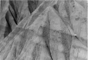
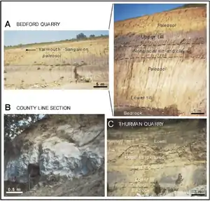
"Examples of pre–Illinoian sections [are in the images on the right]. (A) Two till units with paleosols separated by nonglacial silt and clay unit at site 19 (blow-up of units to left). (B) Lava Creek B ash (0.602 Ma) cropping out near site 4. (C) Two-till unit sequence capped by loess deposits at site 15. Lower till is truncated by sand and gravel unit whereas upper till is affected by paleosol development. Sandy diamicton is present between lower till and bedrock."[26]
Kansan glacial spans 500,000-600,000 yr BP.[30]
MIS Boundary 14/15 is at 563 ka.[23]
MIS Boundary 13/14 is at 533 ka.[23]
"Clay deposition in the Piauí River floodplain around 436 ± 51.5 ka occurred during a warmer period of the Aftonian interglaciation, corresponding to isotope stage 12 (Ericson and Wollin, 1968)."[33]
Yarmouthian age) corroborate a likely assemblages with a maximum age of Illinoian (ca. 220,000-430,000 yr BP) in Unit I."[30]
Yarmouthian spans 420,000-500,000 yr BP.[30]
MIS Boundary 12/13 is at 478 ka.[23]
MIS Boundary 11/12 is at 424 ka.[23]
"Ages of sediments immediately beneath the oldest till (Kellerville Mbr.) in the bedrock valley average 160 ka and provide direct confirmation that Illinois Episode (IE) glaciation began in its type area during marine isotope stage (MIS) 6. The oldest deposits found are 190 ka fluvial sands on bedrock in the deepest part of the valley. These correlate to earliest MIS 6. We now correlate the lowest deposits to the IE (Pearl Fm.)."[34]
The "last two glacial cycles [span] MIS 6 through 2".[34]
"Illinoian [is] (ca. 220,000-430,000 yr BP)".[30]
MIS Boundary 10/11 is at 374 ka.[23]
MIS Boundary 9/10 is at 337 ka.[23]
MIS Boundary 8/9 is at 300 ka.[23]
MIS Boundary 7/8 is at 243 ka.[23]
"OSL dates also suggest that last interglacial (MIS 5; Sangamon Ep.) fluvial deposits are preserved locally."[34]
Age "assignment of Sangamonian (sense alto = 80,000-ca. 220,000 yr BP) [is] to Illinoian (ca. 220,000-430,000 yr BP)".[30]
MIS Boundary 6/7 is at 191 ka.[23]
Late Pleistocene spans ca. 11,000-150,000 yr BP.[30]
MIS Boundary 5/6 is at 130 ka.[23]
The "controversially split Eemian period, the predecessor of our own warm period about 125,000 years ago."[25]
"The Eem interglaciation […] lasted from 131 to 117 kyr B.P."[25]
MIS Boundary 5.5 (peak) is at 123 ka.[23]
The "Brørup interstade [is about] 100 ka BP".[35] It corresponds to GIS 23/24.[36]
MIS Boundary 5.4 (peak) is at 109 ka.[23]
Wisconsinian glacial began at 80,000 yr BP.[30]
MIS Boundary 5.3 is at 96 ka.[23]
MIS Boundary 5.2 (peak) is at 87 ka.[23]
MIS Boundary 5.1 (peak) is at 82 ka.[23]
The Odderade interstadial has a 14C date of 61-72 kyr B.P. and corresponds to GIS 21.[36]
The Karmøy stadial begins in the high mountains of Norway about 60 kyr B.P. and expands to the outer coast by 58 kyr B.P.[36]
The Schalkholz Stadial in North Germany is equivalent.
The Oerel interstadial has a 14C date of 53-58 kyr B.P. and corresponds to GIS 15/16 with a GIS age of 56-59 kyr B.P.[36]
MIS Boundary 3/4 is at 57 ka.[23]
"Genetics suggests Neanderthal numbers dropped sharply around 50,000 years ago. This coincides with a sudden cold snap, hinting climate struck the first blow."[37]
This corresponds to the Skjonghelleren Glaciation of Scandinavia where ice crosses the North Sea between 50-40 ka BP.
The Glinde interstadial has a 14C date of 48-50 kyr B.P. and corresponds to GIS ?13/14 with a GIS age of 49-54.5 kyr B.P.[36]
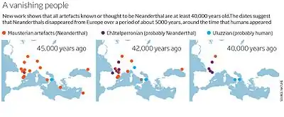
The Moershoofd interstadial has a 14C date of 44-46 kyr B.P. and corresponds to GIS 12 at 45-47 kyr B.P.[36]
The "Hasselo stadial [is] at approximately 40-38,500 14C years B.P. (Van Huissteden, 1990)."[38]
The "Hasselo Stadial [is a glacial advance] (44–39 ka ago)".[39]
"One of two strongly rounded fragments of the mammoth maxilla from the Shapka Quarry in the southern Leningrad region was recently dated at 38450 + 400/–300 years (GrA-39 116) and rhinoceros remains (spoke bone), back to 38360 + 300/–270 years ago (GrA-38 819) [7]. The maxilla fragments occurred in sediments of the Leningrad Interstadial, which correspond to the transition between the Hasselo Stadial (44–39 ka ago) and the Hengelo Interstadial (38–36 ka ago)."[39]
The Hasselo stadial corresponds to the Skjonghelleren stadial in Norway but to the Sejrø interstadial in Denmark.[36]
"Paleomagnetic samples were obtained from cores taken during the drilling of a research well along Coyote Creek in San Jose, California, in order to use the geomagnetic field behavior recorded in those samples to provide age constraints for the sediment encountered. The well reached a depth of 308 meters and material apparently was deposited largely (entirely?) during the Brunhes Normal Polarity Chron, which lasted from 780 ka to the present time."[40]
"Three episodes of anomalous magnetic inclinations were recorded in parts of the sedimentary sequence; the uppermost two we correlate to the Mono Lake (~30 ka) geomagnetic excursion and 6 cm lower, tentatively to the Laschamp (~45 ka) excursion."[40]
"Some 41,000 years ago, a complete and rapid reversal of the geomagnetic field occured. Magnetic studies on sediment cores from the Black Sea show that during this period, during the last ice age, a compass at the Black Sea would have pointed to the south instead of north."[41]
"[A]dditional data from other studies in the North Atlantic, the South Pacific and Hawaii, prove that this polarity reversal was a global event."[41]
"The field geometry of reversed polarity, with field lines pointing into the opposite direction when compared to today's configuration, lasted for only about 440 years, and it was associated with a field strength that was only one quarter of today's field."[41]
"The actual polarity changes lasted only 250 years. In terms of geological time scales, that is very fast."[41]
"During this period, the field was even weaker, with only 5% of today's field strength. As a consequence, Earth nearly completely lost its protection shield against hard cosmic rays, leading to a significantly increased radiation exposure."[41]
"This is documented by peaks of radioactive beryllium (10Be) in ice cores from this time, recovered from the Greenland ice sheet. 10Be as well as radioactive carbon (14C) is caused by the collision of high-energy protons from space with atoms of the atmosphere."[41]
"The polarity reversal [...] has already been known for 45 years. It was first discovered after the analysis of the magnetisation of several lava flows near the village Laschamp near Clermont-Ferrand in the Massif Central, which differed significantly from today's direction of the geomagnetic field. Since then, this geomagnetic feature is known as the 'Laschamp event'."[41]
The "new data from the Black Sea give a complete image of geomagnetic field variability at a high temporal resolution."[41]
The Hengelo interstadial [is] > 35 ka BP".[35]
The "Hengelo Interstadial [is] (38–36 ka ago)."[39]
"An evolution with the coldest phases (coarsest grains) between 27,000 and 10,000 years B.P., 52,000 and 34,000 years B.P., and 76,000 and 60,000 years B.P. and relatively warmer intervals (finer grain size) in between is obvious. Apparently, they reflect a 21,000-year periodicity. This trend is superposed by much shorter oscillations of a duration of one to a few thousand years. Their duration is similar to the Dansgaard-Oeschger oscillations in the ice-core records. Some well-defined stadials and interstadials from the terrestrial records show also such a duration: for instance, the Hengelo interstadial around 37-38,500 14C years B.P. (Zagwijn, 1974; Kasse et al., 1995) and the preceding Hasselo stadial at approximately 40-38,500 14C years B.P. (Van Huissteden, 1990)."[38]
Heinrich Event 4 "33-39.93 ka BP".[42]
The Huneborg interstadial is a Greenland interstadial dating 36.5-38.5 kyr B.P. GIS 8.[36]
The Denekamp interstadial corresponds to the Huneborg interstadial.
"GIS 8 (start) 35.716 [to] GIS 8 (end) 33.977 ka BP".[42]
"Stadial duration 0.642 ka".[42]
"GIS 7 (start) 32.896 [to] GIS 7 (end) 32.15 ka BP".[42]
"Stadial duration 0.932 ka".[42]
The Ålesund interstadial began with GIS 6 and ended after GIS 8.[36]
"GIS 6 (start) 31.218 [to] GIS 6 (end) 30.849 ka BP".[42]
Stadial duration 0.836 ka""[42]
GIS 5 interstadial occurred during the Klintholm advance about 33.5 kyr B.P.[36]
"GIS 5 (start) 30.013 [to] GIS 5 (end) 29.526 ka BP".[42]
This advance occurred after the Møn and ended with GIS 6.[36]
"Stadial duration 2.899 ka".[42]
The Møn interstadial corresponds to GIS 4.[36]
"GIS 4 (start) 26.627 [to] GIS 4 (end) 26.339 ka BP".[42]
Heinrich Event 3 (H3) "occurs at 26.74 ka BP, coincident with the start of the transition into GIS 4."[42]
MIS Boundary 2/3 is at 29 ka.[23]
"Stadial duration 0.768 ka".[42]
The stronger GIS 3 interstadial occurred about 27.6 kyr B.P.[36]
It begins abruptly at 29 ka and ends about 26 ka.
"GIS 3 (start) 25.571 [to] GIS 3 (end) 25.337 ka BP".[42]
This glacial advance begins about 26 ka and ends abruptly at about 23.4 ka.
"Stadial Duration 3.781 ka".[42]
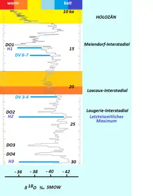
{{free media}}The weak interstadial corresponding to GIS 2 occurred about 23.2 kyr B.P.[36]
"GIS 2 (start) 21.556 [to] GIS 2 (end) 21.407 ka BP".[42]
Heinrich Event 2 (H2) extends "22-25.62 ka BP".[42]
The δ18O values from GISP-2 follow the diagram of Wolfgang Weißmüller. The positions of the Dansgaard-Oeschger events DO1 to DO4 and the Heinrich events H1 to H3 are also indicated. DV 3-4 and DV 6-7 are cold events marked by ice wedges in the upper loess of Dolní Veštonice.
"After c. 22 ka BP [which is] during the Jylland stade (Houmark-Nielsen 1989), Late Weichselian glaciers of the Main Weichselain advance overrode Southeast Denmark from the northeast and later the Young Baltic ice invaded from southeasterly directions. Traces of the Northeast-ice are apparently absent in the Klintholm sections, although large scale glaciotectonic structures and till deposits from this advance are found in Hjelm Bugt and Møns Klint (Aber 1979; Berthelsen 1981, 1986). At Klintholm, the younger phase of glaciotectonic deformation from the southeast and south and deposition of the discordant till (unit 9) were most probably associated with recessional phases of the Young Baltic glaciation. In several cliff sections, well preserved Late Glacial (c. 14-10 ka BP) lacustrine sequences are present (Kolstrup 1982, Heiberg 1991)."[35]
The Lascaux interstadial begins about 21 ka and extends to about 18 ka.
This stadial starts about 17.5 ka, extends to about 15.5 ka and is followed after a brief warming by H1.
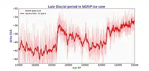
{{free media}}The period spans starting at the far right of the image on the right from Lascaux interstadial to Heinrich event H1, and to Meiendorf/Bölling warm stage, and Allegöd warm stage, to Younger dryas and early holocene.
The Meiendorf Interstadial is typified by a rise in the pollens of dwarf birches (Betula nana), willows (Salix sp.), sandthorns (Hippophae), junipers (Juniperus) and Artemisia.
The beginning of the Meiendorf Interstadial is around 14,700 b2k.
"During the Late Weichselian glacial maximum (20-15 ka BP) the overriding of ice streams eventually lead to strong glaciotectonic displacement of Late Pleistocene and pre-Quaternary deposits and to deposition of till."[35]
"The synchronous and nearly uniform lowering of snowlines in Southern Hemisphere middle-latitude mountains compared with Northern Hemisphere values suggests global cooling of about the same magnitude in both hemispheres at the [Last Glacial Maximum] LGM. When compared with paleoclimate records from the North Atlantic region, the middle-latitude Southern Hemisphere terrestrial data imply interhemispheric symmetry of the structure and timing of the last glacial/interglacial transition. In both regions atmospheric warming pulses are implicated near the beginning of Oldest Dryas time (~14,600 14C yr BP) and near the Oldest Dryas/Bølling transition (~12,700-13,000 14C yr BP). The second of these warming pulses was coincident with resumption of North Atlantic thermohaline circulation similar to that of the modern mode, with strong formation of Lower North Atlantic Deep Water in the Nordic Seas. In both regions, the maximum Bølling-age warmth was achieved at 12,200-12,500 14C yr BP, and was followed by a reversal in climate trend. In the North Atlantic region, and possibly in middle latitudes of the Southern Hemisphere, this reversal culminated in a Younger-Dryas-age cold pulse."[43]
The "intra-Bølling cold period [IBCP is a century-scale cold event and the] Bølling warming [occurs] at 14600 cal [calendar years, ~ b2k] BP (12700 14C BP)".[44]
MIS Boundary 1/2 is at 14 ka.[23]
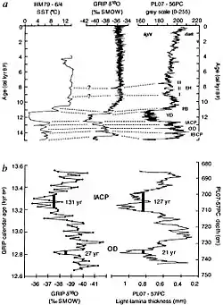
"Older Dryas [...] events [occurred about 13,400 b2k]".[45]
"The most negative δ 18O excursions seen in the GRIP record lasted approximately 131 and 21 years for the [inter-Allerød cold period] IACP and [Older Dryas] OD, respectively. The comparable events in the Cariaco basin were of similar duration, 127 and 21 years. In addition to the chronological agreement, there is also considerable similarity in the decade-scale patterns of variability in both records. Given the geographical distance separating central Greenland from the southern Caribbean Sea, the close match of the pattern and duration of decadal events between the two records is striking."[45]
In the figures on the right, especially b, is a detailed "comparison of δ 18O from the GRIP ice core24 with changes in a continuous sequence of light-lamina thickness measurements from core PL07-57PC. Both records are constrained by annual chronologies, although neither record is sampled at annual resolution. The interval of comparison includes the inter-Allerød cold period (12.9-13 cal. kyr BP) and Older Dryas (13.4 cal. kyr BP) events (IABP and OD from a). The durations of the two events, measured independently in both records, are very similar, as is the detailed pattern of variability at the decadal timescale."[45]
The mesolithic period dates from around 13,000 to 8,500 b2k.
The base of the Neolithic is approximated to 12,200 b2k, ending between 6500 and 4000 b2k.
The "Allerød Chronozone, 11,800 to 11,000 years ago".[46]
The Holocene starts at ~11,700 b2k and extends to the present.
The "Alleröd/Younger Dryas transition [occurred] some 11,000 years ago [11,000 b2k]."[46]
The last glaciation appears to have a gradual decline ending about 12,000 b2k. This may have been the end of the Pre-Boreal transition.
"About 9000 years ago the temperature in Greenland culminated at 4°C warmer than today. Since then it has become slowly cooler with only one dramatic change of climate. This happened 8250 years ago [...]. In an otherwise warm period the temperature fell 7°C within a decade, and it took 300 years to re-establish the warm climate. This event has also been demonstrated in European wooden ring series and in European bogs."[25]
"The Pre-boreal period marks the transition from the cold climate of the Late-glacial to the warmer climate of Post-glacial time. This change is immediately obvious in the field from the nature of the sediments, changing as they do from clays to organic lake muds, showing that at this time a more or less continuous vegetation cover was developing."[47]
"At the beginning of the Pre-boreal the pollen curves of the herbaceous species have high values, and most of the genera associated with the Late-glacial fiora are still present e.g. Artemisia, Polemomium and Thalictrum. These plants become less abundant throughout the Pre-boreal, and before the beginning of the Boreal their curves have reached low values."[47]
"The last remains of the American ice sheet disappeared about 6000 years ago [6,000 b2k], the Scandinavian one 2000 years earlier [8,000 b2k]."[25]
The ancient history period dates from around 8,000 to 3,000 b2k.
The copper age history period began from 6990 b2k.
The "oldest securely dated evidence of copper making, from 7,000 years ago [6990 b2k], at the archaeological site of Belovode, Serbia."[48]
The "Scandinavian one 2000 years earlier [8,000 b2k]."[25]
"In some cores a narrow band of clay interrupts the organic muds, at the horizon of the Boreal Atlantic transition."[47]
The "Atlantic period [is] 4.6–6 ka [4,600-6,000 b2k]."[49]
"The last remains of the American ice sheet disappeared about 6000 years ago [6,000 b2k]".[25]
A general world-wide use of bronze occurred between 5300 and 2600 b2k.
"The first (purely typological) studies on Early Bronze Age (EBA) assemblages in the Jordan Valley settled on the turn of the 4th/3rd millennium BC [mark] the beginnings of the earliest Bronze Age culture (Albright 1932; Mallon 1932)."[50]
"In the Chalcolithic/earliest Bronze Age I period (c. 4500±3000 cal BC), copper was mined in open galleries from the massive brown sandstone deposit, which consisted of thick layers of the copper carbonate malachite and chalcocite, a copper sulphide."[51]
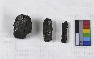
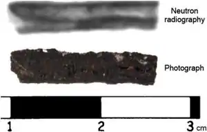
The iron age history period began between 3,200 and 2,100 b2k.
"The earliest known iron artefacts are nine small beads securely dated to circa 3200 BC, from two burials in Gerzeh, northern Egypt."[52]
"Since both tombs are securely dated to Naqada IIC–IIIA, c 3400–3100 BC (Adams, 1990: 25; Stevenson, 2009: 11–31), the beads predate the emergence of iron smelting by nearly 2000 years, and other known meteoritic iron artefacts by 500 years or more (Yalçın 1999), giving them an exceptional position in the history of metal use."[52]
The image on the left uses neutron radiography to show the metal underneath the corrosion.
"Bead UC10738 [in the image on the right] has a maximum length of 1.5 cm and a maximum diameter of 1.3 cm, bead UC10739 is 1.7 cm by 0.7 cm, and bead UC10740 is 1.7 cm by 0.3 cm. All three beads are of rust-brown colour with a rough surface, indicative of heavy iron corrosion. Initial analysis by [proton–induced X–ray fluorescence] pXRF indicated an elevated nickel content of the surface of the beads, in the order of a few per cent, and their magnetic property suggested that iron metal may be present in their body (Jambon, 2010)."[52]
The early history period dates from around 3,000 to 2,000 b2k.
The "period around 850-760 BC [2850-2760 b2k], characterised by a decrease in solar activity and a sharp increase of Δ 14C [...] the local vegetation succession, in relation to the changes in atmospheric radiocarbon content, shows additional evidence for solar forcing of climate change at the Subboreal - Subatlantic transition."[53]
The "Holocene climatic optimum in this interior part of Asia [Lake Baikal] corresponds to the Subboreal period 2.5–4.5 ka".[49]
The "calibration of radiocarbon dates at approximately 2500-2450 BP [2500-2450 b2k] is problematic due to a "plateau" (known as the "Hallstatt-plateau") in the calibration curve [...] A decrease in solar activity caused an increase in production of 14C, and thus a sharp rise in Δ 14C, beginning at approximately 850 cal (calendar years) BC [...] Between approximately 760 and 420 cal BC (corresponding to 2500-2425 BP [2500-2425 b2k]), the concentration of 14C returned to "normal" values."[53]
The classical history period dates from around 2,000 to 1,000 b2k.
Imperial Antiquity lasts from 2,000 to 1,700 b2k.
In Felix Romuliana, "the construction [...] is [...] Imperial Antique (1st-3rd c.), and sometimes even late Hellenistic, [in] appearance."[54]
The Early Middle Ages date from around 1,700 to 1,000 b2k.
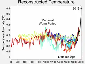
The Medieval Warm Period (MWP) dates from around 1150 to 750 b2k.
The recent history period dates from around 1,000 b2k to present.
The High Middle Ages date from around 1,000 b2k to 700 b2k.
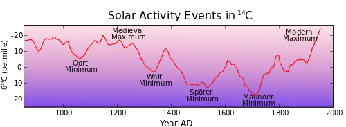
The Little Ice Age (LIA) appears to have lasted from about 1218 (782 b2k) to about 1878 (122 b2k).
Mathematical astronomy
Astrophysics
Technology in all its forms for astronomy
Hypotheses
Each lecture and or article will contain an hypothesis. These lectures are to be a categorized summary of the state of the art or science in preparation for the testing of hypotheses written in sections at the bottom of the page as follows.
- Providing a structural, thematic, and topical outline of radiation astronomy may help students orient to a creative environment.
- Although each announcement was at the top of the page, if readers are not understanding a particular resource is also a creative effort, then the announcement should be returned to the top per consensus.
See also
References
- ↑ M. Thompson, D. M. Wall, R. J. Hicks, H. M. Prince (December 2005). "In vivo tracking for cell therapies". The Quarterly Journal of Nuclear Medicine and Molecular Imaging 49 (4): 339-48. PMID 16407817. http://www.minervamedica.it/index2.t?show=R39Y2005N04A0339. Retrieved 2012-01-03.
- ↑ Sherif Daouti, Brian Higgins, Kenneth Kolinsky, Kathryn Packman, Huisheng Wang, Christine Rizzo, John Moliterni, Nicholas Huby, Nader Fotouhi, Mei Liu, Petra Goelzer, Harpreet K. Sandhu, Jia Kui Li, Aruna Railkar, David Heimbrook and Huifeng Niu (January 2010). "Preclinical In vivo Evaluation of Efficacy, Pharmacokinetics, and Pharmacodynamics of a Novel MEK1/2 Kinase Inhibitor RO5068760 in Multiple Tumor Models". Molecular Cancer Therapeutics 9 (1): 134-44. doi:10.1158/1535-7163.MCT-09-0601. PMID 20053779. http://mct.aacrjournals.org/cgi/pmidlookup?view=long&pmid=20053779. Retrieved 2012-01-03.
- ↑ John A. Wagner (December 2002). "Early clinical development of pharmaceuticals for type 2 diabetes mellitus: from preclinical models to human investigation". The Journal of Clinical Endocrinology & Metabolism 87 (12): 5362-6. doi:10.1210/jc.2002-020910. PMID 12466321. http://jcem.endojournals.org/content/87/12/5362.full.pdf+html. Retrieved 2012-01-03.
- 1 2 Precambrian. San Francisco, California: Wikimedia Foundation, Inc. 4 November 2014. Retrieved 2015-02-12.
- 1 2 Hadean. San Francisco, California: Wikimedia Foundation, Inc. 4 November 2014. Retrieved 2015-02-13.
- 1 2 Eoarchean. San Francisco, California: Wikimedia Foundation, Inc. 4 November 2014. Retrieved 2015-02-12.
- 1 2 Archaean. San Francisco, California: Wikimedia Foundation, Inc. 1 February 2015. Retrieved 2015-02-12.
- 1 2 Paleoarchean. San Francisco, California: Wikimedia Foundation, Inc. 4 November 2014. Retrieved 2015-02-12.
- 1 2 Mesoarchean. San Francisco, California: Wikimedia Foundation, Inc. 4 November 2014. Retrieved 2015-02-12.
- 1 2 Robert E. Kopp, Joseph L. Kirschvink, Isaac A. Hilburn, and Cody Z. Nash (9 August 2005). "The Paleoproterozoic snowball Earth: A climate disaster triggered by the evolution of oxygenic photosynthesis". Proceedings of the National Academy of Sciences of the United States of America 102 (32): 11131–11136. doi:10.1073/pnas.0504878102. http://www.pnas.org/content/102/32/11131.full. Retrieved 2017-05-13.
- 1 2 Neoarchean. San Francisco, California: Wikimedia Foundation, Inc. 8 November 2014. Retrieved 2015-02-12.
- ↑ hypozoic. San Francisco, California: Wikimedia Foundation, Inc. 23 May 2014. Retrieved 2015-02-12.
- 1 2 3 azoic. San Francisco, California: Wikimedia Foundation, Inc. 15 December 2014. Retrieved 2015-02-12.
- ↑ Proterozoic. San Francisco, California: Wikimedia Foundation, Inc. 1 January 2015. Retrieved 2015-02-13.
- 1 2 James S. Aber (2008). GLACIATIONS THROUGHOUT EARTH HISTORY. Emporia, Kansas USA: Emporia State University. Retrieved 2014-11-06.
- ↑ Paleoproterozoic. San Francisco, California: Wikimedia Foundation, Inc. 4 November 2014. Retrieved 2015-02-13.
- ↑ Mesoproterozoic. San Francisco, California: Wikimedia Foundation, Inc. 7 October 2013. Retrieved 2015-02-13.
- ↑ Neoproterozoic. San Francisco, California: Wikimedia Foundation, Inc. 7 October 2013. Retrieved 2015-02-13.
- 1 2 M Gargaud, H Martin, P López-García (2012). A Planet Where Life Diversifies, In: Young Sun, Early Earth and the Origins of Life. Berlin: Springer. pp. 211-39. doi:10.1007/978-3-642-22552-9_7. ISBN 978-3-642-22551-2. http://link.springer.com/chapter/10.1007/978-3-642-22552-9_7/fulltext.html. Retrieved 2014-11-06.
- 1 2 3 4 5 6 Felix M. Gradstein, Frits P. Agterberg, James G. Ogg, Jan Hardenbol, Paul Van Veen, Jacques Thierry, and Zehui Huang (1995). A Triassic, Jurassic and Cretaceous Time Scale, In: Geochronology Time Scales and Global Stratigraphic Correlation. SEPM Special Publication No. 54. Society for Sedimentary Geology. doi:1-56576-024-7. http://archives.datapages.com/data/sepm_sp/SP54/A_Triassic_Jurassic_and_Cretaceous_Time_Scale.htm. Retrieved 2017-05-13.
- ↑ Gaidheal1 (16 May 2012). Cretaceous Period, In: Wikiversity. Retrieved 2012-07-24.
- ↑ John A. Van Couvering, Davide Castradori, Maria Bianca Cita, Frederik J. Hilgen, and Domenico Rio (September 2000). [http://www.stratigraphy.org/GSSP/Zanclean.pdf "The base of the Zanclean Stage and of the Pliocene Series"]. Episodes 23 (3): 179-87. http://www.stratigraphy.org/GSSP/Zanclean.pdf. Retrieved 2015-01-23.
- 1 2 3 4 5 6 7 8 9 10 11 12 13 14 15 16 17 18 19 20 21 22 23 24 25 26 27 28 29 30 31 32 33 34 35 36 37 38 39 40 41 42 43 44 45 46 47 48 49 50 51 52 53 54 55 56 57 58 59 60 61 62 63 64 65 66 67 68 69 70 71 72 73 74 75 76 77 78 79 80 81 82 83 84 85 86 87 88 89 90 91 92 93 94 95 96 97 98 99 100 101 102 103 104 105 106 107 108 109 110 111 112 113 114 115 116 117 118 119 120 121 122 123 124 125 126 127 128 129 130 131 132 133 134 135 136 137 138 139 140 141 142 143 144 145 146 147 148 149 150 151 152 153 154 155 156 157 158 159 160 161 162 163 164 165 166 167 168 169 170 171 172 173 174 175 176 177 178 179 180 181 182 183 184 185 186 187 188 189 190 191 192 193 194 195 196 197 198 199 200 201 202 203 204 205 206 207 208 209 210 211 212 213 214 215 216 217 218 219 220 221 222 223 224 225 226 227 228 229 230 231 Lisiecki, L.E., 2005, Ages of MIS boundaries. LR04 Benthic Stack Boston University, Boston, MA
- ↑ D. Castradori, D. Rio, F. J. Hilgen, and L. J. Lourens (June 1998). "The Global Standard Stratotype-section and Point (GSSP) of the Piacenzian Stage (Middle Pliocene)". Episodes 21 (2): 88-93. http://www.stratigraphy.org/GSSP/Piacenzian.pdf. Retrieved 2015-01-23.
- 1 2 3 4 5 6 7 Willi Dansgaard (2005). The Department of Geophysics of The Niels Bohr Institute for Astronomy Physics and Geophysics at The University of Copenhagen Denmark (ed.). Frozen Annals Greenland Ice Cap Research. Copenhagen, Denmark: Niels Bohr Institute. p. 123. ISBN 87-990078-0-0. Retrieved 2014-10-05.
- 1 2 3 4 5 6 7 8 M. Roy, P.U. Clark, R.W. Barendregt, J.R. Glasmann, and R.J. Enkin (January/February 2004). "Glacial stratigraphy and paleomagnetism of late Cenozoic deposits of the north-central United States". Geological Society of America Bulletin 116 (1/2): 30-41. doi:10.1130/B25325.1. http://geo.oregonstate.edu/files/geo/Royetal-GSAB-2004.pdf. Retrieved 2017-06-16.
- ↑ Philip L. Gibbard and Martin J. Head (September 2010). "The newly-ratified definition of the Quaternary System/Period and redefinition of the Pleistocene Series/Epoch, and comparison of proposals advanced prior to formal ratification". Episodes 33 (3): 152-8. http://www.stratigraphy.org/GSSP/Quaternary&Pleistocene.pdf. Retrieved 2015-01-20.
- ↑ D. Rio, R. Sprovieri, D. Castradori, and E. Di Stefano (June 1998). "The Gelasian Stage (Upper Pliocene): A new unit of the global standard chronostratigraphic scale". Episodes 21 (2): 82-7. http://www.stratigraphy.org/GSSP/Gelasian.pdf. Retrieved 2015-01-20.
- 1 2 Maria Bianca Cita, Philip L. Gibbard, Martin J. Head, and the ICS Subcommission on Quaternary Stratigraphy (September 2012). "Formal ratification of the GSSP for the base of the Calabrian Stage (second stage of the Pleistocene Series, Quaternary System)". Episodes 35 (3): 388-97. http://www.stratigraphy.org/GSSP/Calabrian2.pdf. Retrieved 2015-01-18.
- 1 2 3 4 5 6 7 8 9 10 11 Sam L. VanLandingham (May 2010). "Use of diatoms in determining age and paleoenvironment of the Valsequillo (Hueyatiaco) early man site, Puebla, Mexsico, with corroboration by Chrysophyta cysts for a maximum Yarmouthian (430,000-500,00yr BP) age of the artifacts". Nova Hedwigia 136: 127-38. http://www.pleistocenecoalition.com/vanlandingham/VanLandingham_2010b.pdf. Retrieved 2017-06-16.
- 1 2 3 4 Andrew L. Darling, Karl E. Karlstrom, Andres Aslan, Rex Cole, Charles Betton, and Elmira Wan (May 2009). "Quaternary incision rates and drainage evolution of the Uncompahgre and Gunnison Rivers, western Colorado, as calibrated by the Lava Creek B ash". Rocky Mountain Geology 44 (1): 71–83. doi:10.1130/B25325.1. https://www.researchgate.net/profile/Andrew_Darling/publication/250085188_Quaternary_incision_rates_and_drainage_evolution_of_the_Uncompahgre_and_Gunnison_Rivers_western_Colorado_as_calibrated_by_the_Lava_Creek_B_ash/links/5580978b08ae607ddc3226ca.pdf. Retrieved 2017-06-11.
- ↑ Chris Widga, Tara L. Fulton, Larry D. Martin and Beth Shapiro (October 2012). "Homotherium serum and Cervalces from the Great Lakes Region, USA: geochronology, morphology and ancient DNA". Boreas 41 (4): 547-56. doi:1111/j.1502-3885.2012.00267.x. http://pgl.soe.ucsc.edu/widga12.pdf. Retrieved 2015-01-20.
- ↑ Janaina C. Santos; Alcina Magnólia Franca BarretoII; Kenitiro Suguio (16 August 2012). "Quaternary deposits in the Serra da Capivara National Park and surrounding area, Southeastern Piauí state, Brazil". Geologia USP. Série Científica 12 (3). doi:10.5327/Z1519-874X2012000300008. http://ppegeo.igc.usp.br/scielo.php?pid=S1519-874X2012000300009&script=sci_arttext. Retrieved 2015-01-20.
- 1 2 3 E. Donald McKay III (24-25 April 2008). "Optical Ages Spanning Two Glacial-Interglacial Cycles from Deposits of the Ancient Mississippi River, North-Central Illinois". Geological Society of America Abstracts with Programs 40 (5): 78. https://gsa.confex.com/gsa/2008NC/finalprogram/abstract_137641.htm. Retrieved 2017-06-16.
- 1 2 3 4 Michael Houmark-Nielsen, (30 November 1994). "Late Pleistocene stratigraphy, glaciation chronology and Middle Weichselian environmental history from Klintholm, Møn, Denmark". Bulletin of the Geological Society of Denmark 41 (2): 181-202. http://2dgf.dk/xpdf/bull41-02-181-202.pdf. Retrieved 2014-11-03.
- 1 2 3 4 5 6 7 8 9 10 11 12 13 14 Barbara Wohlfarth (April 2010). "Ice-free conditions in Sweden during Marine Oxygen Isotope Stage 3?". Boreas 39: 377-98. doi:10.1111/j.1502-3885.2009.00137.x. http://people.su.se/~wohlf/pdf/Wohlfarth%20Boreas%202010.pdf. Retrieved 2014-11-06.
- ↑ Catherine Brahic (8 August 2014). Human exodus may have reached China 100,000 years ago. New Scientist. Retrieved 2014-08-16.
- 1 2 J. Vandenberghe and G. Nugteren (2001). "Rapid climatic changes recorded in loess successions". Global and Planetary Change 28 (1-9): 222-30. http://shixi.bnu.edu.cn/field-trips/cooperation/ChinaSweden/the%20link/1.1.4.pdf. Retrieved 2014-11-06.
- 1 2 3 A.A. Nikonov, M.M. Shakhnovich, J. van der Plicht (2011). "Age of Mammoth Remains from the Submoraine Sediments of the Kola Peninsula and Karelia". Doklady Earth Sciences 436 (2): 308-10. http://cio.eldoc.ub.rug.nl/FILES/root/2011/DoklEarthSciNikonov/2011DoklEarthSciNikonov.pdf?origin=publication_detail. Retrieved 2014-11-06.
- 1 2 Edward A. Mankinen and Carl M. Wentworth (10 June 2003). Preliminary Paleomagnetic Results from the Coyote Creek Outdoor Classroom Drill Hole, Santa Clara Valley, California. U.S. Geological Survey. Retrieved 2016-11-04.
- 1 2 3 4 5 6 7 8 Norbert R. Nowaczyk and Helge Arz (16 October 2012). Ice age polarity reversal was global event: Extremely brief reversal of geomagnetic field, climate variability, and super volcano. ScienceDaily: Helmholtz Centre Potsdam - GFZ German Research Centre for Geosciences. Retrieved 2016-11-04.
- 1 2 3 4 5 6 7 8 9 10 11 12 13 14 15 16 Sasha Naomi Bharier Leigh (2007). A STUDY OF THE DYNAMICS OF THE BRITISH ICE SHEET DURING MARINE ISOTOPE STAGES 2 AND 3, FOCUSING ON HEINRICH EVENTS 2 AND 4 AND THEIR RELATIONSHIP TO THE NORTH ATLANTIC GLACIOLOGICAL AND CLIMATOLOGICAL CONDITIONS (PDF). St Andrews, Scotland: University of St Andrews. p. 219. Retrieved 2017-02-16.
- ↑ George H. Denton, Thomas V. Lowell, Calvin J. Heusser, Patricio I. Moreno, Bjørn G. Andersen, Linda E. Heusser, Christian Schlüchter, David R. Marchant (1999). "Interhemispheric Linkage of Paleoclimate during the Last Glaciation". Geografiska Annaler. Series A, Physical Geography 81A (2): 107-53. http://people.bu.edu/marchant/Dave_FullText_Papers/Denton_GA_1999.pdf. Retrieved 2014-11-05.
- ↑ Zicheng Yu and Ulrich Eicher (2001). "Three Amphi-Atlantic Century-Scale Cold Events during the Bølling-Allerød Warm Period". Géographie physique et Quaternaire 55 (2): 171-9. doi:10.7202/008301ar. http://www.lehigh.edu/~ziy2/pubs/YuGpQPreprint.pdf. Retrieved 2014-11-04.
- 1 2 3 Konrad A. Hughes, Jonathan T. Overpeck, Larry C. Peterson & Susan Trumbore (7 March 1996). Rapid climate changes in the tropical Atlantic region during the last deglaciation. 380. pp. 51-4. http://www.diagonalarida.cl/SemV/Hughen_etal_1996_tropicalAtlantic.pdf. Retrieved 2014-11-05.
- 1 2 Jan Mangerud (1987). W. H. Berger and L. D. Labeyrie (ed.). The Alleröd/Younger Dryas Boundary, In: Abrupt Climatic Change (PDF). D. Reidel Publishing Company. pp. 163–71. Retrieved 2014-11-03.
- 1 2 3 J. W. Franks and W. Pennington (April 1961). "The Late-Glacial and Post-Glacial Deposits of the Esthwaite Basin, North Lancashire". New Phytologist 60 (1): 27-42. http://onlinelibrary.wiley.com/store/10.1111/j.1469-8137.1961.tb06237.x/asset/j.1469-8137.1961.tb06237.x.pdf;jsessionid=EB6966DF0A2FBCC3534CCD6A6413808D.f02t01?v=1&t=i23es9k1&s=e619673cf5bc8be51450a303a914df03f8cba94d. Retrieved 2014-11-04.
- ↑ Miljana Radivojevic and Thilo Rehren (23 September 2010). Serbian site may have hosted first copper makers. London, England: UCL Institute of Archaeology. Retrieved 2015-01-18.
- 1 2 E.B. Karabanov, A.A. Prokopenko, D.F. Williams, and G.K. Khursevich (March 2000). "A new record of Holocene climate change from the bottom sediments of Lake Baikal". Palaeogeography, Palaeoclimatology, Palaeoecology 156 (3-4): 211–24. doi:10.1016/S0031-0182(99)00141-8. http://www.sciencedirect.com/science/article/pii/S0031018299001418. Retrieved 2014-11-04.
- ↑ S Bourke, U Zoppi, J Meadows, Q Hua, S Gibbins (January 2009). "The beginning of the Early Bronze Age in the north Jordan Valley: new 14C determinations from Pella in Jordan". Radiocarbon 51 (3): 905-913. doi:10.2458/azu_js_rc.51.3549. https://www.researchgate.net/profile/Quan_Hua2/publication/260038389_The_Beginning_of_the_Early_Bronze_Age_in_the_North_Jordan_Valley_New_14C_determinations_from_Pella_in_Jordan/links/00b49537d32bf17b4a000000.pdf. Retrieved 2016-10-23.
- ↑ B.S. Ottaway (2001). "Innovation, production and specialization in early prehistoric copper metallurgy". European Journal of Archaeology 4 (1): 87-112. doi:10.1179/eja.2001.4.1.87. http://www.tandfonline.com/doi/abs/10.1179/eja.2001.4.1.87. Retrieved 2016-10-23.
- 1 2 3 Thilo Rehrena, Tamás Belgya, Albert Jambon, György Káli, Zsolt Kasztovszky, Zoltán Kis, Imre Kovács, Boglárka Maróti, Marcos Martinón-Torres, Gianluca Miniaci, Vincent C. Pigott, Miljana Radivojević, László Rosta, László Szentmiklósi, Zoltán Szőkefalvi-Nagy (December 2013). "5,000 years old Egyptian iron beads made from hammered meteoritic iron". Journal of Archaeological Science 40 (12): 4785–92. doi:10.1016/j.jas.2013.06.002. http://www.sciencedirect.com/science/article/pii/S0305440313002057. Retrieved 2016-10-23.
- 1 2 A. Speranza, J. van der Plicht, and B. van Geel (November 2000). "Improving the time control of the Subboreal/Subatlantic transition in a Czech peat sequence by 14C wiggle-matching". Quaternary Science Reviews 19 (16): 1589-1604. doi:10.1016/S0277-3791(99)00108-0. http://www.researchgate.net/publication/30494985_Improving_the_time_control_of_the_SubborealSubatlantic_transition_in_a_Czech_peat_sequence_by_14C_wiggle-matching/file/60b7d51c350cf2efa0.pdf. Retrieved 2014-11-04.
- ↑ Gunnar Heinsohn (15 March 2017). Felix Romuliana. Q Magazine. Retrieved 2017-05-13.
External links
- Bing Advanced search
- Astronomy Picture of the Day
- Google Books
- Google scholar Advanced Scholar Search
- International Astronomical Union
- JSTOR
- Lycos search
- NASA/IPAC Extragalactic Database - NED
- NASA's National Space Science Data Center
- NCBI All Databases Search
- NCBI Site Search
- Office of Scientific & Technical Information
- PubChem Public Chemical Database
- Questia - The Online Library of Books and Journals
- SAGE journals online
- The SAO/NASA Astrophysics Data System
- Scirus for scientific information only advanced search
- SDSS Quick Look tool: SkyServer
- SIMBAD Astronomical Database
- SIMBAD Web interface, Harvard alternate
- Spacecraft Query at NASA
- SpringerLink
- Taylor & Francis Online
- Universal coordinate converter
- Wiley Online Library Advanced Search
- Yahoo Advanced Web Search
{{Radiation astronomy resources}}