Volcanology is the scientific study of volcanoes.
Volcanology is the study of the Earth's volcanic activity, processes, products and causes.
Volcanic minerals

Volcanic minerals are the ones expected to be found in volcanic rocks.
Theoretical volcanology
Def. the scientific study of volcanoes is called volcanology.
Vulcanology is a variant spelling of volcanology.
"The word "volcano" is used to refer to the opening from which molten rock and gas issue from Earth's interior onto the surface, and also to the cone, hill, or mountain built up around the opening by the eruptive products. [These products include] ash clouds, fire fountains, lava flows, spatter cones, glowing avalanches, and steam eruptions [...]. Volcano types include strato, cinder cone, basaltic shield, complex, and island-forming."[1]
Theoretical volcanoes
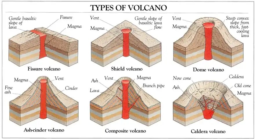
The diagram at top shows six theoretical types of volcanoes:
- fissure,
- shield,
- dome,
- ash-cinder,
- composite, and
- caldera.
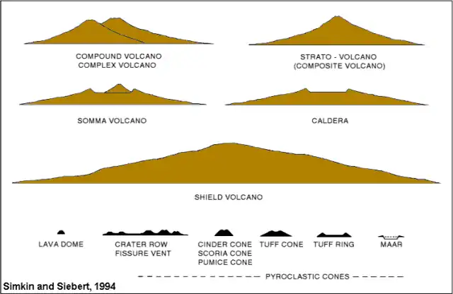
The second diagram shows
- a compound and complex volcano,
- a composite volcano,
- a somma volcano with cone inside earlier cone,
- a caldera,
- a shield volcano, and remnants
- lava dome,
- fissure vent row of craters,
- a cinder cone profile,
- a tuff cone,
- a tuff ring, and
- a maar.
Def. a mountain or hill, typically conical, having a crater or vent through which lava, rock fragments, hot vapor, and gas are or have been erupted from the Earth's, or another astronomical object's crust is called a volcano.
Def. a vent or fissure on the surface of a planet (usually in a mountainous form) with a magma chamber attached to the mantle of a planet or moon, periodically erupting forth lava and volcanic gases onto the surface is called a volcano.
A volcano is a rupture on the crust of a planetary-mass object, such as Earth, that allows hot lava, volcanic ash, and gases to escape from a magma chamber below the surface.
Def. a powerful volcano, often having an explosive or cataclysmic eruption is called a supervolcano.
Geology
With respect to volcanoes, the geology consists of the study of the materials they are made of, the processes that act on these materials, the products formed, and the history of these volcanoes and effects on life forms since each volcano's origin.
Electromagnetics
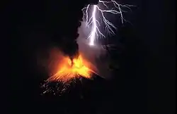
Many volcanic eruptions put on impressive lightning displays such as during the 1995 eruption of Mount Rinjani in Indonesia shown in the image on the right.
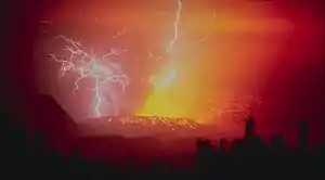
The image on the left shows spectacular lightning strikes around Galunggung.
"This stratovolcano with a lava dome is located in western Java. Its first eruption in 1822 produced a 22-km-long mudflow that killed 4,000 people. The second eruption in 1894 caused extensive property loss. The photo depicts a spectacular view of lightning strikes during a third eruption on December 3, 1982, which resulted in 68 deaths. A fourth eruption occurred in 1984."[1]
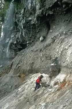
Volcanic rocks

"The behavior of a lava flow depends primarily on its viscosity (resistance to flow), slope of the ground over which it travels, and the rate of lava eruption. Because basalt contains the least amount of silica and erupts at the highest temperature compared to the other types of lava, it has the lowest viscosity (the least resistance to flow). Thus, basalt lava moves over the ground easily, even down gentle slopes. Dacite and rhyolite lava, however, tend to pile up around a vent to form short, stubby flows or mound-shaped domes."[2]
Geoseismology
Sound "propagating through the [Sound Fixing and Ranging] SOFAR channel [may be used] to study underwater earthquakes, volcanoes and whales."[3]
"Between 100 and 200 kilometers below the Earth's surface, the temperature of the rock is near the melting point; molten rock erupted by some volcanoes originates in this region of the mantle."[4]
Monochromatic "seismic signals, typically between 3 and 12 Hz, with a lack of overtones [occurred on some seismic recordings from French Polynesia]. The signals were due to oceangoing T- waves, which were particularly active in 1991 and in the early months of 1992. The duration of individual blasts lasted from a few seconds to several minutes. [...] earthquakes and whales [were ruled out] as the source of the T-waves."[5]
The "waves originated at an underwater volcanic ridge in a poorly surveyed region of the South Pacific. New probing showed a flat-topped undersea volcano that rose to within 130 meters of the surface. [...] undersea volcanoes at shallow depths [are] capable of producing T-waves, where the pressure is low enough that bubbles can form in the hot lava."[5]
"Sound waves normally travel at about 1500 meters per second in seawater, but they can slow to one meter per second in a cloud of bubbles generated by the steam from a volcano."[5]
Volcanic activity

Volcanic activity may be activity from or by a volcano or activity from the sources of volcanoes.
On Iceland this year there is an increase in volcanic activity as shown in the photo on the right.
"Our research makes the connection between recent accelerated uplift and the accelerated melting of the Icelandic ice caps."[6]
"There is actually geological evidence that during the past deglaciation about 12,000 years ago, volcanic activity in some regions of Iceland increased thirtyfold. In fact, some estimate that this uplift could increase the frequency of volcanic eruptions such as the 2010 eruption of Eyjafjallajokull, which had negative consequences worldwide."[7]
Volcanicity

Def. the "level of power of a volcano"[8] is called its volcanicity.
"The Volcanic Explosivity Index, or VEI, was proposed in 1982 [shown on the right] as a way to describe the relative size or magnitude of explosive volcanic eruptions. It is a 0-to-8 index of increasing explosivity. Each increase in number represents an increase around a factor of ten. The VEI uses several factors to assign a number, including volume of erupted pyroclastic material (for example, ashfall, pyroclastic flows, and other ejecta), height of eruption column, duration in hours, and qualitative descriptive terms."[9]
"In the figure [on the right], the volumes of several past explosive eruptions and the corresponding VEI are shown. Numbers in parentheses represent total volume of erupted pyroclastic material (tephra, volcanic ash, and pyroclastic flows) for selected eruptions; the volumes are for uncompacted deposits. Each step increase represents a ten fold increase in the volume of erupted pyroclastic material."[9]
"A series of small to moderate explosive eruptions from Mono-Inyo Craters Volcanic Chain, California, during the past 5,000 years ranged from VEI of 1 to 3. The 18 May 1980 eruption of Mount St. Helens was a VEI 5 with an erupted volume of about 1 km3. The 1991 eruption of Mount Pinatubo had a volume of about 10 km3 and a VEI of 5 to 6. The 1815 eruption of Tambora, Indonesia, had a VEI of 7 and a volume in excess of 100 km3. The eruption of Long Valley Caldera about 760,000 years ago had a VEI of 7 and a volume of 600 km3 of material. The largest explosive eruption on the figure occurred at Yellowstone about 600,000 years ago with a VEI of 8 and a volume of about 1,000 km3 of material."[9]
"The VEI has some similarities to the Richter magnitude scale used to measure earthquakes. It has a simple numerical index of increasing magnitude of explosivity, with each interval representing an increase of about a factor of 10 in the volume of erupted tephra."[9]
"There are no known explosive events with a VEI larger than 8."[9]
The "amount of sulfur dioxide gas injected high into the atmosphere (which is not necessarily related to the size of an eruption) [is] a critical factor in determining the climatic impact of volcanic eruptions. [The] VEI is primarily used to estimate the relative size of an explosive eruption."[9]
"Large explosive eruptions occur much less frequently than small ones. Through 1994, the record of volcanic eruptions in the past 10,000 years maintained by the Global Volcanism Program of the Smithsonian Institution shows that there have been 4 eruptions with a VEI of 7, 39 of VEI 6, 84 of VEI 5, 278 of VEI 4, 868 of VEI 3, and 3,477 explosive eruptions of VEI 2."[9]
Volcanism
Def. any remnants "of the natural phenomena and processes associated with the action of volcanos, geysers and fumaroles"[10], especially any remnants of past volcanic activity, are called volcanism.
In contrast to the Proterozoic, Archean rocks are often heavily metamorphized deep-water sediments, such as graywackes, mudstones, volcanic sediments and banded iron formations. Greenstone belts are typical Archean formations, consisting of alternating high- and low-grade metamorphic rocks. The high-grade rocks were derived from volcanic island arcs, while the low-grade metamorphic rocks represent deep-sea sediments eroded from the neighboring island arcs and deposited in a forearc basin. In short, greenstone belts represent sutured protocontinents.[11]
Greenstone belts are zones of variably metamorphosed mafic to ultramafic volcanic sequences with associated sedimentary rocks that occur within Archaean and Proterozoic cratons between granite and gneiss bodies.
The name comes from the green hue imparted by the colour of the metamorphic minerals within the mafic rocks. Chlorite, actinolite and other green amphiboles are the typical green minerals.
A greenstone belt is typically several dozens to several thousand kilometres long and although composed of a great variety of individual rock units, is considered a 'stratigraphic grouping' in its own right, at least on continental scales.
"Greenstone belts" are distributed throughout geological history from the Phanerozoic Franciscan belts of California where blueschist, whiteschist and greenschist facies are recognised, through to the Palaeozoic greenstone belts of the Lachlan Fold Belt, Eastern Australia, and a multitude of Proterozoic and Archaean examples.
Archaean greenstones are found in the Slave craton, northern Canada, Pilbara craton and Yilgarn Craton, Western Australia, Gawler Craton in South Australia, and in the Wyoming Craton in the US. Examples are found in South and Eastern Africa, namely the Kaapvaal craton and also in the cratonic core of Madagascar, as well as West Africa and Brazil, northern Scandinavia and the Kola Peninsula (see Baltic Shield).
Phanerozoic ophiolite belts and greenstone belts occur in the Franciscan Complex of south-western North America, within the Lachlan Fold Belt, the Gympie Terrane of Eastern Australia, the ophiolite belts of Oman and around the Guiana Shield.
Volcanic ashes

"Volcanic ash collected in Randle, Washington, [in the image on the right, is] located about 40 km NNE of Mount St. Helens."[12]
"The north edge of the eruption cloud of May 18, 1980, passed over Randle and deposited between 1 and 2 cm of ash on the community. At the same distance along the axis of the eruption cloud, however, about 7 cm of ash and larger-sized tepra fell to the ground."[12]
"Volcanic ash consists of rock, mineral, and volcanic glass fragments smaller than 2 mm (0.1 inch) in diameter, which is slightly larger than the size of a pinhead. Volcanic ash is not the same as the soft fluffy ash that results from burning wood, leaves, or paper. It is hard, does not dissolve in water, and can be extremely small--ash particles less than 0.025 mm (1/1,000th of an inch) in diameter are common."[12]
"Ash is extremely abrasive, similar to finely crushed window glass, mildly corrosive, and electrically conductive, especially when wet."[12]
"Volcanic ash is created during explosive eruptions by the shattering of solid rocks and violent separation of magma (molten rock) into tiny pieces. Explosive eruptions are generated when ground water is heated by magma and abruptly converted to steam and also when magma reaches the surface so that volcanic gases dissolved in the molten rock expand and escape (explode) into the air extremely rapidly. After being blasted into the air by expanding steam and other volcanic gases, the hot ash and gas rise quickly to form a towering eruption column directly above the volcano."[12]
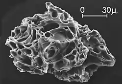
The second image down on the right is a close "view of a single ash particle from the eruption of Mount St. Helens; image is from a scanning electron microscope (SEM). The tiny voids or "holes" are called vesicles and were created by expanding gas bubbles during the eruption of magma."[12]
Hotspots
A hotspot is a plume of magma that travels through a stable section of crust. They are different than magma that arises from plate boundries, as they weaken the crust that might have been weak in the first place.
Hotspots are stationary, unlike other magma sources. This means that as the continents shift they move over these hotspots causing volcanoes. An example of a hotspot are the islands of Hawaii. The moving plate has formed a chain of islands which is also an indicatior of which way the plate is shifting.
Magmas
Def. "molten matter within the earth, the source of the material of lava flows, dikes of eruptive rocks, etc"[13] is called a magma.
Magma (from Ancient Greek μάγμα (mágma) meaning "thick unguent"[14]) is the molten or semi-molten natural material from which all igneous rocks are formed.[15] Magma is found beneath the surface of the Earth, and evidence of magmatism has also been discovered on other terrestrial planets and some natural satellites.[16] Besides molten rock, magma may also contain suspended crystals and gas bubbles.[17] Magma is produced by melting of the mantle and/or the crust at various tectonic settings, including subduction zones, continental rift zones,[18] mid-ocean ridges and hotspots. Mantle and crustal melts migrate upwards through the crust where they are thought to be stored in magma chambers[19] or trans-crustal crystal-rich mush zones.[20] During their storage in the crust, magma compositions may be modified by fractional crystallization, contamination with crustal melts, magma mixing, and degassing. Following their ascent through the crust, magmas may feed a volcano or solidify underground to form an intrusion[21] (e.g., an igneous dike or a sill). While the study of magma has historically relied on observing magma in the form of lava flows, magma has been encountered in situ three times during geothermal drilling projects—twice in Iceland (see Magma usage for energy production), and once in Hawaii.[22][23][24]
Most magmatic liquids are rich in silica.[21] The physical behaviours of melts depend upon their atomic structures as well as upon temperature and pressure and composition.[25]
Temperatures of most magmas are in the range 700 °C to 1300 °C (or 1300 °F to 2400 °F), but very rare carbonatite magmas may be as cool as 490 °C,[26] and komatiite magmas may have been as hot as 1600 °C.[27]
| Type | Density (kg/m3) |
|---|---|
| Basalt magma | 2650–2800[28] |
| Andesite magma | 2450–2500[28] |
| Rhyolite magma | 2180–2250[28] |
The most common mechanisms of magma generation in the mantle are decompression melting,[29] heating (e.g., by interaction with a hot mantle plume[30]), and lowering of the solidus (e.g., by compositional changes such as the addition of water[31]).
Under pressure within the earth, as little as a fraction of a percent of partial melting may be sufficient to cause melt to be squeezed from its source.[32]
The "Borgarhraun eruption of Theistareykir, a volcano in northern Iceland, [...] took place around 10,000 years ago. Previous studies have shown the magma that fed this eruption came directly from the Mohorovičić discontinuity (the Moho), where Earth’s crust meets its mantle, at a depth of about 24 kilometers—far deeper than geophysical methods can see clearly."[33]
"The elements in the crystal [spinel] want to be in equilibrium with the surroundings."[34]
"As the elements equilibrate by diffusing out of the spinel, the mineral’s composition changes, creating a kind of crystal clock. Using known diffusion rates for aluminum and chromium, [...] the minerals were stored in the melt before it erupted [...] about a thousand years".[33]
A "similar diffusion modeling technique on olivine crystals [was used] to show that the magma ascended from the Moho to the surface in as little as 4 days, at a rate of 0.02 to 0.1 meter per second."[33]
"A lot of progress has been made understanding timescales of shallower volcanoes, but these are the first studies to estimate how long magma is stored in the deep crust before it erupts. That’s crucial new information."[35]
Mutch and colleagues "were very clever in working out the uncertainties and arrived at much more precise estimates for these timescales than previous groups have been able to do."[35]
"Their results contribute to the evidence that supports vertically extensive transcrustal magma systems, [and] supports this emerging new paradigm. The paper is amongst the most thorough and convincing published so far."[36]
"Most volcanoes are ultimately underlain by basaltic materials, even if they’re erupting rhyolite or andesite at the surface like at the Cascades volcanoes [in the United States]. I think this approach will prove to be widely applicable to a range of volcanic settings."[35]
"At the ascent rates estimated for the Borgarhraun magma, an increase in carbon dioxide flux at the surface would only be detected at most 2 days before the eruption. This threshold will be different for magmas with different carbon contents and that are stored at different depths before eruption."[34]
Hypotheses
- Volcanology may involve more electromagnetism than currently assumed.
See also
References
- 1 2 R. Hadian (3 December 1982). Galunggung, Indonesia. NOAA National Geophysical Data Center. Retrieved 2015-03-24.
- ↑ J. Johnson (29 December 2009). VHP Photo Glossary: Volcanic rocks. Menlo Park, California USA: USGS. Retrieved 2015-03-15.
- ↑ Tom Irvine (June 2006). SOFAR Channel (PDF). VibrationData.com. Retrieved 2014-11-26.
- ↑ Eugene C. Robertson (14 January 2011). The Interior of the Earth. Reston, Virginia USA: USGS. Retrieved 2014-12-01.
- 1 2 3 Tom Irvine (June 2006). Seismo-acoustic T-waves (PDF). VibrationData.com. Retrieved 2014-11-26.
- ↑ Kathleen Compton (30 January 2015). Melting Glaciers is Causing Iceland to Rise and May Increase Volcanic Activity. Iceland: Science World Report. Retrieved 2015-03-27.
- ↑ Catherine Griffin (30 January 2015). Melting Glaciers is Causing Iceland to Rise and May Increase Volcanic Activity. Iceland: Science World Report. Retrieved 2015-03-27.
- ↑ Borganised (23 October 2008). volcanicity. San Francisco, California: Wikimedia Foundation, Inc. Retrieved 2015-03-21.
- 1 2 3 4 5 6 7 C. G. Newhall and S. Self (29 December 2009). VHP Photo Glossary: VEI. Menlo Park, California USA: United States Geological Survey. Retrieved 2015-02-28.
- ↑ SemperBlotto (5 July 2007). volcanism. San Francisco, California: Wikimedia Foundation, Inc. Retrieved 2015-03-20.
- ↑ Stanley 1999, pp. 302–303
- 1 2 3 4 5 6 D.E. Wieprecht (18 May 1980). VHP Photo Glossary: volcanic ash. Menlo Park, California USA: USGS. Retrieved 2015-03-09.
- ↑ Poccil (18 October 2004). "magma". San Francisco, California: Wikimedia Foundation, Inc. Retrieved 2015-02-17.
- ↑ "Definition of Magma". Merriam-Webster Dictionary. Merriam-Webster. Retrieved 28 October 2018.
- ↑ BOWEN, NORMAN L. (1947). "MAGMAS". Geological Society of America Bulletin 58 (4): 263. doi:10.1130/0016-7606(1947)58[263:M]2.0.CO;2. ISSN 0016-7606. https://pubs.geoscienceworld.org/gsa/gsabulletin/article-abstract/58/4/263/4157.
- ↑ Greeley, Ronald; Schneid, Byron D. (1991-11-15). "Magma Generation on Mars: Amounts, Rates, and Comparisons with Earth, Moon, and Venus". Science 254 (5034): 996–998. doi:10.1126/science.254.5034.996. ISSN 0036-8075. PMID 17731523. http://science.sciencemag.org/content/254/5034/996.
- ↑ Spera, Frank J. (2000). Sigurdsson, Haraldur (editor-in-chief) (ed.). Physical Properties of Magma, In: Encyclopedia of Volcanoes. Academic Press. pp. 171–190. ISBN 978-0126431407.
- ↑ Foulger, G.R. (2010). Plates vs. Plumes: A Geological Controversy. Wiley–Blackwell. ISBN 978-1-4051-6148-0.
- ↑ Detrick, R. S.; Buhl, P.; Vera, E.; Mutter, J.; Orcutt, J.; Madsen, J.; Brocher, T. (1987). "Multi-channel seismic imaging of a crustal magma chamber along the East Pacific Rise". Nature 326 (6108): 35–41. doi:10.1038/326035a0. ISSN 0028-0836. https://www.nature.com/articles/326035a0.
- ↑ Sparks, R. Stephen J.; Cashman, Katharine V. (2017). "Dynamic Magma Systems: Implications for Forecasting Volcanic Activity". Elements 13 (1): 35–40. doi:10.2113/gselements.13.1.35. ISSN 1811-5209. https://pubs.geoscienceworld.org/msa/elements/article-abstract/13/1/35/272242.
- 1 2 MCBIRNEY, A. R.; NOYES, R. M. (1979-08-01). "Crystallization and Layering of the Skaergaard Intrusion". Journal of Petrology 20 (3): 487–554. doi:10.1093/petrology/20.3.487. ISSN 0022-3530. https://academic.oup.com/petrology/article-abstract/20/3/487/1515390.
- ↑ Scientists' Drill Hits Magma: Only Third Time on Record, UC Davis News and Information, June 26, 2009.
- ↑ Magma Discovered in Situ for First Time. Physorg (December 16, 2008)
- ↑ Puna Dacite Magma at Kilauea: Unexpected Drilling Into an Active Magma Posters, 2008 Eos Trans. AGU, 89(53), Fall Meeting.
- ↑ Watson, E. B.; Hochella, M. F. and Parsons, I. (editors), Glasses and Melts: Linking Geochemistry and Materials Science, Elements, volume 2, number 5, (October 2006) pp. 259–297
- ↑ Weidendorfer, D.; Schmidt, M.W.; Mattsson, H.B. (2017). "A common origin of carbonatite magmas". Geology 45 (6): 507–510. doi:10.1130/G38801.1. https://pubs.geoscienceworld.org/gsa/geology/article/45/6/507/207931/a-common-origin-of-carbonatite-magmas.
- ↑ Herzberg, C.; Asimow, P. D.; Arndt, N.; Niu, Y.; Lesher, C. M.; Fitton, J. G.; Cheadle, M. J.; Saunders, A. D. (2007). "Temperatures in ambient mantle and plumes: Constraints from basalts, picrites, and komatiites". Geochemistry, Geophysics, Geosystems 8 (2): n/a–n/a. doi:10.1029/2006gc001390. ISSN 1525-2027. https://agupubs.onlinelibrary.wiley.com/doi/full/10.1029/2006GC001390.
- 1 2 3 usu.edu - Geology 326, "Properties of Magmas", 2005-02-11
- ↑ Geological Society of America, Plates, Plumes, And Paradigms, pp. 590 ff., 2005, ISBN 0-8137-2388-4
- ↑ Campbell, I. H. (2005-12-01). "Large Igneous Provinces and the Mantle Plume Hypothesis". Elements 1 (5): 265–269. doi:10.2113/gselements.1.5.265. ISSN 1811-5209. https://pubs.geoscienceworld.org/msa/elements/article-abstract/1/5/265/137587.
- ↑ Asimow, P. D.; Langmuir, C. H. (2003). "The importance of water to oceanic mantle melting regimes". Nature 421 (6925): 815–820. doi:10.1038/nature01429. ISSN 0028-0836. https://www.nature.com/articles/nature01429.
- ↑ Faul, Ulrich H. (2001). "Melt retention and segregation beneath mid-ocean ridges". Nature 410 (6831): 920–923. doi:10.1038/35073556. ISSN 0028-0836. https://www.nature.com/articles/35073556.
- 1 2 3 Mary Caperton Morton (12 August 2019). "Crystal Clocks Serve as Stopwatch for Magma Storage and Travel Times". Eos. Retrieved 14 August 2019.
- 1 2 Euan Mutch (12 August 2019). "Crystal Clocks Serve as Stopwatch for Magma Storage and Travel Times". Eos. Retrieved 14 August 2019.
- 1 2 3 David Neave (12 August 2019). "Crystal Clocks Serve as Stopwatch for Magma Storage and Travel Times". Eos. Retrieved 14 August 2019.
- ↑ Stephen Sparks (12 August 2019). "Crystal Clocks Serve as Stopwatch for Magma Storage and Travel Times". Eos. Retrieved 14 August 2019.