Topeka, Kansas
Topeka (pronounced /tə-pē'kə/)[8] is the capital city of the U.S. state of Kansas. Topeka is the county seat of Shawnee County, and it is in the northeast part of the state. In 2020, 126,587 people lived there.[6]
Topeka, Kansas | |
|---|---|
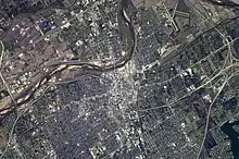
Downtown skyline from Burnett's Mound Kansas State Capitol Constitution Hall | |
 Flag | |
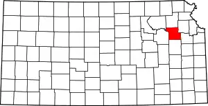
 Location within Shawnee County and Kansas | |
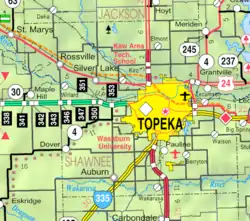
 KDOT map of Shawnee County (legend) | |
| Coordinates: 39°03′N 95°41′W[1] | |
| Country | United States |
| State | Kansas |
| County | Shawnee |
| Founded | 1854 |
| Incorporated | 1857 |
| Government | |
| • Type | Council-Manager |
| • Mayor | Mike Padilla (D)[2] |
| • City Manager | Stephen Wade [3] |
| Area | |
| • State capital city | 62.76 sq mi (162.54 km2) |
| • Land | 61.45 sq mi (159.15 km2) |
| • Water | 1.31 sq mi (3.39 km2) |
| Elevation | 938 ft (286 m) |
| Population | |
| • State capital city | 126,587 |
| • Rank | US: 222nd KS: 5th |
| • Density | 2,000/sq mi (780/km2) |
| • Urban | 150,003 (US: 217th) |
| • Metro | 232,670 (US: 200th) |
| Demonym | Topekan |
| Time zone | UTC-6 (CST) |
| • Summer (DST) | UTC-5 (CDT) |
| ZIP Codes | 66601–66612, 66614–66622, 66624–66626, 66628–66629, 66636–66637, 66642, 66647, 66652–66653, 66667, 66675, 66683, 66692, 66699[7] |
| Area code | 785 |
| FIPS code | 20-71000 |
| GNIS ID | 485655[1] |
| Website | topeka.org |
Topeka was established in 1854 when nine white men founded the Topeka Town Association.[9] At an election in November 1861, the people of Kansas chose Topeka as the permanent capital of the state.[10]
Naming history
The name Topeka is made up of three words from the Kaw, Omaha, and Iowa Native American tribes. The first, to, means "potato". The second, pe (short for pekae) is an adjective meaning "good". The third, okae, means "to dig". Thus, the name Topeka means "a good place to dig potatoes".[11] The name was chosen because "[i]t was a novel name of Indian origin, euphonious [pleasing] of sound and simple".[12]
History and culture
Charles Sheldon and Charles Fox Parham, both important people in the history of American Christianity, were preachers in Topeka. Many historians believe that the modern Pentecostalism movement started in Monroe's church in 1901. Sheldon was a preacher in Topeka around the same time, who is famous for coming up with the phrase "What would Jesus do?"[13]
Brown v. Board of Education of Topeka was a lawsuit that went before the United States Supreme Court in 1954. Several families sued the public school board in Topeka for the right for black students to go to the same schools as white students. The Supreme Court decided that school districts could not make students go to different schools because of their race. Today, the government has a museum in Topeka about Brown v. Board of Education and civil rights for African-Americans.
Geography

Topeka is at 39°03′N 95°41′W,[1] in north east Kansas. It is at the intersection of I-70 and U.S. Highway 75. It is the start of I-335 which is a part of the Kansas Turnpike running from Topeka to Emporia, Kansas. Topeka is also on U.S. Highway 24 (about 50 miles east of Manhattan, Kansas) and U.S. Highway 40 (about 30 miles west of Lawrence, Kansas). U.S.-40 is coincident with I-70 west from Topeka. The United States Census Bureau says that the city has a total area of 62.76 square miles (162.55 km2). Of that, 61.45 square miles (159.15 km2) is land and 1.31 square miles (3.39 km2) is water.[4]
Weather
In 2007 Forbes Magazine saidd Topeka as one of the leading U.S. cities in terms of having the biggest changes in temperature, precipitation, and wind.[14] Topeka has a humid continental climate (Köppen climate classification Dfa). It has hot, somewhat humid summers and cool to cold, fairly dry winters. It is in USDA Plant Hardiness Zone 6.[15] Over the course of a year, the monthly daily average temperature ranges from 29.7 °F (−1.3 °C) in January to 79.0 °F (26.1 °C) in July. The high temperature reaches 90 °F or 32.2 °C on average of 41.5 afternoons per year. The high reaches 100 °F or 37.8 °C an average of 3.5 afternoons per year. The low temperature falls below 0 °F or −17.8 °C on average of four mornings per year, and there are 21 afternoons per year that stay below freezing.[16] The general time of year for freezing temperatures is October 15 through April 17.[16]
The area gets about 36.5 inches (930 mm) of precipitation during an average year. The most being received in May and June—the April through June period averages 33 days of measurable precipitation. Generally, the spring and summer months have the most rainfall. Autumn and winter are fairly dry. During a typical year the total amount of precipitation may be anywhere from 25 to 47 inches (640 to 1,190 mm). Much of the rainfall is comes from thunderstorms. These can be very bad. They often have lightning, big hail, and sometimes tornadoes. Winter snowfall averages almost 17.8 inches or 0.45 metres. Measurable (≥0.1 inches or 0.0025 metres) snowfall occurs an average of 12.9 days per year, with at least one inch (0.025 metre) of snow being received on five of those days. Snow depth of at least an inch happens an average of 20 days per year.[16]
| Climate data for Topeka Regional Airport, Kansas (1981−2010 normals, extremes 1887−present)[lower-alpha 1] | |||||||||||||
|---|---|---|---|---|---|---|---|---|---|---|---|---|---|
| Month | Jan | Feb | Mar | Apr | May | Jun | Jul | Aug | Sep | Oct | Nov | Dec | Year |
| Record high °F (°C) | 77 (25) |
84 (29) |
93 (34) |
97 (36) |
103 (39) |
109 (43) |
114 (46) |
113 (45) |
110 (43) |
97 (36) |
85 (29) |
77 (25) |
114 (46) |
| Average high °F (°C) | 39.9 (4.4) |
45.0 (7.2) |
56.4 (13.6) |
66.7 (19.3) |
75.9 (24.4) |
84.7 (29.3) |
89.5 (31.9) |
88.6 (31.4) |
80.4 (26.9) |
68.4 (20.2) |
54.6 (12.6) |
41.7 (5.4) |
66.0 (18.9) |
| Daily mean °F (°C) | 29.7 (−1.3) |
34.4 (1.3) |
44.8 (7.1) |
55.1 (12.8) |
65.0 (18.3) |
74.2 (23.4) |
79.0 (26.1) |
77.4 (25.2) |
68.3 (20.2) |
56.6 (13.7) |
43.8 (6.6) |
32.0 (0.0) |
55.0 (12.8) |
| Average low °F (°C) | 19.6 (−6.9) |
23.8 (−4.6) |
33.3 (0.7) |
43.5 (6.4) |
54.2 (12.3) |
63.7 (17.6) |
68.4 (20.2) |
66.2 (19.0) |
56.3 (13.5) |
44.7 (7.1) |
33.0 (0.6) |
22.3 (−5.4) |
44.1 (6.7) |
| Record low °F (°C) | −23 (−31) |
−25 (−32) |
−7 (−22) |
10 (−12) |
26 (−3) |
36 (2) |
43 (6) |
40 (4) |
29 (−2) |
16 (−9) |
−5 (−21) |
−26 (−32) |
−26 (−32) |
| Average precipitation inches (mm) | 0.86 (22) |
1.32 (34) |
2.49 (63) |
3.53 (90) |
4.91 (125) |
5.40 (137) |
3.82 (97) |
4.24 (108) |
3.66 (93) |
3.03 (77) |
1.85 (47) |
1.35 (34) |
36.46 (926) |
| Average snowfall inches (cm) | 4.9 (12) |
4.5 (11) |
1.6 (4.1) |
0.3 (0.76) |
0 (0) |
0 (0) |
0 (0) |
0 (0) |
0 (0) |
0.3 (0.76) |
1.0 (2.5) |
5.2 (13) |
17.8 (45) |
| Average precipitation days (≥ 0.01 in) | 5.5 | 6.3 | 9.0 | 9.7 | 11.6 | 11.5 | 8.7 | 8.6 | 7.8 | 8.1 | 6.8 | 6.0 | 99.6 |
| Average snowy days (≥ 0.1 in) | 3.6 | 2.9 | 1.3 | 0.3 | 0 | 0 | 0 | 0 | 0 | 0 | 1.2 | 3.4 | 12.7 |
| Average relative humidity (%) | 69.7 | 69.2 | 65.8 | 64.1 | 68.5 | 71.2 | 69.9 | 70.8 | 72.4 | 68.0 | 70.8 | 72.3 | 69.4 |
| Mean monthly sunshine hours | 177.4 | 168.8 | 212.6 | 231.7 | 268.5 | 293.0 | 326.9 | 291.7 | 233.4 | 212.4 | 157.8 | 150.5 | 2,724.7 |
| Percent possible sunshine | 59 | 56 | 57 | 58 | 60 | 66 | 72 | 69 | 63 | 61 | 52 | 51 | 61 |
| Source: NOAA (relative humidity and sun 1961–1990),[16][17][18] Weather.com[19] | |||||||||||||
People
| Historical population | |||
|---|---|---|---|
| Census | Pop. | %± | |
| 1860 | 759 | — | |
| 1870 | 5,790 | 662.8% | |
| 1880 | 15,452 | 166.9% | |
| 1890 | 31,007 | 100.7% | |
| 1900 | 33,608 | 8.4% | |
| 1910 | 43,684 | 30.0% | |
| 1920 | 50,022 | 14.5% | |
| 1930 | 64,120 | 28.2% | |
| 1940 | 67,833 | 5.8% | |
| 1950 | 78,791 | 16.2% | |
| 1960 | 119,484 | 51.6% | |
| 1970 | 125,011 | 4.6% | |
| 1980 | 115,266 | −7.8% | |
| 1990 | 119,883 | 4.0% | |
| 2000 | 122,377 | 2.1% | |
| 2010 | 127,473 | 4.2% | |
| 2020 | 126,587 | −0.7% | |
| U.S. Decennial Census[20] 2010-2020[6] | |||
2020 census
The 2020 census says that there were 126,587 people, 53,938 households, and 29,912 families living in Topeka. Of the households, 54.8% owned their home and 45.2% rented their home.
The median age was 38.3 years. Of the people, 68.4% were White, 10.4% were Black, 1.6% were Asian, 1.4% were Native American, 0.1% were Pacific Islanders, 6.1% were from some other race, and 11.9% were two or more races. Hispanic or Latino of any race were 16.4% of the people.[5][21]
2010 census
The 2010 census says that there were 127,473 people, 53,943 households, and 30,707 families living in Topeka.[22]
Crime
| Topeka | |
|---|---|
| Crime rates* (2016) | |
| Violent crimes | |
| Homicide | 27 |
| Robbery | 269 |
| Aggravated assault | 425 |
| Total violent crime | 777 |
| Property crimes | |
| Burglary | 1,001 |
| Larceny-theft | 4,725 |
| Motor vehicle theft | 768 |
| Arson | 11 |
| Total property crime | 6,494 |
Notes *Number of reported crimes per 100,000 population. 2017 population: 126,624 Source: | |
Culture
Sports
| Club | Sport | League |
|---|---|---|
| Kaw Valley FC | Soccer | USL League Two |
| Topeka Golden Giants | Baseball | Mid-Plains League |
| Topeka Pilots | Ice hockey | North American Hockey League |
Media
Print
The Topeka Capital-Journal is a newspaper that is published every day. The Topeka Metro News is a newspaper that is published twice per week. Both newspapers have online versions (The Topeka Metro News - Online Edition and CJOnline).
Radio
The following radio stations are licensed to Topeka:
AM
| Frequency | Callsign[27] | Format[28] | Notes |
|---|---|---|---|
| 580 | WIBW | News/Talk | |
| 1440 | KMAJ | News/Talk | |
| 1490 | KTOP | Sports |
FM
| Frequency | Callsign[29] | Format[28] | Notes |
|---|---|---|---|
| 88.1 | KJTY | Contemporary Christian | |
| 89.5 | K208FE | Christian | Translator of KAWZ, Twin Falls, Idaho |
| 90.3 | KBUZ | Christian | AFR |
| 94.5 | WIBW-FM | Country | |
| 99.3 | KWIC | Classic Hits | |
| 100.3 | KDVV | AOR | |
| 106.9 | KTPK | Classic Country | |
| 107.7 | KMAJ | Adult contemporary |
Infrastructure
Transportation
Greyhound Lines has buses going towards Denver, Colorado, eastward to Kansas City, Missouri, and southwest to Wichita, Kansas.[31]
Related pages
Notes
- Official records for Topeka kept at the Weather Bureau Office from June 1887 to July 1946, and at Topeka Regional Airport since August 1946. For more information, see Threadex
References
- U.S. Geological Survey Geographic Names Information System: Topeka, Kansas
- "Mayor - City of Topeka". www.topeka.org. Archived from the original on 2018-07-13. Retrieved 2018-01-22.
- "City of Topeka - Office of the City Manager". Archived from the original on 2 March 2013. Retrieved 26 November 2012.
- "2020 U.S. Gazetteer Files". United States Census Bureau. Retrieved December 12, 2023.
- "DP1: PROFILE OF GENERAL POPULATION AND HOUSING CHARACTERISTICS". United States Census Bureau. Retrieved December 12, 2023.
- "QuickFacts: Topeka city, Kansas". United States Census Bureau. Retrieved December 13, 2023.
- "USPS - Look Up a ZIP Code". United States Postal Service. 2012. Archived from the original on May 25, 2019. Retrieved February 15, 2012.
- The Tormont Webster's Illustrated Encyclopedic Dictionary. United States of America: Tormont Publications Inc. 1990. p. 918. ISBN 2921171325. Retrieved March 11, 2011.
- "Papan Ferry History, Topeka, Kansas". washburn.edu. 2010. Retrieved March 13, 2011.
- Arnold, Anna Estelle (1914). A history of Kansas. State of Kansas. p. 215. Retrieved March 15, 2011.
- Giles, Frye William (1886). Thirty years in Topeka: a historical sketch. G. W. Crane & Co. pp. 54, 55. ISBN 9780598280701. Retrieved February 23, 2011.
- Rydjord, John (1968). Indian place-names: their origin, evolution, and meanings, collected in Kansas from the Siouan, Algonquian, Shoshonean, Caddoan, Iroquoian, and other tongues. University of Oklahoma Press. p. 155.
- Alan F. Bearman and Jennifer L. Mills 2009. "Adapting Christianity to the Challenges of the American West", Kansas History: A Journal of the Central Plains, 32(106)
- Tom Van Riper (2007-07-20). "In Pictures: America's Wildest Weather Cities". Forbes.com. Retrieved 2010-04-01.
- The Arbor Day Foundation. "The Arbor Day Foundation". Arborday.org. Archived from the original on 2014-12-14. Retrieved 2013-06-15.
- Team, National Weather Service Corporate Image Web. "National Weather Service Climate". www.nws.noaa.gov.
- "Station Name: KS TOPEKA MUNI AP". National Oceanic and Atmospheric Administration. Retrieved 2014-04-01.
- "WMO Climate Normals for TOPEKA/MUNICIPAL ARPT KS 1961–1990". National Oceanic and Atmospheric Administration. Retrieved 2014-03-11.
- "Monthly Averages for Topeka, KS". The Weather Channel. Retrieved 2011-01-30.
- "U.S. Decennial Census". Census.gov. Retrieved May 30, 2013.
- "P16: HOUSEHOLD TYPE". United States Census Bureau. Retrieved January 2, 2024.
- "American FactFinder". United States Census Bureau. Retrieved July 6, 2012.
- Stern, Jane and Michael (1999). Chili Nation. Broadway Books. p. 58. ISBN 0767902637.
- Stern, Michael. "Porubsky's Grocery". Roadfood.com. Archived from the original on October 16, 2015. Retrieved October 17, 2015.
- Stern, Jane and Michael (February 2008). "A LITTLE CHILI IN KANSAS". Gourmet. Retrieved October 17, 2015.
- Saladino, Emily (March 6, 2014). "America's Best Chili". Travel+Leisure. Retrieved October 17, 2015.
- "AMQ AM Radio Database Query". Federal Communications Commission. Archived from the original on 2009-08-25. Retrieved 2009-09-18.
- "Station Information Profile". Arbitron. Retrieved 2009-09-18.
- "FMQ FM Radio Database Query". Federal Communications Commission. Archived from the original on 2009-08-25. Retrieved 2009-09-18.
- "TVQ TV Database Query". Federal Communications Commission. Archived from the original on 2009-05-08. Retrieved 2009-09-18.
- "Greyhound". www.greyhound.com.

.jpg.webp)

.jpg.webp)
.jpg.webp)

