Ellis County, Kansas
Ellis County (county code EL) is a county in the U.S. state of Kansas. In the 2020 census, 28,934 people lived there.[1] The county seat and biggest city is Hays.[2]
Ellis County | |
|---|---|
 Ellis County Courthouse in Hays (1979) | |
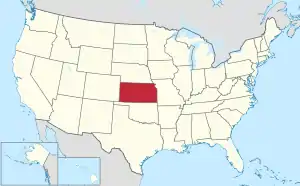
 Location within the U.S. state of Kansas | |
 Kansas's location within the U.S. | |
| Coordinates: 38°55′N 99°19′W | |
| Country | |
| State | |
| Founded | 1867 |
| Named for | George Ellis |
| Seat | Hays |
| Largest city | Hays |
| Area | |
| • Total | 900 sq mi (2,000 km2) |
| • Land | 899 sq mi (2,330 km2) |
| • Water | 0.5 sq mi (1 km2) 0.05% |
| Population | |
| • Total | 28,934 |
| • Density | 32.2/sq mi (12.4/km2) |
| Time zone | UTC−6 (Central) |
| • Summer (DST) | UTC−5 (CDT) |
| Area code | 785 |
| Congressional district | 1st |
| Website | ellisco.net |
History
Ellis County was created on February 26, 1867.
Geography
The U.S. Census Bureau says that the county has a total area of 900 square miles (2,300 km2). Of that 900 square miles (2,300 km2) is land and 0.5 square miles (1.3 km2) (0.05%) is water.[3]
Bordering counties
- Rooks County (north)
- Osborne County (northeast)
- Russell County (east)
- Rush County (south)
- Ness County (southwest)
- Trego County (west)
Major highways
 Interstate 70
 US-183
People
| Historical population | |||
|---|---|---|---|
| Census | Pop. | %± | |
| 1870 | 1,336 | — | |
| 1880 | 6,179 | 362.5% | |
| 1890 | 7,942 | 28.5% | |
| 1900 | 8,626 | 8.6% | |
| 1910 | 12,170 | 41.1% | |
| 1920 | 14,138 | 16.2% | |
| 1930 | 15,907 | 12.5% | |
| 1940 | 17,508 | 10.1% | |
| 1950 | 19,043 | 8.8% | |
| 1960 | 21,270 | 11.7% | |
| 1970 | 24,730 | 16.3% | |
| 1980 | 26,098 | 5.5% | |
| 1990 | 26,004 | −0.4% | |
| 2000 | 27,507 | 5.8% | |
| 2010 | 28,452 | 3.4% | |
| 2020 | 28,934 | 1.7% | |
| U.S. Decennial Census[4] 1790-1960[5] 1900-1990[6] 1990-2000[7] 2010-2020[1] | |||

The Hays Micropolitan Statistical Area includes all of Ellis County.
Government
| Year | Republican | Democratic | Third Parties |
|---|---|---|---|
| 2020 | 70.4% 9,758 | 27.0% 3,737 | 2.6% 361 |
| 2016 | 70.2% 8,466 | 22.7% 2,742 | 7.1% 854 |
| 2012 | 71.7% 8,399 | 26.1% 3,057 | 2.2% 258 |
| 2008 | 65.9% 8,207 | 32.2% 4,010 | 1.9% 230 |
| 2004 | 64.8% 7,891 | 33.1% 4,033 | 2.2% 263 |
| 2000 | 58.4% 6,516 | 35.2% 3,926 | 6.4% 718 |
| 1996 | 57.0% 6,809 | 34.7% 4,142 | 8.4% 1,001 |
| 1992 | 32.0% 3,985 | 36.5% 4,544 | 31.5% 3,924 |
| 1988 | 48.7% 5,194 | 49.6% 5,289 | 1.8% 189 |
| 1984 | 67.7% 7,509 | 31.2% 3,457 | 1.2% 133 |
| 1980 | 52.5% 5,634 | 36.7% 3,940 | 10.7% 1,150 |
| 1976 | 42.0% 4,719 | 55.9% 6,280 | 2.1% 241 |
| 1972 | 55.7% 5,463 | 41.9% 4,113 | 2.4% 237 |
| 1968 | 46.7% 3,944 | 45.1% 3,809 | 8.2% 688 |
| 1964 | 30.4% 2,440 | 69.2% 5,553 | 0.3% 27 |
| 1960 | 35.2% 3,156 | 64.8% 5,815 | 0.1% 6 |
| 1956 | 59.3% 4,466 | 40.6% 3,058 | 0.1% 4 |
| 1952 | 65.9% 4,882 | 34.1% 2,528 | 0.0% 3 |
| 1948 | 40.5% 2,676 | 58.5% 3,863 | 1.0% 67 |
| 1944 | 60.1% 3,369 | 39.6% 2,218 | 0.3% 16 |
| 1940 | 52.2% 3,622 | 47.5% 3,299 | 0.4% 25 |
| 1936 | 25.1% 1,622 | 74.7% 4,834 | 0.2% 13 |
| 1932 | 24.5% 1,465 | 74.5% 4,449 | 0.9% 56 |
| 1928 | 33.5% 1,700 | 66.3% 3,364 | 0.2% 11 |
| 1924 | 46.4% 1,763 | 22.2% 842 | 31.5% 1,197 |
| 1920 | 75.2% 2,385 | 23.3% 740 | 1.5% 48 |
| 1916 | 32.9% 1,186 | 64.7% 2,335 | 2.4% 87 |
| 1912 | 8.2% 175 | 64.9% 1,381 | 26.9% 573 |
| 1908 | 34.5% 768 | 63.8% 1,421 | 1.7% 37 |
| 1904 | 51.1% 1,009 | 47.0% 928 | 2.0% 39 |
| 1900 | 33.6% 627 | 65.7% 1,228 | 0.8% 14 |
| 1896 | 30.0% 460 | 68.6% 1,051 | 1.4% 22 |
| 1892 | 33.5% 546 | 66.5% 1,083 | |
| 1888 | 44.4% 690 | 48.7% 756 | 6.9% 107 |
Education
Unified school districts
- Ellis USD 388
- western third of county; small portion in extreme eastern Trego County
- Victoria USD 432
- eastern third of county to Russell county line
- Hays USD 489
Private schools
Colleges and Universities
Communities

Census-designated places
- Catharine
- Munjor
Other unincorporated places

- Antonino
- Emmeram
- Pfeifer
- Toulon
- Turkville
- Walker
- Yocemento
Defunct settlements
- Chetolah
- Hog Back
- Rome
- Smoky Hill City
- Stockrange
Townships
Ellis County is divided into nine townships. The cities of Ellis and Hays are considered governmentally independent and are excluded from the census figures for the townships. In the following table, the population center is the largest city (or cities) included in that township's population total, if it is of a significant size.
| Township | FIPS | Population center |
Population (2020) | Population density /km² (/sq mi) |
Land area km² (sq mi) | Water area km² (sq mi) | Water % | Geographic coordinates |
|---|---|---|---|---|---|---|---|---|
| Big Creek | 06650 | 2,077 | 8 (22) | 249 (96) | 0 (0) | 0.01% | 38°52′2″N 99°21′54″W | |
| Buckeye | 08950 | 391 | 1 (3) | 352 (136) | 0 (0) | 0.05% | 39°1′35″N 99°20′19″W | |
| Catherine | 11050 | 281 | 1 (3) | 208 (80) | 0 (0) | 0.03% | 39°1′25″N 99°11′43″W | |
| Ellis | 20475 | 452 | 1 (3) | 456 (176) | 0 (0) | 0.02% | 38°59′41″N 99°30′38″W | |
| Freedom | 24625 | 106 | 1 (2) | 117 (45) | 0 (0) | 0% | 38°44′0″N 99°7′31″W | |
| Herzog | 31525 | 839 | 3 (7) | 325 (126) | 1 (0) | 0.18% | 38°59′19″N 99°6′44″W | |
| Lookout | 42700 | 523 | 2 (4) | 317 (122) | 0 (0) | 0.08% | 38°45′37″N 99°27′11″W | |
| Victoria | 73800 | 804 | 6 (15) | 139 (54) | 0 (0) | 0% | 38°48′46″N 99°7′25″W | |
| Wheatland | 77650 | 387 | 3 (7) | 140 (54) | 0 (0) | 0% | 38°45′44″N 99°15′50″W |
References
- "QuickFacts: Ellis County, Kansas". United States Census Bureau. Retrieved October 1, 2023.
- "Find a County". National Association of Counties. Archived from the original on 2011-05-31. Retrieved 2011-06-07.
- "US Gazetteer files: 2010, 2000, and 1990". United States Census Bureau. 2011-02-12. Retrieved 2011-04-23.
- "U.S. Decennial Census". United States Census Bureau. Archived from the original on April 26, 2015. Retrieved July 24, 2014.
- "Historical Census Browser". University of Virginia Library. Archived from the original on August 11, 2012. Retrieved July 24, 2014.
- "Population of Counties by Decennial Census: 1900 to 1990". United States Census Bureau. Retrieved July 24, 2014.
- "Census 2000 PHC-T-4. Ranking Tables for Counties: 1990 and 2000" (PDF). United States Census Bureau. Retrieved July 24, 2014.
- "Dave Leip's Atlas of U.S. Presidential Elections".
Other websites
- County
- Maps
- Ellis County Maps: Current, Historic, KDOT
- Kansas Highway Maps: Current, Historic, KDOT
- Kansas Railroad Maps: Current, 1996, 1915, KDOT and Kansas Historical Society
Places next to Ellis County, Kansas | ||||||||||
|---|---|---|---|---|---|---|---|---|---|---|
| ||||||||||
Municipalities and communities of Ellis County, Kansas, United States | ||
|---|---|---|
| Cities | Map of Kansas highlighting Ellis County | |
| Unincorporated communities |
| |
| Ghost towns |
| |
| Townships |
| |
| Footnotes | †This community is designated a Census-Designated Place (CDP) by the United States Census Bureau. | |