Nemaha County, Kansas
Nemaha County (standard abbreviation: NM) is a county in the northeastern part of the U.S. state of Kansas. In 2020, 10,273 people lived there.[1] The county seat is Seneca.[2]
Nemaha County | |
|---|---|
 Jail and sheriff residence in Seneca (2015) | |
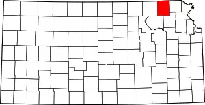 Location within the U.S. state of Kansas | |
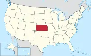 Kansas's location within the U.S. | |
| Coordinates: 39°48′N 96°01′W | |
| Country | |
| State | |
| Founded | August 25, 1855 |
| Named for | Nemaha River |
| Seat | Seneca |
| Largest city | Sabetha |
| Area | |
| • Total | 719 sq mi (1,860 km2) |
| • Land | 717 sq mi (1,860 km2) |
| • Water | 2.0 sq mi (5 km2) 0.3% |
| Population | |
| • Total | 10,273 |
| • Density | 14.3/sq mi (5.5/km2) |
| Time zone | UTC−6 (Central) |
| • Summer (DST) | UTC−5 (CDT) |
| Area code | 785 |
| Congressional district | 2nd |
| Website | www |
History
In 1855, Nemaha County was created.
The first railroad in Nemaha County was built in 1866.[3]
On May 30, 1879, the "Irving, Kansas Tornado" went through Nemaha county. This tornado measured F4 on the Fujita scale. It had a damage path 800 yards (730 m) wide and 100 miles (160 km) long. Eighteen people were killed and sixty were injured in this tornado.
Geography
The U.S. Census Bureau says that the county has a total area of 719 square miles (1,860 km2). Of that, 717 square miles (1,860 km2) is land and 2.0 square miles (5.2 km2) (0.3%) is water.[4]
People
| Historical population | |||
|---|---|---|---|
| Census | Pop. | %± | |
| 1860 | 2,436 | — | |
| 1870 | 7,339 | 201.3% | |
| 1880 | 12,462 | 69.8% | |
| 1890 | 19,249 | 54.5% | |
| 1900 | 20,376 | 5.9% | |
| 1910 | 19,072 | −6.4% | |
| 1920 | 18,487 | −3.1% | |
| 1930 | 18,342 | −0.8% | |
| 1940 | 16,761 | −8.6% | |
| 1950 | 14,341 | −14.4% | |
| 1960 | 12,897 | −10.1% | |
| 1970 | 11,825 | −8.3% | |
| 1980 | 11,211 | −5.2% | |
| 1990 | 10,446 | −6.8% | |
| 2000 | 10,717 | 2.6% | |
| 2010 | 10,178 | −5.0% | |
| 2020 | 10,273 | 0.9% | |
| U.S. Decennial Census[5] 1790-1960[6] 1900-1990[7] 1990-2000[8] 2010-2020[1] | |||

Age pyramid
Government
Presidential elections
Presidential Elections Results
| Year | Republican | Democratic | Third Parties |
|---|---|---|---|
| 2020 | 82.1% 4,664 | 16.3% 927 | 1.6% 93 |
| 2016 | 80.5% 4,124 | 14.2% 725 | 5.3% 273 |
| 2012 | 78.2% 3,930 | 19.9% 1,000 | 1.9% 96 |
| 2008 | 71.2% 3,817 | 26.7% 1,432 | 2.1% 110 |
| 2004 | 73.7% 4,027 | 24.8% 1,355 | 1.5% 81 |
| 2000 | 67.6% 3,578 | 28.2% 1,494 | 4.1% 218 |
| 1996 | 56.1% 3,014 | 30.7% 1,648 | 13.3% 713 |
| 1992 | 39.5% 2,220 | 28.1% 1,580 | 32.4% 1,819 |
| 1988 | 55.0% 2,849 | 43.6% 2,261 | 1.4% 72 |
| 1984 | 66.6% 3,653 | 32.1% 1,761 | 1.3% 71 |
| 1980 | 65.0% 3,546 | 29.3% 1,600 | 5.7% 310 |
| 1976 | 50.7% 2,759 | 47.5% 2,586 | 1.8% 96 |
| 1972 | 64.1% 3,422 | 33.3% 1,777 | 2.7% 143 |
| 1968 | 54.0% 3,003 | 34.6% 1,925 | 11.4% 632 |
| 1964 | 42.1% 2,391 | 57.4% 3,260 | 0.6% 32 |
| 1960 | 53.6% 3,360 | 46.0% 2,884 | 0.4% 23 |
| 1956 | 67.1% 4,195 | 32.6% 2,038 | 0.3% 18 |
| 1952 | 76.0% 5,175 | 23.8% 1,618 | 0.3% 19 |
| 1948 | 55.4% 3,529 | 44.1% 2,810 | 0.5% 32 |
| 1944 | 66.4% 4,277 | 33.4% 2,149 | 0.2% 11 |
| 1940 | 65.6% 5,178 | 34.0% 2,679 | 0.4% 32 |
| 1936 | 47.8% 3,903 | 51.1% 4,175 | 1.2% 94 |
| 1932 | 40.6% 3,167 | 58.7% 4,578 | 0.7% 55 |
| 1928 | 61.1% 4,639 | 38.5% 2,919 | 0.5% 34 |
| 1924 | 60.2% 4,096 | 27.2% 1,846 | 12.6% 857 |
| 1920 | 72.3% 4,655 | 26.9% 1,731 | 0.8% 51 |
| 1916 | 49.2% 3,591 | 49.0% 3,579 | 1.8% 130 |
| 1912 | 22.2% 961 | 44.7% 1,936 | 33.1% 1,433 |
| 1908 | 51.6% 2,394 | 47.0% 2,182 | 1.4% 66 |
| 1904 | 61.9% 2,764 | 35.0% 1,564 | 3.0% 135 |
| 1900 | 53.5% 2,761 | 45.5% 2,348 | 1.1% 57 |
| 1896 | 50.5% 2,568 | 48.7% 2,478 | 0.8% 40 |
| 1892 | 49.7% 2,222 | 50.3% 2,246[lower-alpha 1] | |
| 1888 | 56.5% 2,515 | 37.8% 1,682 | 5.6% 251 |
Education
Unified school districts
- Prairie Hills USD 113 - Bern, Sabetha, Wetmore, (Axtell and Summerfield in Marshall County). USD 441 and USD 488 merged to create USD 113 in 2010.
- Nemaha Central USD 115 - Baileyville, Seneca, St. Benedict. USD 442 and USD 451 merged to create USD 115 in 2011.[10]
- Vermillion USD 380 - Centralia, (Frankfort in Marshall County)
Communities
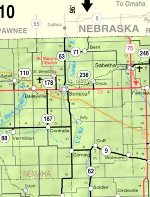
2005 KDOT Map of Nemaha County (map legend)
References
- "QuickFacts: Nemaha County, Kansas". United States Census Bureau. Retrieved October 3, 2023.
- "Find a County". National Association of Counties. Retrieved 2011-06-07.
- Blackmar, Frank Wilson (1912). Kansas: A Cyclopedia of State History, Volume 2. Standard Publishing Company. p. 345.
- "US Gazetteer files: 2010, 2000, and 1990". United States Census Bureau. 2011-02-12. Retrieved 2011-04-23.
- "U.S. Decennial Census". United States Census Bureau. Retrieved July 27, 2014.
- "Historical Census Browser". University of Virginia Library. Archived from the original on August 11, 2012. Retrieved July 27, 2014.
- "Population of Counties by Decennial Census: 1900 to 1990". United States Census Bureau. Retrieved July 27, 2014.
- "Census 2000 PHC-T-4. Ranking Tables for Counties: 1990 and 2000" (PDF). United States Census Bureau. Retrieved July 27, 2014.
- "Dave Leip's Atlas of U.S. Presidential Elections".
- Nemaha County School Districts Merge To Form USD 115
- Notes
- 2,194 votes (49.10 percent) were for Populist James B. Weaver (who was supported by the state’s Democrats) and 52 (1.16 percent) for Prohibition Party candidate John Bidwell.
More reading
- Atlas of Nemaha County, Kansas; Anderson Publishing Co; 62 pages; 1922.
- Plat Book of Nemaha County, Kansas; A.R. Stinson; 53 pages; 1908.
Other websites
Wikimedia Commons has media related to Nemaha County, Kansas.
- County
- Other information
- Maps
- Nemaha County Maps: Current, Historic, KDOT
- Kansas Highway Maps: Current, Historic, KDOT
- Kansas Railroad Maps: Current, 1996, 1915, KDOT and Kansas Historical Society
This article is issued from Wikipedia. The text is licensed under Creative Commons - Attribution - Sharealike. Additional terms may apply for the media files.