Wichita County, Kansas
Wichita County (standard abbreviation: WH) is a county in the U.S. state of Kansas. In 2020 census, 2,152 people lived there.[1] Its county seat is Leoti.[2]
Wichita County | |
|---|---|
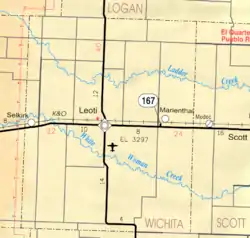
 Wichita County courthouse in Leoti (2015) | |
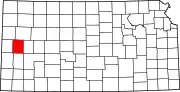 Location within the U.S. state of Kansas | |
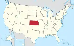 Kansas's location within the U.S. | |
| Coordinates: 38°28′00″N 101°21′00″W | |
| Country | |
| State | |
| Founded | December 24, 1886 |
| Named for | Wichita tribe |
| Seat | Leoti |
| Largest city | Leoti |
| Area | |
| • Total | 719 sq mi (1,860 km2) |
| • Land | 719 sq mi (1,860 km2) |
| • Water | 0.02 sq mi (0.05 km2) 0.0% |
| Population | |
| • Total | 2,152 |
| • Density | 3.0/sq mi (1.2/km2) |
| Time zone | UTC−6 (Central) |
| • Summer (DST) | UTC−5 (CDT) |
| Congressional district | 1st |
| Website | WichitaCounty.org |
History
19th century
In 1886, Wichita County was created.
Geography
The U.S. Census Bureau says that the county has a total area of 719 square miles (1,860 km2). All of it is land.[3]
Major highways
 Kansas Highway 25
 Kansas Highway 96
People
| Historical population | |||
|---|---|---|---|
| Census | Pop. | %± | |
| 1880 | 14 | — | |
| 1890 | 1,827 | 12,950.0% | |
| 1900 | 1,197 | −34.5% | |
| 1910 | 2,006 | 67.6% | |
| 1920 | 1,856 | −7.5% | |
| 1930 | 2,579 | 39.0% | |
| 1940 | 2,185 | −15.3% | |
| 1950 | 2,640 | 20.8% | |
| 1960 | 2,765 | 4.7% | |
| 1970 | 3,274 | 18.4% | |
| 1980 | 3,041 | −7.1% | |
| 1990 | 2,758 | −9.3% | |
| 2000 | 2,531 | −8.2% | |
| 2010 | 2,234 | −11.7% | |
| 2020 | 2,152 | −3.7% | |
| U.S. Decennial Census[4] 1790-1960[5] 1900-1990[6] 1990-2000[7] 2010-2020[1] | |||

Age pyramid
Government
Presidential elections
Presidential Elections Results
| Year | Republican | Democratic | Third Parties |
|---|---|---|---|
| 2020 | 83.5% 808 | 15.4% 149 | 1.1% 11 |
| 2016 | 80.4% 769 | 14.6% 140 | 4.9% 47 |
| 2012 | 83.2% 821 | 15.9% 157 | 0.9% 9 |
| 2008 | 82.4% 840 | 16.0% 163 | 1.6% 16 |
| 2004 | 81.8% 869 | 17.2% 183 | 0.9% 10 |
| 2000 | 78.8% 859 | 19.0% 207 | 2.2% 24 |
| 1996 | 71.1% 796 | 21.4% 239 | 7.5% 84 |
| 1992 | 55.4% 681 | 19.6% 241 | 25.0% 308 |
| 1988 | 62.8% 721 | 34.8% 399 | 2.4% 28 |
| 1984 | 78.9% 916 | 20.0% 232 | 1.1% 13 |
| 1980 | 70.0% 880 | 24.1% 303 | 6.0% 75 |
| 1976 | 47.9% 593 | 49.6% 614 | 2.5% 31 |
| 1972 | 69.9% 794 | 25.4% 288 | 4.8% 54 |
| 1968 | 60.4% 757 | 29.0% 364 | 10.6% 133 |
| 1964 | 44.2% 529 | 55.3% 662 | 0.5% 6 |
| 1960 | 55.6% 702 | 43.9% 554 | 0.5% 6 |
| 1956 | 70.4% 747 | 29.4% 312 | 0.2% 2 |
| 1952 | 75.9% 910 | 23.0% 276 | 1.1% 13 |
| 1948 | 56.3% 606 | 41.1% 443 | 2.6% 28 |
| 1944 | 64.3% 604 | 35.0% 329 | 0.6% 6 |
| 1940 | 59.1% 644 | 39.7% 433 | 1.2% 13 |
| 1936 | 41.1% 448 | 58.4% 637 | 0.6% 6 |
| 1932 | 32.9% 375 | 64.3% 732 | 2.8% 32 |
| 1928 | 54.9% 464 | 43.8% 370 | 1.3% 11 |
| 1924 | 62.7% 482 | 19.1% 147 | 18.2% 140 |
| 1920 | 73.9% 422 | 22.2% 127 | 3.9% 22 |
| 1916 | 44.0% 318 | 46.1% 333 | 9.8% 71 |
| 1912 | 22.1% 82 | 36.4% 135 | 41.5% 154[lower-alpha 1] |
| 1908 | 54.3% 233 | 40.3% 173 | 5.4% 23 |
| 1904 | 67.3% 245 | 25.0% 91 | 7.7% 28 |
| 1900 | 60.4% 201 | 38.4% 128 | 1.2% 4 |
| 1896 | 52.3% 214 | 46.9% 192 | 0.7% 3 |
| 1892 | 53.3% 245 | 46.7% 215 | |
| 1888 | 59.4% 438 | 28.1% 207 | 12.6% 93 |
Wichita County is very Republican. The last Democrat to win the county was Jimmy Carter in 1976. In the past six elections no Democrat has won more than twenty percent of Wichita County’s vote.
Laws
Although the Kansas Constitution was changed in 1986 to allow the sale of alcohol, Wichita County is still a "dry" county.[9]
Education
- Leoti USD 467
References
- "QuickFacts: Wichita County, Kansas". United States Census Bureau. Retrieved October 4, 2023.
- "Find a County". National Association of Counties. Retrieved 2011-06-07.
- "US Gazetteer files: 2010, 2000, and 1990". United States Census Bureau. 2011-02-12. Retrieved 2011-04-23.
- "U.S. Decennial Census". United States Census Bureau. Retrieved July 29, 2014.
- "Historical Census Browser". University of Virginia Library. Archived from the original on August 11, 2012. Retrieved July 29, 2014.
- "Population of Counties by Decennial Census: 1900 to 1990". United States Census Bureau. Retrieved July 29, 2014.
- "Census 2000 PHC-T-4. Ranking Tables for Counties: 1990 and 2000" (PDF). United States Census Bureau. Retrieved July 29, 2014.
- "Dave Leip's Atlas of U.S. Presidential Elections".
- "Map of Wet and Dry Counties". Alcoholic Beverage Control, Kansas Department of Revenue. November 2004. Archived from the original on 2007-10-08. Retrieved 2007-01-21.
- Notes
- This comprises 113 votes (30.5%) for Progressive Theodore Roosevelt and 41 votes (11.1%) for Socialist Eugene V. Debs.
More reading
- Standard Atlas of Wichita County, Kansas; Geo. A. Ogle & Co; 60 pages; 1920.
Other websites
Wikimedia Commons has media related to Wichita County, Kansas.
- County
- Maps
- Wichita County Maps: Current, Historic, KDOT
- Kansas Highway Maps: Current, Historic, KDOT
- Kansas Railroad Maps: Current, 1996, 1915, KDOT and Kansas Historical Society
Municipalities and communities of Wichita County, Kansas, United States | ||
|---|---|---|
| City | Map of Kansas highlighting Wichita County | |
| Unincorporated communities |
| |
| Ghost towns |
| |
| Footnotes | †This community is designated a Census-Designated Place (CDP) by the United States Census Bureau. | |
This article is issued from Wikipedia. The text is licensed under Creative Commons - Attribution - Sharealike. Additional terms may apply for the media files.