Marion County, Kansas
Marion County (standard abbreviation: MN) is a county in the U.S. state of Kansas. In 2020, 11,823 people lived there.[1] The county seat is Marion. The county was named after Francis Marion, a Brigadier General of the American Revolutionary War, known as the "Swamp Fox".[2]
Marion County | |
|---|---|
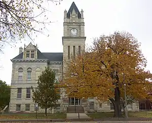 Marion County Courthouse (2009) | |
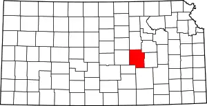 Location within the U.S. state of Kansas | |
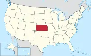 Kansas's location within the U.S. | |
| Coordinates: 38°21′N 97°06′W | |
| Country | |
| State | |
| Founded | August 30, 1855 |
| Named for | Francis Marion |
| Seat | Marion |
| Largest city | Hillsboro |
| Area | |
| • Total | 954 sq mi (2,470 km2) |
| • Land | 944 sq mi (2,440 km2) |
| • Water | 9.4 sq mi (24 km2) 1.0% |
| Population | |
| • Total | 11,823 |
| • Density | 12.5/sq mi (4.8/km2) |
| Time zone | UTC−6 (Central) |
| • Summer (DST) | UTC−5 (CDT) |
| Area code | 620, 785 |
| Congressional district | 2nd |
| Website | marioncoks.net |
History
21st century
In 2010, the Keystone-Cushing Pipeline (Phase II) was built north to south through Marion County. There was a lot of controversy over road damage, tax exemption, and environmental concerns (if a leak ever occurs).[3][4][5][6]
Geography
The U.S. Census Bureau says that the county has a total area of 954 square miles (2,470 km2). Of that, 944 square miles (2,440 km2) is land and 9.4 square miles (24 km2) (1.0%) is water.[7]
Marion County is in the Great Plains. The eastern part of the county is part of the Flint Hills.[8][9]
People
| Historical population | |||
|---|---|---|---|
| Census | Pop. | %± | |
| 1860 | 74 | — | |
| 1870 | 768 | 937.8% | |
| 1880 | 12,453 | 1,521.5% | |
| 1890 | 20,539 | 64.9% | |
| 1900 | 20,676 | 0.7% | |
| 1910 | 22,415 | 8.4% | |
| 1920 | 22,923 | 2.3% | |
| 1930 | 20,739 | −9.5% | |
| 1940 | 18,951 | −8.6% | |
| 1950 | 16,307 | −14.0% | |
| 1960 | 15,143 | −7.1% | |
| 1970 | 13,935 | −8.0% | |
| 1980 | 13,522 | −3.0% | |
| 1990 | 12,888 | −4.7% | |
| 2000 | 13,361 | 3.7% | |
| 2010 | 12,660 | −5.2% | |
| 2020 | 11,823 | −6.6% | |
| U.S. Decennial Census[10] 1790-1960[11] 1900-1990[12] 1990-2000[13] 2010-2020[1] | |||

Government
Presidential elections
| Year | Republican | Democratic | Third Parties |
|---|---|---|---|
| 2020 | 73.1% 4,465 | 24.8% 1,516 | 2.1% 130 |
| 2016 | 70.6% 4,003 | 21.2% 1,204 | 8.2% 463 |
| 2012 | 71.9% 3,889 | 25.6% 1,385 | 2.5% 135 |
| 2008 | 68.6% 4,159 | 29.7% 1,801 | 1.6% 99 |
| 2004 | 73.3% 4,516 | 24.9% 1,536 | 1.7% 107 |
| 2000 | 70.4% 4,156 | 25.0% 1,475 | 4.6% 272 |
| 1996 | 65.3% 4,173 | 26.2% 1,673 | 8.5% 543 |
| 1992 | 49.5% 3,142 | 25.6% 1,627 | 24.9% 1,582 |
| 1988 | 63.0% 3,685 | 34.6% 2,024 | 2.4% 141 |
| 1984 | 72.1% 4,407 | 26.7% 1,632 | 1.3% 77 |
| 1980 | 64.4% 3,960 | 25.5% 1,569 | 10.1% 621 |
| 1976 | 50.7% 3,226 | 47.2% 3,004 | 2.0% 130 |
| 1972 | 72.2% 4,373 | 24.4% 1,478 | 3.4% 208 |
| 1968 | 70.4% 4,287 | 24.5% 1,494 | 5.1% 311 |
| 1964 | 54.9% 3,481 | 44.0% 2,792 | 1.1% 68 |
| 1960 | 73.2% 5,250 | 26.6% 1,904 | 0.3% 18 |
| 1956 | 76.0% 5,318 | 23.5% 1,644 | 0.5% 36 |
| 1952 | 80.2% 6,228 | 17.5% 1,361 | 2.3% 178 |
| 1948 | 64.9% 4,724 | 33.2% 2,421 | 1.9% 140 |
| 1944 | 72.6% 5,219 | 26.8% 1,925 | 0.6% 41 |
| 1940 | 67.4% 5,764 | 31.9% 2,724 | 0.7% 59 |
| 1936 | 49.7% 4,185 | 49.9% 4,207 | 0.4% 34 |
| 1932 | 41.7% 3,220 | 56.6% 4,366 | 1.7% 129 |
| 1928 | 73.5% 5,446 | 26.2% 1,938 | 0.4% 26 |
| 1924 | 56.4% 4,008 | 21.4% 1,520 | 22.2% 1,581 |
| 1920 | 65.8% 3,840 | 29.4% 1,713 | 4.8% 281 |
| 1916 | 52.1% 3,453 | 42.1% 2,790 | 5.7% 379 |
| 1912 | 20.0% 863 | 40.1% 1,732 | 39.9% 1,724 |
| 1908 | 57.5% 2,546 | 39.4% 1,747 | 3.1% 139 |
| 1904 | 71.2% 2,705 | 24.4% 928 | 4.4% 166 |
| 1900 | 59.7% 2,623 | 39.3% 1,729 | 1.0% 44 |
| 1896 | 56.6% 2,285 | 42.1% 1,699 | 1.3% 53 |
| 1892 | 55.5% 2,210 | 44.5% 1,749 | |
| 1888 | 60.2% 2,375 | 32.5% 1,283 | 7.4% 290 |
Education
Unified school districts
- Centre USD 397
- Students in Lincolnville, Lost Springs, Pilsen, Tampa, Ramona, Antelope, rural areas
- Centre High School, in rural area between Lincolnville and Lost Springs
- Peabody-Burns USD 398
- Students in Peabody, Burns, Wonsevu, rural areas
- Peabody-Burns Junior/Senior High School, in Peabody
- Marion USD 408
- Students in Marion, Florence, Eastshore, Canada, Aulne, Marion County Lake, rural areas
- Marion High School, in Marion
- Hillsboro USD 410
- Students in Hillsboro, Lehigh, Durham, rural areas
- Hillsboro High School, in Hillsboro
- Goessel USD 411
- Students in Goessel, rural areas
- Goessel High School, in Goessel
Colleges
- Tabor College, in Hillsboro
- Butler Community College (remote campus), in Marion
Communities
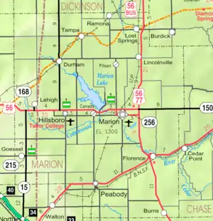
Cities
- Burns (previously known as St. Francis)
- Durham (previously known as Durham Park)
- Florence
- Goessel (previously known as Gnadenfeld)
- Hillsboro (previously known as Hill City)
- Lehigh
- Lincolnville
- Lost Springs
- Marion (previously known as Marion Centre)
- Peabody (previously known as Coneburg)
- Ramona
- Tampa
References
- "QuickFacts: Marion County, Kansas". United States Census Bureau. Retrieved October 1, 2023.
- Gannett, Henry (1905). The Origin of Certain Place Names in the United States. U.S. Government Printing Office. p. 200.
- Keystone Pipeline - Marion County Commission calls out Legislative Leadership on Pipeline Deal; April 18, 2010. Archived October 22, 2011, at the Wayback Machine
- Keystone Pipeline - TransCanada inspecting pipeline; December 10, 2010.
- County and Keystone settle on road damages; Hillsboro Free Press; November 2, 2010.
- Keystone Pipeline - County ask TransCanada for pipeline emergency plan; Hillsboro Free Press; February 15, 2011.
- "US Gazetteer files: 2010, 2000, and 1990". United States Census Bureau. 2011-02-12. Retrieved 2011-04-23.
- "Flint Hills Tourism Coalition". Archived from the original on 2013-08-10. Retrieved 2021-08-06.
- "Flint Hills Introduction; Kansas Geological Survey". Archived from the original on 2009-02-08. Retrieved 2019-07-29.
- "U.S. Decennial Census". United States Census Bureau. Retrieved July 27, 2014.
- "Historical Census Browser". University of Virginia Library. Archived from the original on May 30, 2019. Retrieved July 27, 2014.
- "Population of Counties by Decennial Census: 1900 to 1990". United States Census Bureau. Retrieved July 27, 2014.
- "Census 2000 PHC-T-4. Ranking Tables for Counties: 1990 and 2000" (PDF). United States Census Bureau. Retrieved July 27, 2014.
- Leip, David. "Dave Leip's Atlas of U.S. Presidential Elections". uselectionatlas.org. Retrieved 17 April 2018.
More reading
- County
- Our Nation Called : Marion County Answered - Honoring Our Marion County Kansas Veterans; Hillsboro Free Press; 192 pages; 2012.
- The Days of June : Recollections of a Country Sheriff; Tracy Mayes; Leathers Pub; 72 pages; 1999; ISBN 978-1890622671.
- Touring Marion County : pioneers, lakes, & the mighty Santa Fe; Robert Collins; 1993.
- Marion County Kansas : Past and Present; Sondra Van Meter; MB Publishing House; 344 pages; 1972; LCCN 72-92041.
- Atlas of Marion County, Kansas: containing maps, plats of the townships, alphabetical rural directory, histories of churches, etc., families, farms, churches and pictures of general interest; Tri-Tabula Co; 1971.
- The Early Schools of Marion County Kansas; Wilma Stewart Stallwitz; Located at Peabody Township Library; 33 pages; 1960.
- Picture Story of the Flood Waters in Marion and Vicinity; July 1951. This book contains pictures from Marion, Florence, and Peabody.
- The Scully Land System in Marion County, Kansas; Homer Socolofsky; Kansas State University; 110 pages; 1944/1947.
- World War Roll of Honor : Marion County Kansas 1917-1920; Alexander and Dean; 221 pages; 1920.
- Marion County, Kansas; Alex E. Case; 1894.
- Portrait and Biographical Record of Dickinson, Saline, McPherson, and Marion Counties, Kansas; Chapman Bros; 614 pages; 1893.
- Hand-book of Marion County, Kansas; C.S. Burch Publishing Co; 40 pages; 1888.
- All About Marion County, Kansas; E.W. Hoch; Marion County Record; 1876.
- Plat Book of Marion County, Kansas; W.W. Hixson & Co; 1928.
- Standard Atlas of Marion County, Kansas; Geo. A. Ogle & Co; 99 pages; 1921.
- Standard Atlas of Marion County, Kansas; Geo. A. Ogle & Co; 103 pages; 1902.
- Atlas of Marion County, Kansas; Davy Map and Atlas Co; 87 pages; 1885.
- Trails
- Marion County Auto Tour of the Santa Fe Trail Archived 2020-09-19 at the Wayback Machine; Cottonwood Crossing Chapter of Santa Fe Trail Association.; 2 pages; 2011.
- The Story of the Marking of the Santa Fe Trail by the Daughters of the American Revolution in Kansas and the State of Kansas; Almira Cordry; Crane Co; 164 pages; 1915.
- The National Old Trails Road To Southern California, Part 1 (LA to KC); Automobile Club Of Southern California; 64 pages; 1916.
- Mennonite Settlements and Churches
- The Varieties of Kansas German Dialects after 150 Years of German Group Settlement in Kansas Archived 2019-01-14 at the Wayback Machine, William D. Kell, 2006.
- The Ebenfeld Church in Action, 1876-1976.
- 1874 Mennonite Immigration Centennial; Mennonite Life; Mid-Year 1974.
- The Disciples of Menno Simonis: Their Settlement in Central Kansas; Frank Leslie's Illustrated; Mennonite Life; September 1999.
- Alexanderwohl Villages in Kansas, 1874 (map) Archived 2013-02-16 at the Wayback Machine; P.U. Schmidt; Mennonite Life; October 1949.
- The Alexanderwohl Church Building; Alvin Gooseen; Mennonite Life; December 1974.
- Impact of Mennonite settlement on the cultural landscape of Kansas; Brenda Martin; Kansas State University; 1985/1988.
- Mennonite settlement : the relationship between the physical and cultural environment; Susan Movle; University of Utah; 1975/1886.
- Status of Mennonite women in Kansas in their church and home relationships; Eva Harshbarger; Bluffton College; 1925/1945.
- The Disciples of Menno Simonis: Their Settlement in Central Kansas; Frank Leslie's Illustrirte Zeitung; March 20, 1875. (German version of English article)
- The Disciples of Menno Simonis: Their Settlement in Central Kansas; Frank Leslie's Illustrated; March 20, 1875. (English)
Other websites
- County
- Marion County - Official Website
- Marion County - Directory of Public Officials
- Marion County - Economic Development Council Archived 2010-08-28 at the Wayback Machine
- News
- Marion County Record - official newspaper
- Counties join effort to help revitalize rural Kansas in 2011, KSN at archive.org
- Historical
- Marion County cemetery list, archive of KsGenWeb
- Marion County history bibliography, Kansas Historical Society
- Marion County school bibliography, Kansas Historical Society
- Marion County court records on microfilm Archived 2015-04-02 at the Wayback Machine, Kansas Historical Society
- History of Early Marion County Newspapers, 1916
- Detailed map of Santa Fe Trail, Pioneer trails Archived 2012-03-04 at the Wayback Machine
- Maps
- Marion County Maps: Current, Historic, KDOT
- Kansas Highway Maps: Current, Historic, 1918, KDOT and Kansas Historical Society
- Kansas Railroad Maps: Current, 1996, 1915, KDOT and Kansas Historical Society