Parsons, Kansas
Parsons is a city in Labette County, Kansas, United States. In 2020, 9,600 people lived there.[3] It is the biggest city in Labette County. It is the second biggest city in the southeastern region of Kansas.
Parsons, Kansas | |
|---|---|
 Former Parsons Carnegie Library, now Parsons Carnegie Arts Center (2013) | |
 Location within Labette County and Kansas | |
 KDOT map of Labette County (legend) | |
| Coordinates: 37°20′21″N 95°16′11″W[1] | |
| Country | United States |
| State | Kansas |
| County | Labette |
| Founded | 1870 |
| Incorporated | 1871 |
| Named for | Levi Parsons |
| Area | |
| • Total | 10.72 sq mi (27.76 km2) |
| • Land | 10.63 sq mi (27.54 km2) |
| • Water | 0.09 sq mi (0.22 km2) |
| Elevation | 902 ft (275 m) |
| Population | |
| • Total | 9,600 |
| • Density | 900/sq mi (350/km2) |
| Time zone | UTC-6 (CST) |
| • Summer (DST) | UTC-5 (CDT) |
| ZIP code | 67357 |
| Area code | 620 |
| FIPS code | 20-54675 [1] |
| GNIS ID | 469782 [1] |
| Website | parsonsks.com |
Geography
Parsons is at 37°20′21″N 95°16′11″W (37.339070, -95.269747).[4] The city is at the junction of U.S. Route 59 and U.S. Route 400. Along US-59, the city of Erie (the county seat of Neosho County) is 17 miles (27 km) to the north and Oswego (the county seat of Labette County) is 20 miles (32 km) south and east. Big Hill Lake is several miles to the west of the city, and Lake Parsons is northwest of Parsons.
The United States Census Bureau says that the city has a total area of 10.72 square miles (27.76 km2). Of that, 10.63 square miles (27.53 km2) is land and 0.09 square miles (0.23 km2) is water.[2]
Climate
| Climate data for Parsons, Kansas | |||||||||||||
|---|---|---|---|---|---|---|---|---|---|---|---|---|---|
| Month | Jan | Feb | Mar | Apr | May | Jun | Jul | Aug | Sep | Oct | Nov | Dec | Year |
| Record high °F (°C) | 77 (25) |
85 (29) |
92 (33) |
98 (37) |
95 (35) |
104 (40) |
115 (46) |
110 (43) |
107 (42) |
97 (36) |
83 (28) |
77 (25) |
115 (46) |
| Average high °F (°C) | 42 (6) |
48 (9) |
57 (14) |
67 (19) |
76 (24) |
84 (29) |
90 (32) |
90 (32) |
81 (27) |
70 (21) |
57 (14) |
44 (7) |
67 (20) |
| Average low °F (°C) | 22 (−6) |
26 (−3) |
35 (2) |
45 (7) |
55 (13) |
64 (18) |
69 (21) |
67 (19) |
58 (14) |
46 (8) |
35 (2) |
25 (−4) |
46 (8) |
| Record low °F (°C) | −17 (−27) |
−16 (−27) |
−2 (−19) |
18 (−8) |
31 (−1) |
44 (7) |
49 (9) |
47 (8) |
28 (−2) |
17 (−8) |
6 (−14) |
−17 (−27) |
−17 (−27) |
| Average precipitation inches (mm) | 1.41 (36) |
1.85 (47) |
3.19 (81) |
4.38 (111) |
5.93 (151) |
5.53 (140) |
3.92 (100) |
3.29 (84) |
4.69 (119) |
3.86 (98) |
2.94 (75) |
2.06 (52) |
43.05 (1,094) |
| Source: weather.com[5] | |||||||||||||
People
| Historical population | |||
|---|---|---|---|
| Census | Pop. | %± | |
| 1880 | 4,199 | — | |
| 1890 | 6,736 | 60.4% | |
| 1900 | 7,682 | 14.0% | |
| 1910 | 12,463 | 62.2% | |
| 1920 | 16,028 | 28.6% | |
| 1930 | 14,903 | −7.0% | |
| 1940 | 14,294 | −4.1% | |
| 1950 | 14,750 | 3.2% | |
| 1960 | 13,929 | −5.6% | |
| 1970 | 13,015 | −6.6% | |
| 1980 | 12,898 | −0.9% | |
| 1990 | 11,924 | −7.6% | |
| 2000 | 11,514 | −3.4% | |
| 2010 | 10,500 | −8.8% | |
| 2020 | 9,600 | −8.6% | |
| U.S. Decennial Census[6] 2010-2020[3] | |||
2020 census
The 2020 census says that there were 9,600 people, 4,015 households, and 2,251 families living in Parson. Of the households, 58.4% owned their home and 41.6% rented their home.
The median age was 37.9 years. Of the people, 75.3% were White, 8.0% were Black, 1.7% were Native American, 0.7% were Asian, 2.1% were from some other race, and 12.1% were two or more races. Hispanic or Latino of any race were 7.1% of the people.[7][8]
Education
College
- Labette Community College
Library
The first public library building in Parsons was the Carnegie Library. It was created in 1909. The Parsons Public Library moved to a modern building in 1977.[10]
References
- "Parsons, Kansas". Geographic Names Information System. United States Geological Survey.
- "2020 U.S. Gazetteer Files". United States Census Bureau. Retrieved November 29, 2023.
- "QuickFacts: Parsons city, Kansas". United States Census Bureau. Retrieved November 29, 2023.
- "US Gazetteer files: 2010, 2000, and 1990". United States Census Bureau. 2011-02-12. Retrieved 2011-04-23.
- "Monthly Averages for Parsons, Kansas". Weather.com. The Weather Channel. Retrieved August 15, 2013.
- United States Census Bureau. "Census of Population and Housing". Retrieved November 29, 2014.
- "DP1: PROFILE OF GENERAL POPULATION AND HOUSING CHARACTERISTICS". United States Census Bureau. Retrieved November 29, 2023.
- "P16: HOUSEHOLD TYPE". United States Census Bureau. Retrieved January 2, 2024.
- "American FactFinder". United States Census Bureau. Retrieved 2012-07-06.
- "About Us". Parsons Public Library. Retrieved 12 June 2014.
Other websites
- City
- Schools
- USD 503, local school district
- USD 506, local school district
- Labette Community College
- Newspaper
- The Parsons Sun, local newspaper
- Events
- Katy Days Archived 2019-07-15 at the Wayback Machine
- Maps
- Parsons City Map, KDOT
Municipalities and communities of Labette County, Kansas, United States | ||
|---|---|---|
| Cities | 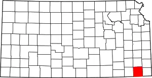 Map of Kansas highlighting Labette County | |
| Unincorporated communities |
| |
| Townships |
| |