Liberal, Kansas
Liberal is a city in southwest Kansas, close to the Oklahoma state border. In 2020, 19,825 people lived there.[3] The city was founded in 1888 and incorporated in the same year.
Liberal, Kansas | |
|---|---|
City and county seat | |
 Welcome sign on U.S. Route 83 | |
|
Logo | |
| Motto: "Crossroads of Commerce" | |
 Location within Seward County and Kansas | |
 KDOT map of Seward County (legend) | |
| Coordinates: 37°02′48″N 100°55′40″W[1] | |
| Country | United States |
| State | Kansas |
| County | Seward |
| Founded | 1888 |
| Incorporated | 1888 |
| Area | |
| • Total | 11.65 sq mi (30.18 km2) |
| • Land | 11.43 sq mi (29.60 km2) |
| • Water | 0.22 sq mi (0.57 km2) |
| Elevation | 2,848 ft (868 m) |
| Population | |
| • Total | 19,825 |
| • Density | 1,700/sq mi (660/km2) |
| Time zone | UTC-6 (CST) |
| • Summer (DST) | UTC-5 (CDT) |
| ZIP codes | 67901, 67905 |
| Area code | 620 |
| FIPS code | 20-39825 |
| GNIS ID | 485613[1] |
| Website | cityofliberal.org |
Sources
- U.S. Geological Survey Geographic Names Information System: Liberal, Kansas
- "2019 U.S. Gazetteer Files". United States Census Bureau. Retrieved July 24, 2020.
- "QuickFacts: Liberal city, Kansas". United States Census Bureau. Retrieved November 17, 2023.
Municipalities and communities of Seward County, Kansas, United States | ||
|---|---|---|
| Cities | 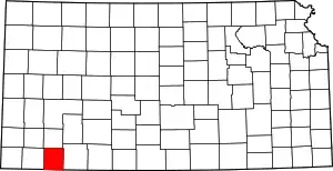 Map of Kansas highlighting Seward County | |
| Unincorporated community |
| |
| Ghost towns |
| |
This article is issued from Wikipedia. The text is licensed under Creative Commons - Attribution - Sharealike. Additional terms may apply for the media files.