Chase County, Kansas
Chase County (county code CS) is a county in the U.S. state of Kansas. In 2020, 2,572 people lived there.[1] Its county seat is Cottonwood Falls. Cottonwood Falls is also the biggest city in Chase County.[2] The center of population of Kansas is in Chase County, about four miles north of Strong City.
Chase County | |
|---|---|
Courthouse.JPG.webp) Chase County Courthouse in Cottonwood Falls | |
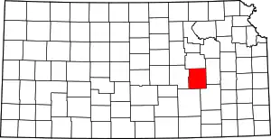 Location within the U.S. state of Kansas | |
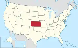 Kansas's location within the U.S. | |
| Coordinates: 38°18′N 96°35′W | |
| Country | |
| State | |
| Founded | February 11, 1859 |
| Named for | Salmon P. Chase |
| Seat | Cottonwood Falls |
| Largest city | Cottonwood Falls |
| Area | |
| • Total | 778 sq mi (2,020 km2) |
| • Land | 773 sq mi (2,000 km2) |
| • Water | 4.7 sq mi (12 km2) 0.6% |
| Population | |
| • Total | 2,572 |
| • Density | 3.3/sq mi (1.3/km2) |
| Time zone | UTC−6 (Central) |
| • Summer (DST) | UTC−5 (CDT) |
| Area code | 620 |
| Congressional district | 2nd |
| Website | chasecountyks.com |
History
In 1859, Chase County was created in the Kansas Territory.
In 1871, the Atchison, Topeka and Santa Fe Railway built a railroad from Emporia to Newton.[3] In 1887, Atchison, Topeka and Santa Fe Railway built a railroad from Neva (3 miles west of Strong City) to Superior, Nebraska. This railroad connected Strong City, Neva, Rockland, Diamond Springs, Burdick, Lost Springs, Jacobs, Hope, Navarre, Enterprise, Abilene, Talmage, Manchester, Longford, Oak Hill, Miltonvale, Aurora, Huscher, Concordia, Kackley, Courtland, Webber, Superior.
The south-western border one mile "notch" into Marion County was created under strange circumstances. There was a murder. Marion County didn't want to have the trial, so a section one mile wide and eighteen miles long was given to Chase County. This was to make it so that the murder had happened there.[4] The one mile strip of land is still part of Chase County.
Geography
The U.S. Census Bureau says that the county has a total area of 778 square miles (2,020 km2). Of that, 773 square miles (2,000 km2) is land and 4.7 square miles (12 km2) (0.6%) is water.[9]
Major highways
Sources: National Atlas,[10] U.S. Census Bureau[11]
- Interstate 35 All of I-35 in Chase County is part of the Kansas Turnpike. The general public can't get to it from inside the county.[12]
- U.S. Route 50
- K-150
- K-177
People
| Historical population | |||
|---|---|---|---|
| Census | Pop. | %± | |
| 1860 | 1,046 | — | |
| 1870 | 1,975 | 88.8% | |
| 1880 | 6,081 | 207.9% | |
| 1890 | 8,233 | 35.4% | |
| 1900 | 8,246 | 0.2% | |
| 1910 | 7,527 | −8.7% | |
| 1920 | 7,144 | −5.1% | |
| 1930 | 6,952 | −2.7% | |
| 1940 | 6,345 | −8.7% | |
| 1950 | 4,831 | −23.9% | |
| 1960 | 3,921 | −18.8% | |
| 1970 | 3,408 | −13.1% | |
| 1980 | 3,309 | −2.9% | |
| 1990 | 3,021 | −8.7% | |
| 2000 | 3,030 | 0.3% | |
| 2010 | 2,790 | −7.9% | |
| 2020 | 2,572 | −7.8% | |
| U.S. Decennial Census[13] 1790-1960[14] 1900-1990[15] 1990-2000[16] 2010-2020[1] | |||
Government
Presidential elections
| Year | Republican | Democratic | Third Parties |
|---|---|---|---|
| 2020 | 75.3% 1,123 | 23.1% 345 | 1.5% 23 |
| 2016 | 70.8% 969 | 23.1% 316 | 6.1% 84 |
| 2012 | 68.8% 875 | 28.2% 358 | 3.0% 38 |
| 2008 | 70.5% 976 | 27.7% 383 | 1.8% 25 |
| 2004 | 70.3% 1,055 | 27.9% 418 | 1.9% 28 |
| 2000 | 64.4% 848 | 29.7% 391 | 5.9% 78 |
| 1996 | 50.2% 778 | 32.0% 496 | 17.8% 276 |
| 1992 | 36.2% 610 | 27.9% 470 | 35.9% 605 |
| 1988 | 60.6% 884 | 36.9% 538 | 2.5% 36 |
| 1984 | 74.0% 1,162 | 25.0% 393 | 1.0% 15 |
| 1980 | 66.9% 1,073 | 25.8% 413 | 7.3% 117 |
| 1976 | 57.6% 922 | 40.2% 643 | 2.3% 36 |
| 1972 | 76.0% 1,184 | 20.2% 315 | 3.7% 58 |
| 1968 | 62.6% 1,038 | 27.9% 462 | 9.5% 158 |
| 1964 | 50.3% 902 | 49.4% 886 | 0.3% 5 |
| 1960 | 64.1% 1,276 | 35.5% 708 | 0.4% 8 |
| 1956 | 74.5% 1,553 | 25.4% 529 | 0.2% 4 |
| 1952 | 77.8% 1,815 | 22.0% 513 | 0.3% 6 |
| 1948 | 58.9% 1,432 | 39.6% 961 | 1.5% 37 |
| 1944 | 60.0% 1,510 | 39.7% 998 | 0.4% 9 |
| 1940 | 57.8% 1,871 | 41.5% 1,344 | 0.7% 23 |
| 1936 | 48.4% 1,610 | 51.3% 1,706 | 0.3% 9 |
| 1932 | 46.0% 1,485 | 52.7% 1,703 | 1.3% 43 |
| 1928 | 72.8% 2,079 | 25.9% 739 | 1.3% 38 |
| 1924 | 62.6% 1,822 | 26.1% 758 | 11.3% 330 |
| 1920 | 63.2% 1,659 | 34.4% 904 | 2.4% 64 |
| 1916 | 44.1% 1,356 | 51.6% 1,584 | 4.3% 132 |
| 1912 | 25.4% 476 | 43.4% 812 | 31.2% 585 |
| 1908 | 53.0% 1,021 | 43.3% 834 | 3.6% 70 |
| 1904 | 64.4% 1,217 | 29.7% 562 | 5.9% 111 |
| 1900 | 52.5% 1,084 | 46.3% 956 | 1.2% 25 |
| 1896 | 44.7% 812 | 54.1% 981 | 1.2% 22 |
| 1892 | 47.4% 891 | 52.7% 990 | |
| 1888 | 54.1% 1,126 | 28.5% 593 | 17.4% 362 |
Education
Unified school districts
- USD 284, Chase County
- Cottonwood Falls, Strong City, Matfield Green, Cedar Point, Elmdale, Clements, Saffordville, Bazaar, Rural Areas
- Chase County Junior/Senior High School
- District Office In Neighboring County
- USD 398, Peabody-Burns
- Wonsevu, Rural Areas
- Peabody-Burns Junior/Senior High School
Communities

References
- "QuickFacts: Chase County, Kansas". United States Census Bureau. Retrieved September 27, 2023.
- "Find a County". National Association of Counties. Archived from the original on 2011-05-31. Retrieved 2011-06-07.
- Santa Fe Rail History
- Kansas State Historical Society - Marion County
- A Landmark of Distinction - The Chase County Courthouse; Historical Marker; Blue Skyways (archived).
- Chase County & The Bluestem Pasture Region of Kansas; Historical Marker; Blue Skyways (archived).
- The Bluestem Pasture Region of Kansas; Historical Marker; Blue Skyways (archived).
- W. B. Strong Memorial Railroad Park; Historical Marker; Blue Skyways (archived).
- "US Gazetteer files: 2010, 2000, and 1990". United States Census Bureau. 2011-02-12. Retrieved 2011-04-23.
- National Atlas Archived December 5, 2008, at the Wayback Machine
- "U.S. Census Bureau TIGER shape files". Archived from the original on 2017-05-23. Retrieved 2017-12-05.
- Google Maps Street View
- "U.S. Decennial Census". United States Census Bureau. Archived from the original on April 26, 2015. Retrieved July 22, 2014.
- "Historical Census Browser". University of Virginia Library. Archived from the original on August 11, 2012. Retrieved July 22, 2014.
- "Population of Counties by Decennial Census: 1900 to 1990". United States Census Bureau. Retrieved July 22, 2014.
- "Census 2000 PHC-T-4. Ranking Tables for Counties: 1990 and 2000" (PDF). United States Census Bureau. Retrieved July 22, 2014.
- "Dave Leip's Atlas of U.S. Presidential Elections".
More reading
- William Least Heat-Moon (1999). PrairyErth (A Deep Map). Mariner Books; Reissue edition (February 15, 1999). ISBN 9780395925690.
- Chase County - Its Past, Present, and Future; Chase County Leader; May 28, 1914.
- Plat Book of Chase County, Kansas; North West Publishing Co; 39 pages; 1901.
Other websites
- Chase County - Official
- Chase County Maps: Current, Historic, KDOT