Dickinson County, Kansas
Dickinson County (county code DK) is a county in Central Kansas. In 2020, 18,402 people lived there.[1] Its county seat is Abilene. Abilene is also the biggest city in Dickinson County.[2] The county was named after Daniel S. Dickinson.[3]
Dickinson County | |
|---|---|
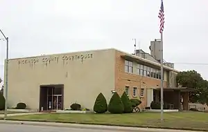 Dickinson County Courthouse in Abilene (2009) | |
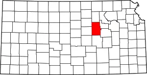 Location within the U.S. state of Kansas | |
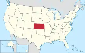 Kansas's location within the U.S. | |
| Coordinates: 38°53′N 97°10′W | |
| Country | |
| State | |
| Founded | February 20, 1857 |
| Named for | Daniel S. Dickinson |
| Seat | Abilene |
| Largest city | Abilene |
| Area | |
| • Total | 852 sq mi (2,210 km2) |
| • Land | 847 sq mi (2,190 km2) |
| • Water | 4.9 sq mi (13 km2) 0.6% |
| Population | |
| • Total | 18,402 |
| • Density | 21.7/sq mi (8.4/km2) |
| Time zone | UTC−6 (Central) |
| • Summer (DST) | UTC−5 (CDT) |
| Area code | 785 |
| Congressional district | 1st |
| Website | DkCoKS.org |
History
19th century

In 1857, Dickinson County was created.
The first railroad in Dickinson County was built through it in 1866.[4]
In 1887, the Chicago, Kansas and Nebraska Railway built a railroad from Topeka to Herington.[5] This main line connected Topeka, Valencia, Willard, Maple Hill, Vera, Paxico, McFarland, Alma, Volland, Alta Vista, Dwight, White City, Latimer, Herington.
21st century
In 2010, the Keystone-Cushing Pipeline (Phase II) was built through Dickinson County. There was a lot of controversy about tax exemption and environmental concerns.[6][7]
Geography
The U.S. Census Bureau says that the county has an area of 852 square miles (2,210 km2). Of that, 847 square miles (2,190 km2) is land and 4.9 square miles (13 km2) (0.6%) is water.[8]
People
| Historical population | |||
|---|---|---|---|
| Census | Pop. | %± | |
| 1860 | 378 | — | |
| 1870 | 3,043 | 705.0% | |
| 1880 | 15,251 | 401.2% | |
| 1890 | 22,273 | 46.0% | |
| 1900 | 21,816 | −2.1% | |
| 1910 | 24,361 | 11.7% | |
| 1920 | 25,777 | 5.8% | |
| 1930 | 25,870 | 0.4% | |
| 1940 | 22,929 | −11.4% | |
| 1950 | 21,190 | −7.6% | |
| 1960 | 21,572 | 1.8% | |
| 1970 | 19,993 | −7.3% | |
| 1980 | 20,175 | 0.9% | |
| 1990 | 18,958 | −6.0% | |
| 2000 | 19,344 | 2.0% | |
| 2010 | 19,754 | 2.1% | |
| 2020 | 18,402 | −6.8% | |
| U.S. Decennial Census[9] 1790-1960[10] 1900-1990[11] 1990-2000[12] 2010-2020[1] | |||
Government
Presidential elections
| Year | Republican | Democratic | Third Parties |
|---|---|---|---|
| 2020 | 76.2% 7,126 | 22.0% 2,060 | 1.7% 163 |
| 2016 | 73.4% 6,029 | 19.6% 1,609 | 7.0% 572 |
| 2012 | 72.5% 5,832 | 25.1% 2,020 | 2.4% 190 |
| 2008 | 70.2% 6,081 | 28.0% 2,422 | 1.9% 164 |
| 2004 | 71.6% 6,295 | 26.9% 2,364 | 1.5% 132 |
| 2000 | 64.8% 5,243 | 29.8% 2,413 | 5.4% 436 |
| 1996 | 60.5% 5,174 | 28.4% 2,423 | 11.1% 951 |
| 1992 | 41.8% 3,851 | 27.3% 2,518 | 30.9% 2,852 |
| 1988 | 63.3% 5,121 | 35.5% 2,870 | 1.3% 101 |
| 1984 | 74.0% 6,487 | 24.7% 2,168 | 1.3% 116 |
| 1980 | 67.6% 5,654 | 25.2% 2,108 | 7.1% 597 |
| 1976 | 55.2% 4,759 | 42.6% 3,672 | 2.2% 186 |
| 1972 | 75.3% 6,515 | 22.6% 1,957 | 2.0% 175 |
| 1968 | 64.3% 5,574 | 27.7% 2,399 | 8.0% 693 |
| 1964 | 53.2% 4,704 | 46.0% 4,070 | 0.8% 73 |
| 1960 | 69.2% 6,956 | 30.4% 3,054 | 0.5% 45 |
| 1956 | 74.9% 7,422 | 24.8% 2,452 | 0.3% 34 |
| 1952 | 81.8% 8,969 | 17.9% 1,967 | 0.3% 31 |
| 1948 | 60.0% 5,918 | 38.7% 3,815 | 1.4% 134 |
| 1944 | 65.9% 6,227 | 33.8% 3,190 | 0.3% 29 |
| 1940 | 63.3% 6,931 | 36.1% 3,957 | 0.6% 70 |
| 1936 | 52.6% 5,936 | 47.1% 5,313 | 0.3% 34 |
| 1932 | 49.0% 5,320 | 49.2% 5,339 | 1.8% 190 |
| 1928 | 77.0% 7,758 | 22.3% 2,246 | 0.7% 66 |
| 1924 | 64.6% 6,178 | 17.7% 1,690 | 17.8% 1,698 |
| 1920 | 69.1% 5,761 | 28.6% 2,387 | 2.3% 189 |
| 1916 | 45.1% 4,323 | 51.9% 4,974 | 3.1% 296 |
| 1912 | 18.3% 988 | 40.4% 2,182 | 41.2% 2,225[lower-alpha 1] |
| 1908 | 53.3% 2,886 | 42.2% 2,282 | 4.6% 246 |
| 1904 | 66.9% 3,185 | 25.6% 1,219 | 7.5% 358 |
| 1900 | 52.9% 2,771 | 44.9% 2,352 | 2.1% 112 |
| 1896 | 48.3% 2,291 | 50.6% 2,399 | 1.1% 52 |
| 1892 | 47.1% 2,419 | 52.9% 2,712 | |
| 1888 | 54.2% 2,746 | 33.4% 1,695 | 12.4% 630 |
Education
Unified school districts
- USD 393, Solomon
- Solomon, Rural Areas
- USD 435, Abilene
- Abilene, Rural Areas
- USD 473, Chapman
- Chapman, Carlton, Manchester, Enterprise, Rural Areas
- USD 487, Herington
- Herington, Rural Areas
- District Office In Neighboring County
- USD 481, Rural Vista (headquarters in White City)
- Hope, Woodbine, Rural Areas
Communities
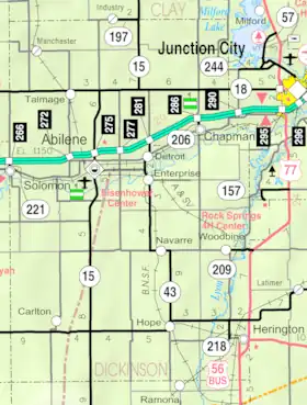
Cities
- Abilene
- Carlton
- Chapman
- Enterprise
- Herington
- Hope
- Manchester
- Solomon (partly in Saline County)
- Woodbine
Famous people
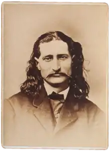
Dwight David "Ike" Eisenhower was the 34th President of the United States from 1953 until 1961. He moved to Abilene when he was 2 years old. Prior to that he was a five-star general in the United States Army. He was Supreme Commander of the Allied Forces in Europe World War II. He planned the invasion of North Africa in Operation Torch in 1942–43 and the invasion of France and Germany in 1944–45.[14] The Eisenhower Library is in Abilene.
Joe Engle is a retired U.S. Air Force colonel and a former NASA astronaut.
References
- "QuickFacts: Dickinson County, Kansas". United States Census Bureau. Retrieved September 27, 2023.
- "Find a County". National Association of Counties. Archived from the original on May 31, 2011. Retrieved June 7, 2011.
- Gannett, Henry (1905). The Origin of Certain Place Names in the United States. Govt. Print. Off. p. 106.
- Blackmar, Frank Wilson (1912). Kansas: A Cyclopedia of State History, Embracing Events, Institutions, Industries, Counties, Cities, Towns, Prominent Persons, Etc. Standard Publishing Company. p. 519. ISBN 9780722249055.
- "Rock Island Rail History". Archived from the original on June 19, 2011. Retrieved July 19, 2019.
- Keystone Pipeline - Marion County Commission calls out Legislative Leadership on Pipeline Deal; April 18, 2010. Archived October 22, 2011, at the Wayback Machine
- Keystone Pipeline - TransCanada inspecting pipeline; December 10, 2010.
- "US Gazetteer files: 2010, 2000, and 1990". United States Census Bureau. February 12, 2011. Retrieved April 23, 2011.
- "U.S. Decennial Census". United States Census Bureau. Archived from the original on April 26, 2015. Retrieved July 24, 2014.
- "Historical Census Browser". University of Virginia Library. Archived from the original on August 11, 2012. Retrieved July 24, 2014.
- "Population of Counties by Decennial Census: 1900 to 1990". United States Census Bureau. Retrieved July 24, 2014.
- "Census 2000 PHC-T-4. Ranking Tables for Counties: 1990 and 2000" (PDF). United States Census Bureau. Retrieved July 24, 2014.
- "Dave Leip's Atlas of U.S. Presidential Elections".
- "Former SACEURs". Aco.nato.int. Archived from the original on July 28, 2012. Retrieved January 26, 2012.
- Notes
- Includes 1,937 votes (35.9%) for Progressive Theodore Roosevelt and 288 votes (5.3%) for Socialist Eugene V. Debs.
More reading
- County
- The Scully Land System in Marion County, Kansas; Homer Socolofsky; Kansas State University; 110 pages; 1944/1947. (includes Dickinson County)
- Standard Atlas of Dickinson County, Kansas; Geo. A. Ogle & Co; 82 pages; 1921.
- Plat Book and Complete Survey of Dickinson County, Kansas; Kenyon Company ; 54 pages; 1909.
- Standard Atlas of Dickinson County, Kansas; Geo. A. Ogle & Co; 63 pages; 1901.
- Portrait and Biographical Record of Dickinson, Saline, McPherson, and Marion Counties, Kansas; Chapman Bros; 614 pages; 1893.
- Trails
- The National Old Trails Road To Southern California, Part 1 (LA to KC); Automobile Club Of Southern California; 64 pages; 1916. (Download 6.8MB PDF eBook)
Other websites
- County
- Dickinson County - Official
- "Dickinson County - Directory of Public Officials". Archived from the original on May 5, 2011.
- Historical
- Maps

