Oneida, Kansas
Oneida is a city in Nemaha County, Kansas, United States. As of the 2020 census, 61 people lived there.[3]
Oneida, Kansas | |
|---|---|
 Location within Nemaha County and Kansas | |
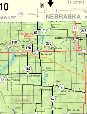 KDOT map of Nemaha County (legend) | |
| Coordinates: 39°52′00″N 95°56′23″W[1] | |
| Country | United States |
| State | Kansas |
| County | Nemaha |
| Platted | 1873 |
| Incorporated | 1884 |
| Named for | Oneida people |
| Area | |
| • Total | 0.23 sq mi (0.60 km2) |
| • Land | 0.23 sq mi (0.60 km2) |
| • Water | 0.00 sq mi (0.00 km2) |
| Elevation | 1,273 ft (388 m) |
| Population | |
| • Total | 61 |
| • Density | 270/sq mi (100/km2) |
| Time zone | UTC-6 (CST) |
| • Summer (DST) | UTC-5 (CDT) |
| ZIP code | 66522 |
| Area code | 785 |
| FIPS code | 20-52900 |
| GNIS ID | 2396068[1] |
History
Oneida was planned out about 1873.[4] It was named after the Oneida people.[5] The town's streets were named after the main thoroughfares of Chicago.[4]
Geography
Oneida is at 39°52′00″N 95°56′23″W (39.866799, -95.93982).
According to the United States Census Bureau says that the city has a total area of 0.23 square miles (0.60 km2). All of it is land.[2]
People
| Historical population | |||
|---|---|---|---|
| Census | Pop. | %± | |
| 1880 | 163 | — | |
| 1890 | 311 | 90.8% | |
| 1900 | 279 | −10.3% | |
| 1910 | 211 | −24.4% | |
| 1920 | 276 | 30.8% | |
| 1930 | 224 | −18.8% | |
| 1940 | 187 | −16.5% | |
| 1950 | 138 | −26.2% | |
| 1960 | 119 | −13.8% | |
| 1970 | 112 | −5.9% | |
| 1980 | 120 | 7.1% | |
| 1990 | 79 | −34.2% | |
| 2000 | 70 | −11.4% | |
| 2010 | 75 | 7.1% | |
| 2020 | 61 | −18.7% | |
| U.S. Decennial Census | |||
References
- U.S. Geological Survey Geographic Names Information System: Oneida, Kansas
- "2020 U.S. Gazetteer Files". United States Census Bureau. Retrieved November 30, 2023.
- "DP1: PROFILE OF GENERAL POPULATION AND HOUSING CHARACTERISTICS". United States Census Bureau. Retrieved November 30, 2023.
- Blackmar, Frank Wilson (1912). Kansas: A Cyclopedia of State History, Volume 2. Standard Publishing Company. p. 392.
- Capace, Nancy (1 June 2000). Encyclopedia of Kansas. North American Book Dist LLC. p. 246. ISBN 978-0-403-09312-0.
- "American FactFinder". United States Census Bureau. Retrieved 2012-07-06.
Other websites
- City
- Schools
- USD 115, local school district
- Maps
- Oneida City Map, KDOT
Municipalities and communities of Nemaha County, Kansas, United States | ||
|---|---|---|
| Cities | 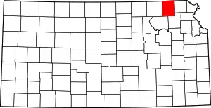 Map of Kansas highlighting Nemaha County | |
| CDP |
| |
| Unincorporated communities |
| |
| Footnotes | ‡This populated place also has portions in an adjacent county or counties | |
This article is issued from Wikipedia. The text is licensed under Creative Commons - Attribution - Sharealike. Additional terms may apply for the media files.