Auburn, Kansas
Auburn is a city in Shawnee County, Kansas, United States. In 2020, 1,273 people lived there.[3]
Auburn, Kansas | |
|---|---|
 Downtown Auburn (2008) | |
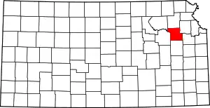
 Location within Shawnee County and Kansas | |
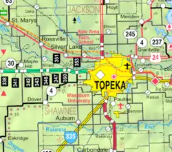 KDOT map of Shawnee County (legend) | |
| Coordinates: 38°54′28″N 95°48′56″W[1] | |
| Country | United States |
| State | Kansas |
| County | Shawnee |
| Founded | 1856 |
| Incorporated | 1963 |
| Area | |
| • Total | 0.70 sq mi (1.81 km2) |
| • Land | 0.70 sq mi (1.80 km2) |
| • Water | 0.00 sq mi (0.01 km2) |
| Elevation | 1,079 ft (329 m) |
| Population | |
| • Total | 1,273 |
| • Density | 1,800/sq mi (700/km2) |
| Time zone | UTC-6 (CST) |
| • Summer (DST) | UTC-5 (CDT) |
| ZIP code | 66402 |
| Area code | 785 |
| FIPS code | 20-03250 [1] |
| GNIS ID | 2394025[1] |
| Website | auburnks.com |
Geography
Auburn is at 38°54′28″N 95°48′56″W (38.907756, -95.815555). The United States Census Bureau says that the city has a total area of 0.70 square miles (1.81 km2). Almost all of it is land.[2]
Weather
Auburn has hot, humid summers and generally mild to cool winters. The Köppen Climate Classification system says that Auburn has a humid subtropical climate, abbreviated "Cfa" on climate maps.[4]
People
| Historical population | |||
|---|---|---|---|
| Census | Pop. | %± | |
| 1880 | 100 | — | |
| 1970 | 261 | — | |
| 1980 | 890 | 241.0% | |
| 1990 | 908 | 2.0% | |
| 2000 | 1,121 | 23.5% | |
| 2010 | 1,227 | 9.5% | |
| 2020 | 1,273 | 3.7% | |
| U.S. Decennial Census | |||
Auburn is part of the Topeka, Kansas Metropolitan Statistical Area.
2020 census
The 2020 census says that there were 1,273 people, 483 households, and 331 families living in Auburn. Of the households, 65.8% owned their home and 34.2% rented their home.
The median age was 34.5 years. Of the people, 89.0% were White, 1.5% were Black, 0.5% were Native American, 0.3% were Asian, 1.1% were from some other race, and 7.5% were two or more races. Hispanic or Latino of any race were 4.8% of the people.[3][5]
Famous people
- Nina E. Allender, artist and women's suffrage activist
References
- U.S. Geological Survey Geographic Names Information System: Auburn, Kansas
- "2019 U.S. Gazetteer Files". United States Census Bureau. Retrieved November 16, 2023.
- "DP1: PROFILE OF GENERAL POPULATION AND HOUSING CHARACTERISTICS". United States Census Bureau. Retrieved November 16, 2023.
- Climate Summary for Auburn, Kansas
- "P16: HOUSEHOLD TYPE". United States Census Bureau. Retrieved December 30, 2023.
- "American FactFinder". United States Census Bureau. Retrieved 2012-07-06.
Other websites
- City
- Schools
- USD 437, local school district
- Maps
- Auburn City Map, KDOT
Municipalities and communities of Shawnee County, Kansas, United States | ||
|---|---|---|
| Cities |
|  Map of Kansas highlighting Shawnee County |
| CDP |
| |
| Unincorporated communities |
| |
| Ghost town |
| |
| Townships |
| |
| Footnotes | ‡This populated place also has portions in an adjacent county or counties | |