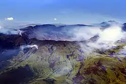
{{free media}}1815 was the "Great Eruption" of Mount Tambora, Indonesia, located at 8°14'43"S, 117°59'34"E.
Great Eruptions

{{fairuse}}On April 10, 1815, Mt. Tambora triggered an explosive eruption. Not only did it explode volcanic ash, but Pumice rocks and volcanic ash have flown shooting out 150 cubic km of pyroclastic material (volcanic ash). Two to three days after the eruption, the atmosphere produced pitch darkness - no light from the sun whatsoever for an area covering 375miles/ 600 km from Tambora. The area that was blanketed in ash is also currently approximately the distance from the drive from Boston to Wichita, Kansas. This was one of the largest known ash-producing eruptions in the last 10,000 years, so they called this event the “Great Eruption”. The Great eruption reduced the volcano to half its former size. Tambora is still a large stratovolcano (2860 m tall and 1000 km3 in volume) located on the Indonesian island of Sumbawa (part of the Lesser Sunda Islands).
Locations
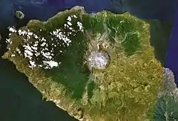
{{free media}}Mount Tambora is centered in the image on the right on the Sumbawa Island, (Southern) Indonesia. Sumbawa Island is east of Bali and Colombo. Sumbawa Island is made up of hundreds of small islands in this area including the two major ones. It is largely mountainous with rocky coasts and a few small plains. Latitude: S. 8° 15’ Longitude: E. 118° 0’.
Aftermaths
The “Great Eruption” caused the years of 1815-1816 known as the “Year(s) without a summer”. The effect of the “Great Eruption” produced a drop in average global temperature between 0.4 - 0.7° Celsius, while warming the atmosphere by as much as 15 Kelvin. Mount Tambora caused a prodigious transaction or turmoil and mayhem:
- Crop failures- famine
- Acid fogs, cold winters, penetrating sunsets
- Haze through the Northern hemisphere: as far as London, Russia, the US, and beyond
- Dreary summers/ extreme weather in the spring and summertime
Global Human Impacts
Of the island of Sumbawa’s 12,000 inhabitants, only 26 survived. In addition continuous, frequent earthquakes, pyroclastic flows and tsunamis associated with the event initiated fatalities with an estimate of about 92,000 deaths. The 92,000 deaths occurred in just a few days. The ash polluted water supply and the atmosphere full of ash and volcanic gases. Rapidly, famines and disease extended across the province and the exact number of deaths will never be known.
In Europe, the summer of 1816 was cool and exceedingly wet. Immense crop failures led to famines, disease, and social turmoil. In central England, the temperature was about 1.5°C cooler than during the summer of 1815. Typhus (a bacterial disease spread by lice or fleas) was reported in almost every town and village in England, and was reported in many cities throughout Scotland. In Ireland, approximately 800,000 people were infected during the typhus epidemic, because of that, 4,300 perished from the mutual devastation of famine, dysentery, and fever. Somewhere else in Europe, the summer of 1816 was also recorded to be one of the most miserable winters in contemporary history.
In the US, 1816 was marked by a persistent dry fog, or dim sun, as reported in the northeastern United States. According to a report from New York, the atmospheric pollution reddened and dimmed the sun so much that sunspots were visible to the naked eye. Unusually, the total lunar eclipse on June 9th-10th was also testified to be extremely darker than normal. The summer of 1816 was the coldest in New Haven, Connecticut, with frosts! The next day, a cold front gripped most of New England. Severe frosts had spread city to city and state to state. Conditions continued over the next 3 months, which reduced the growing season and resulted in almost total failure of main crops.
Canada also experienced severe weather and the same cold wave that hit New England. There was snow falling in the beginning of June. Unlike the British Isles and North America, Canada did not go through serious distresses (due to their full resources).
Sources
{{free media}}
{{free media}}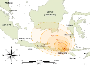
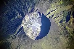
{{free media}}The image at right is a "detailed astronaut photograph [that] depicts the summit caldera of the volcano. The huge caldera—6 kilometers (3.7 miles) in diameter and 1,100 meters (3,609 feet) deep—formed when Tambora’s estimated 4,000-meter- (13,123-foot) high peak was removed, and the magma chamber below emptied during the April 10 eruption. Today the crater floor is occupied by an ephemeral freshwater lake, recent sedimentary deposits, and minor lava flows and domes from the nineteenth and twentieth centuries. Layered tephra deposits are visible along the northwestern crater rim. Active fumaroles, or steam vents, still exist in the caldera."[1]
"On April 10, 1815, the Tambora Volcano produced the largest eruption in recorded history. An estimated 150 cubic kilometers (36 cubic miles) of tephra—exploded rock and ash—resulted, with ash from the eruption recognized at least 1,300 kilometers (808 miles) away to the northwest. While the April 10 eruption was catastrophic, historical records and geological analysis of eruption deposits indicate that the volcano had been active between 1812 and 1815. Enough ash was put into the atmosphere from the April 10 eruption to reduce incident sunlight on the Earth’s surface, causing global cooling, which resulted in the 1816 “year without a summer.”"[1]
Map of April 5-11, 1815, second image down on the righy, shows the results of the Mount Tambora eruption, on the island of Sumbawa in Indonesia, with explosion path and fallout around the caldera. The red ring-areas are graduated bands of the thickness of volcanic ashfall. The explosion had 4 times the energy of the later Krakatoa eruption, in 1883.
Volcanicity

{{free media}}Def. the "level of power of a volcano"[2] is called its volcanicity.
'Mount Tambora' (or Tamboro) is an active stratovolcano, or composite volcano, on the island of Sumbawa, Indonesia. After a large magma chamber inside the mountain filled over the course of several decades, volcanic activity reached a historic climax in the super-colossal eruption of April 1815 (185 b2k).[3]
This eruption is rated 7 on the Volcanic Explosivity Index (VEI), the only such eruption since the Lake Taupo Hatepe eruption in about 180 AD.[4] With an estimated ejecta volume of 160 km3, Tambora's 1815 outburst is the largest volcanic eruption in recorded history. The giant eruption acidified the atmosphere for more than two years. This tephra layer, or acidity signal, in Greenland is relatively weak, because the eruptions happened south of the equator, but has been found in Dye 3 and other Greenland ice cores.[5]
Volcanism
{{free media}}
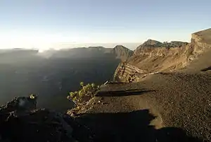
{{free media}}The image on the right exhibits strata in the crater rim of Mount Tambora as evidence of previous eruptions.
The image on the left exhibits sulfate concentration in an ice core from Central Greenland, dated by counting oxygen isotope seasonal variations. There is an unknown eruption around the 1810s.[6]
The 1815 eruption released 10 to 120 megatonnes of sulfur[4] into the stratosphere, causing a global climate anomaly. Different methods have been used to estimate the ejected sulfur mass: the petrological method, an optical depth measurement based on anatomical observations, and the polar ice core sulfate concentration method, which calibrated against cores from Greenland and Antarctica.[4]
In the spring and summer of 1816, a persistent stratospheric sulfate aerosol veil, described then as a "dry fog", was observed in the northeastern United States that was not dispersed by wind or rainfall, and it reddened and dimmed sunlight to an extent that sunspots were visible to the naked eye.[4] Areas of the northern hemisphere suffered extreme weather conditions and 1816 became known as the "year without a summer". Average global temperatures decreased about 0.4 to 0.7 °C (0.7 to 1.3 °F),[7] enough to cause significant agricultural problems around the globe. After 4 June 1816, when there were frosts in Connecticut, cold weather expanded over most of New England: on 6 June 1816, it snowed in Albany, New York, and Dennysville, Maine; similar conditions persisted for at least three months, ruining most crops across North America while Canada experienced extreme cold and snow fell until 10 June near Quebec City, accumulating to 30 centimetres (12 in).[4]
That year became the second-coldest year in the northern hemisphere since 1400,[8] while the 1810s were the coldest decade on record, a result of Tambora's eruption and other suspected volcanic events between 1809 and 1810.[9] (See sulfate concentration chart.) Surface-temperature anomalies during the summers of 1816, 1817 and 1818 were −0.51, −0.44 and −0.29 °C, respectively.[8] Along with a cooler summer, parts of Europe experienced a stormier winter,[4] and the Elbe and Ohře Rivers froze over a period of twelve days in February 1816. As a result, prices of wheat, rye, barley and oats rose dramatically by 1817.[10]
Tephra layers

{{free media}}The heavy tephra-tinged rain did not finally recede until 17 April.[7] Analysis of various sites on Mount Tambora using ground-penetrating radar has revealed alternations of pumice and ash deposits covered by the pyroclastic surge and flow sediments that vary in thickness regionally.[11]
Hypotheses
- The eruptions of Mount Tambora have been decreasing over the millennia.
See also
References
- 1 2 Warren Wiscombe (July 19, 2009). Mount Tambora Volcano, Sumbawa Island, Indonesia. NASA Earth Observatory. Retrieved 2013-03-30.
- ↑ Borganised (23 October 2008). volcanicity. San Francisco, California: Wikimedia Foundation, Inc. Retrieved 2015-03-21.
- ↑ Degens, E.T.; Buch, B (1989). "Sedimentological events in Saleh Bay, off Mount Tambora". Netherlands Journal of Sea Research 24 (4): 399–404. doi:10.1016/0077-7579(89)90117-8.
- 1 2 3 4 5 6 Oppenheimer, Clive (2003). "Climatic, environmental and human consequences of the largest known historic eruption: Tambora volcano (Indonesia) 1815". Progress in Physical Geography 27 (2): 230–259. doi:10.1191/0309133303pp379ra.
- ↑ Dansgaard W. Frozen Annals Greenland Ice Sheet Research. Odder, Denmark: Narayana Press. p. 124. ISBN 87-990078-0-0.
- ↑ Dai, J.; Mosley-Thompson, E.; Thompson, L.G. (1991). "Ice core evidence for an explosive tropical volcanic eruption six years preceding Tambora". Journal of Geophysical Research: Atmospheres 96 (D9): 17361–17366. doi:10.1029/91JD01634. https://pdfs.semanticscholar.org/4574/f163f9c8321c258cf88710e69e0fd0a3de13.pdf. Retrieved 2 August 2018.
- 1 2 Stothers, Richard B. (1984). "The Great Tambora Eruption in 1815 and Its Aftermath". Science 224 (4654): 1191–1198. doi:10.1126/science.224.4654.1191. PMID 17819476.
- 1 2 Briffa, K.R.; Jones, P.D.; Schweingruber, F.H.; Osborn, T.J. (1998). "Influence of volcanic eruptions on Northern Hemisphere summer temperature over the past 600 years". Nature 393 (6684): 450–455. doi:10.1038/30943.
- ↑ Cole‐Dai, Jihong; Ferris, David; Lanciki, Alyson; Savarino, Joël; Baroni, Mélanie; Thiemens, Mark H. (1 November 2009). "Cold decade (AD 1810–1819) caused by Tambora (1815) and another (1809) stratospheric volcanic eruption". Geophysical Research Letters 36 (22). doi:10.1029/2009GL040882.
- ↑ Brázdil, Rudolf; Řezníčková, Ladislava; Valášek, Hubert; Dolák, Lukáš; Kotyza, Oldřich (2016). "Climatic effects and impacts of the 1815 eruption of Mount Tambora in the Czech Lands". Climate of the Past 12: 1361–1374. https://www.clim-past.net/12/1361/2016/cp-12-1361-2016.pdf. Retrieved 2 August 2018.
- ↑ Abrams, Lewis J.; Sigurdsson, Haraldur (2007). "Characterization of pyroclastic fall and flow deposits from the 1815 eruption of Tambora volcano, Indonesia using ground-penetrating radar". Journal of Volcanology and Geothermal Research 161: 352–361. doi:10.1016/j.jvolgeores.2006.11.008. http://people.uncw.edu/abramsl/Abrams-Sigurdsson-volgeo-07.pdf. Retrieved 2 August 2018.
External links
- http://www.universetoday.com/31840/mount-tambora/
- http://www.hawaii247.com/2011/09/29/volcano-watch-infamous-mount-tambora-is-rumbling-again/
- http://www.earthobservatory.nasa.gov/IOTD/view.php?id=39412
- http://www.geolsoc.org.uk/page2972.html
- http://scienceblogs.com/eruptions/2009/04/194_years_since_the_great_tamb.php
- http://hilo.hawaii.edu/academics/hohonu/writing.php?id=137
- http://ngm.nationalgeographic.com/2008/01/volcano-culture/mount-tambora-photography
- http://www.wired.com/science/discoveries/news/2009/04/dayintech_0410