Niort
Niort is a commune in the Deux-Sèvres department in the Nouvelle-Aquitaine region in western France. It is a prefecture of the Deux-Sèvres department. It is also the capital of the arrondissement of Niort.
Niort | |
|---|---|
Prefecture and commune | |
 The old centre of Niort | |
.svg.png.webp) Coat of arms | |
Location of Niort | |
 Niort  Niort | |
| Coordinates: 46°50′27″N 0°29′14″W | |
| Country | France |
| Region | Nouvelle-Aquitaine |
| Department | Deux-Sèvres |
| Arrondissement | Niort |
| Canton | Niort-1 Niort-2 Niort-3 |
| Intercommunality | Le Niortais |
| Government | |
| • Mayor (2014–2020) | Jérome Baloge[1] |
| Area 1 | 68.20 km2 (26.33 sq mi) |
| Population (2014) | 58,311 |
| • Density | 860/km2 (2,200/sq mi) |
| Demonym | Niortais |
| Time zone | UTC+01:00 (CET) |
| • Summer (DST) | UTC+02:00 (CEST) |
| INSEE/Postal code | 79191 /79000 |
| Elevation | 2–77 m (6.6–252.6 ft) (avg. 40 m or 130 ft) |
| Website | www.vivre-a-niort.com |
| 1 French Land Register data, which excludes lakes, ponds, glaciers > 1 km2 (0.386 sq mi or 247 acres) and river estuaries. | |
Geography
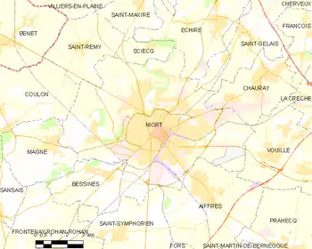
Niort is to the southwest of the Deux-Sèvres department on the left side of the Sèvre Niortaise river. The city is the main place to get into the Marais Poitevin, a large area of marshland in western France.
Niort is at about 41 km (25 mi) from Parthenay and about 64 km (40 mi) from Bressuire, the two subprefectures of the department.
The city is also at about 187 km (116 mi) from Bordeaux, 411 km (255 mi) from Paris, 827 km (514 mi) from Marseille and 423 km (263 mi) from Toulouse.
The commune has an area of 68.2 km2 (26.3 sq mi).[2] Its average altitude is 40 m (130 ft); at the city hall, the altitude is 28 m (92 ft).[3]
 |
The commune of Niort is surrounded by the communes:
Climate
The climate of Niort is an oceanic climate with template summers, Cfb (Marine West Coast Climate) in the Köppen climate classification.[4]
The average amount of precipitation for the year in Niort is 647.7 mm (25.5 in). The month with the most precipitation on average is September with 94 mm (3.7 in) of precipitation. The month with the least precipitation on average is July with an average of 25.4 mm (1.0 in).
The average temperature for the year in Niort is 12.5 °C (54.5 °F). The warmest month, on average, is July with an average temperature of 20.2 °C (68.4 °F). The coolest month on average is January, with an average temperature of 5.5 °C (41.9 °F).
Population
The inhabitants of Niort are known, in French, as Niortais (women: Niortaises).[5]
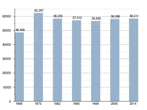
With a population of 58,311,[6] Niort has a population density of 855 inhabitants/km2.
Evolution of the population in Niort

Niort forms, with other 3 communes, the urban area of Niort with a population of 71,127 inhabitants (2013) and an area of 119.8 km2 (46.3 sq mi).[7] This urban area is the centre of the metropolitan area of Niort, formed by 76 communes with a population of 154,160 inhabitants (2013) and an area of 1,373.3 km2 (530.2 sq mi).[8]
Administration
Niort is the prefecture of the Deux-Sèvres department, the capital of the arrondissement of Niort and the administrative centre (French: chef-lieu) of three cantons:
- Niort-1, with 19,481 inhabitants (2014).
- Niort-2, with 18,806 inhabitants (2014).
- Niort-3, with 20,024 inhabitants (2014).
It is part of the intercommunality Le Niortais (French: Communauté d'agglomération du Niortais).
Twinned and partner towns
 Atakpamé, Togo, since 1958
 Coburg, Bavaria, Germany, since 1974
.svg.png.webp) Wellingborough, Northamptonshire, England, United Kingdom, since 1977
Wellingborough, Northamptonshire, England, United Kingdom, since 1977 Springe, Lower Saxony, Germany, since 1979
 Tomelloso, Spain, since 1981
 Gijón, Asturias, Spain, since 1982
 Biała Podlaska, Poland, since 1995
References
- "Les élus" (in French). Vivre à Niort. Retrieved 21 April 2017.
- "Commune de Niort (79191)". Comparateur de territoire (in French). Institut national de la statistique et des études économiques - INSEE. Retrieved 21 April 2017.
- "Niort". Map-France.com. Retrieved 21 April 2017.
- "Niort, France - Köppen Climate Classification". Weatherbase. Retrieved 21 April 2017.
- "Deux-Sèvres (79)" (in French). habitants.fr. Retrieved 21 April 2017.
- "Régions, départements, arrondissements, cantons et communes" (PDF). Populations légales 2014 (in French). Institut national de la statistique et des études économiques - INSEE. Retrieved 21 April 2017.
- "Unité urbaine de Niort (79501)". Comparateur de territoire (in French). Institut national de la statistique et des études économiques - INSEE. Retrieved 21 April 2017.
- "Aire urbaine de Niort (054)". Comparateur de territoire (in French). Institut national de la statistique et des études économiques - INSEE. Retrieved 21 April 2017.
- "Jumelage" (in French). Vivre à Niort. Retrieved 21 April 2017.
Other websites
- City Council website (in French)
- CA du Niortais (in French)

