Creuse
Creuse (Occitan: Cruesa) is a department in central France in the region of Nouvelle-Aquitaine. It is named after the Creuse river that flows through the department.
Creuse | |
|---|---|
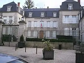 Prefecture building of the Creuse department, in Guéret | |
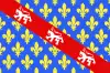 Flag  Coat of arms | |
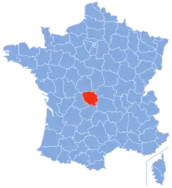 Location of Creuse in France | |
| Coordinates: 46°35′N 2°3′E | |
| Country | France |
| Region | Nouvelle-Aquitaine |
| Département | 4 March 1790 |
| Prefecture | Guéret |
| Subprefecture | Aubusson |
| Government | |
| • President | Valérie Simonet |
| Area | |
| • Total | 5,565.4 km2 (2,148.8 sq mi) |
| Population (2014)[2] | |
| • Total | 120,581 |
| • Density | 22/km2 (56/sq mi) |
| Demonym | Creusois |
| Time zone | UTC+1 (CET) |
| • Summer (DST) | UTC+2 (CEST) |
| ISO 3166 code | FR-23 |
| Arrondissements | 2 |
| Cantons | 15 |
| Communes | 258 |
| Website | www.creuse.fr |
History
Creuse is one of the 83 French departments made during the French revolution, on 4 March 1790. It was created mainly with lands of the old province of County of La Marche.
The new department had seven districts: La Souterraine, Guéret, Boussac, Évaux, Felletin, Bourganeuf and Aubusson. The capital (now prefecture) was Guéret alternating with Aubusson, but soon only Guéret remained as capital.[3]
In 1800, with the creation of the arrondissements in France, the seven districts were changed into four arrondissements: Guéret, Aubusson, Bourganeuf and Boussac.[3]
On 10 September 1926, the arrondissements of Bourganeuf et Boussac were eliminated.[3]
Geography

Creuse is part of the Nouvelle-Aquitaine region. It has an area of 120,872 km2 (46,669 sq mi).[1]
The department is surrounded by 6 departments in 3 regions:
- Nouvelle-Aquitaine region
- Corrèze department
- Haute-Vienne department
- Centre-Val de Loire region
- Auvergne-Rhône-Alpes region
- Allier department
- Puy-de-Dôme department
Places next to Creuse | ||||||||||
|---|---|---|---|---|---|---|---|---|---|---|
| ||||||||||
The department is in the northwestern part of the Massif Central; the Millevaches plateau is in the southeastern part of the department. The highest point is in Forêt de Châteauvert (45°42′38″N 02°20′45″E), "commune" of Saint-Oradoux-de-Chirouze, southeastern of the department and in northeastern Massif Central; it is 932 m (3,058 ft) high;[4] the lowest point is in the valley of the Creuse river, 175 m (574 ft) high.
The main river in the department is the Creuse, a tributary of the Vienne river and that gives its name to this the deparment; it flows through the department from the southeast to the northwest.
Administration
The department is managed by the Departamental Council of the Creuse in Guéret. Creuse is part of the region of Nouvelle-Aquitaine.
Administrative divisions
There are 2 arrondissements (districts), 15 cantons and 258 communes (municipalities) in Haute-Vienne.[5]
| INSEE code | Arrondissement | Capital | Population[6] (2014) | Area[7] (km²) | Density (Inh./km²) | Communes |
|---|---|---|---|---|---|---|
| 231 | Aubusson | Aubusson | 37,123 | 2,538.8 | 14.6 | 118 |
| 232 | Guéret | Guéret | 83,458 | 3,026.5 | 27.6 | 140 |
The following is a list of the 15 cantons of the Creuse department (with their INSEE codes), in France, following the French canton reorganisation which came into effect in March 2015:[8]
- Ahun (2301)
- Aubusson (2302)
- Auzances (2303)
- Bonnat (2304)
- Bourganeuf (2305)
- Boussac (2306)
- Dun-le-Palestel (2307)
- Évaux-les-Bains (2308)
- Felletin (2309)
- Gouzon (2310)
- Le Grand-Bourg (2311)
- Guéret-1 (2312)
- Guéret-2 (2313)
- Saint-Vaury (2314)
- La Souterraine (2315)
Demographics
The inhabitants of Creuse are known, in French, as Creusois (women: Creusoises).[9]
Creuse has a population, in 2014, of 120,581,[2] for a population density of 21.7 inhabitants/km2. The arrondissement of Guéret, with 83,458 inhabitants, is by far the largest. The other arrondissement, Aubusson, has 37,123 inhabitants.[6]
Evolution of the population in Dordogne

The main cities in the department are:
| City | Population[6] (2014) |
Arrondissement |
|---|---|---|
| Guéret | 13,342 | Guéret |
| La Souterraine | 5,295 | Guéret |
| Aubusson | 3,591 | Aubusson |
| Bourganeuf | 2,725 | Guéret |
| Sainte-Feyre | 2,470 | Guéret |
| Saint-Sulpice-le-Guérétois | 1,987 | Guéret |
| Saint-Vaury | 1,791 | Guéret |
| Felletin | 1,700 | Aubusson |
| Gouzon | 1,575 | Guéret |
| Ahun | 1,466 | Guéret |

_-_Vue_vers_Ruffec_-_viaduc.jpg.webp)
Related pages
References
- "Département de la Creuse (23)". Comparateur de territoire (in French). Institut national de la statistique et des études économiques - INSEE. Retrieved 22 May 2017.
- "Populations légales 2014 des départements et des collectivités d'outre-mer" (in French). Institut national de la statistique et des études économiques - INSEE. Retrieved 22 May 2017.
- "Historique de la Creuse". Le SPLAF (in French). Retrieved 5 September 2016.
- "Forêt de Châteauvert, France". Peakbagger.com. Retrieved 5 September 2016.
- "Département de la Creuse (23)" (in French). Institut national de la statistique et des études économiques - INSEE. Retrieved 22 May 2017.
- "Régions, départements, arrondissements, cantons et communes" (PDF). Populations légales 2014 (in French). Institut national de la statistique et des études économiques - INSEE. Retrieved 22 May 2017.
- "Département de la Creuse (23)". Comparateur de territoire (in French). Institut national de la statistique et des études économiques - INSEE. Retrieved 22 May 2017.
- "Décret n° 2014-161 du 17 février 2014 portant délimitation des cantons dans le département de la Creuse" (in French). Legifrance.gouv.fr. Retrieved 14 April 2015.
- "Creuse (23)" (in French). habitants.fr. Retrieved 5 September 2016.
Other websites
- Departamental Council website (in French)
- Prefecture website (in French)
- Tourism office of Creuse (in French)