Auvergne-Rhône-Alpes
Auvergne-Rhône-Alpes (Franco-Provençal: Ôvèrgne-Rôno-Ârpes; Occitan: Auvèrnhe Ròse Aups) is an administrative region of France that was created on 1 January 2016 from the former French regions Auvergne and Rhône-Alpes. It is in the central and eastern parts of southern France.
Auvergne-Rhône-Alpes
| |
|---|---|
.jpg.webp) Lake Annecy in the French Alps | |
 Flag  Coat of arms | |
 | |
| Country | |
| Prefecture | Lyon[1] |
| Departments | 13 (12 normal departments, and 1 metropolis) |
| Government | |
| • President of the Regional Council | Laurent Wauquiez (LR) |
| • Prefect | Pascal Mailhos |
| Area | |
| • Total | 69,711 km2 (26,916 sq mi) |
| • Rank | 4th |
| Population | |
| • Total | 8,042,936 |
| • Density | 120/km2 (300/sq mi) |
| Demonym(s) | Auvergnat / Rhônalpin Aurhalpin (rare & non-official) |
| Time zone | UTC+01:00 (CET) |
| • Summer (DST) | UTC+02:00 (CEST) |
| ISO 3166 code | FR-ARA |
| GDP () | Ranked |
| Total | $327 billion (US$ bn) |
| Per capita | $40,200 (US$) |
| Website | auvergnerhonealpes |
Geography
The Auvergne-Rhône-Alpes region is the third largest region of Metropolitan France, after Nouvelle-Aquitaine and Occitanie, with an area of 69,711.2 km2 (26,916 sq mi). It borders five French administrative regions: Bourgogne-Franche-Comté to the north, Centre-Val de Loire to the northwest, Nouvelle-Aquitaine to the west, Occitanie to the southwest and Provence-Alpes-Côte d'Azur to the southeast. It also borders two countries: Italy to the east and Switzerland to the northeast.
The region has the Massif Central to the east and the Alps to the east, with the valley of the Rhône river between them. Half of the Ain department is occupied by the Jura Mountains.
The extreme points for the region are in the communes:
- North : Château-sur-Allier, Allier (46.804272°N 2.959629°E)
- East : Bonneval-sur-Arc, Savoie (45.403287°N 7.185578°E)
- South : Ferrassières, Drôme (44.115494°N 5.494467°E)
- West : Siran, Cantal (44.976621°N 2.062885°E)
Its capital, Lyon, is at 465 km (289 mi) to the southwest of Paris, the national capital, at 315 km (196 mi) to the northwest of Marseille and at 554 km (344 mi) to the west of Bordeaux.
The distances from the different departmental capitals to Lyon, the regional capital, are:
- Bourg-en-Bresse (Ain) - 81 km (50 mi)
- Moulins (Allier) - 204 km (127 mi)
- Privas (Ardèche) - 142 km (88 mi)
- Aurillac (Cantal) - 314 km (195 mi)
- Valence (Drôme) - 102 km (63 mi)
- Grenoble (Isère) - 106 km (66 mi)
- Saint-Étienne (Loire) - 63 km (39 mi)
- Le Puy-en-Velay (Haute-Loire) - 134 km (83 mi)
- Clermont-Ferrand (Puy-de-Dôme) - 164 km (102 mi)
- Chambéry (Savoie) - 99 km (62 mi)
- Annecy (Haute-Savoie) - 101 km (63 mi)
Rivers
There are two main drainage basin in the region; some rivers in those basins are:
Mountains
The Mont Blanc (42°46′26″N 0°8′51″E), at 4,810 m (15,780 ft), is the highest mountain of the Auvergne-Rhône-Alpes region, France, Italy and of Western Europe.[3]
The highest points in the different departments of the Auvergne-Rhône-Alpes region are:[4]
| Department | Mountain | Elevation |
|---|---|---|
| Ain | Crêt de la Neige | 1,720 m (5,640 ft) |
| Allier | Puy de Montoncel | 1,287 m (4,222 ft) |
| Ardèche | Mont Mézenc | 1,753 m (5,751 ft) |
| Cantal | Plomb du Cantal | 1,855 m (6,086 ft) |
| Drôme | Rocher Rond | 2,453 m (8,048 ft) |
| Isère | Pic Lory | 4,088 m (13,412 ft) |
| Loire | Pierre-sur-Haute | 1,634 m (5,361 ft) |
| Haute-Loire | Mont Mézenc | 1,753 m (5,751 ft) |
| Puy-de-Dôme | Puy de Sancy | 1,885 m (6,184 ft) |
| Rhône | Mont Saint-Rigaud | 1,009 m (3,310 ft) |
| Savoie | La Grande Casse | 3,855 m (12,648 ft) |
| Haute-Savoie | Mont Blanc | 4,810 m (15,780 ft) |
Departments
The Auvergne-Rhône-Alpes region is formed by 13 departments:
| ISO 3166-2 |
Shield | Department | Prefecture | Arr. | Cant. | Comm. | Population (2014)[5] |
Area (km²) |
Density (Inh./km²) |
|---|---|---|---|---|---|---|---|---|---|
| FR-01 | Ain | Bourg-en-Bresse | 4 | 23 | 408 | 626,127 | 5,762.4 | 108.7 | |
| FR-03 | Allier | Moulins | 3 | 19 | 317 | 343,062 | 7,340.1 | 46.7 | |
| FR-07 | Ardèche | Privas | 3 | 17 | 339 | 322,381 | 5,528.6 | 58.3 | |
| FR-15 | Cantal | Aurillac | 3 | 15 | 255 | 146,618 | 5,726.0 | 25.6 | |
| FR-26 | Drôme | Valence | 3 | 19 | 367 | 499,159 | 6,530.0 | 76.4 | |
| FR-38 | Isère | Grenoble | 3 | 29 | 521 | 1,243,597 | 7,431.5 | 167.3 | |
| FR-42 | Loire | Saint-Étienne | 3 | 21 | 326 | 757,305 | 4,780.6 | 158.4 | |
| FR-43 | Haute-Loire | Le Puy-en-Velay | 3 | 19 | 257 | 226,565 | 4,977.1 | 45.5 | |
| FR-63 | Puy-de-Dôme | Clermont-Ferrand | 5 | 31 | 467 | 644,216 | 7,969.7 | 80.8 | |
| FR-69 | Rhône | Lyon | 2 | 13 | 289 | 1,801,885 | 3,249.1 | 554.6 | |
| FR-73 | Savoie | Chambéry | 3 | 19 | 285 | 426,924 | 6,028.3 | 70.8 | |
| FR-74 | Haute-Savoie | Annecy | 4 | 17 | 281 | 783,127 | 4,387.8 | 178.5 | |
| Total of the Region | 39 | 242 | 4,112 | 7,820,966 | 69,711.2 | 112.2 | |||
Arr. = Arrondissements Cant. = Cantons Comm. = Communes
Demographics
The Auvergne-Rhône-Alpes region had a population, in 2014, of 7,820,966,[6] for a population density of 112.2 inhabitants/km2. The department with more people living in it is Rhône with 1,801,885 inhabitants.
The main cities in the region are:
| INSEE code |
City | Department | Population (2014) |
|---|---|---|---|
| 69123 | Lyon | Métropole de Lyon | 506,615 |
| 42218 | Saint-Étienne | Loire | 170,761 |
| 38185 | Grenoble | Isère | 160,779 |
| 69266 | Villeurbanne | Métropole de Lyon | 148,543 |
| 63113 | Clermont-Ferrand | Puy-de-Dôme | 141,365 |
| 74010 | Annecy | Haute-Savoie | 124,376 |
| 69259 | Vénissieux | Métropole de Lyon | 62,575 |
| 26362 | Valence | Drôme | 62,150 |
| 73065 | Chambéry | Savoie | 59,490 |
| 69256 | Vaulx-en-Velin | Métropole de Lyon | 45,294 |
Gallery
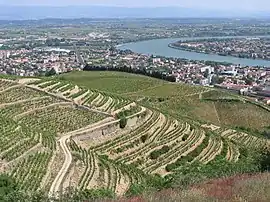 The valley of the Rhône river.
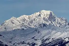 South side of the Mont Blanc.
.jpg.webp) Fourvière Basilica (Lyon) viewed from the Saône river.
Fourvière Basilica (Lyon) viewed from the Saône river.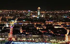 Overview on Lyon during Fête des Lumières.
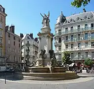 Fountain of the Three Orders, Grenoble
Related pages
References
- "Décret No. 2016-1266 du 28 septembre 2016 portant fixation du nom et du chef-lieu de la région Auvergne-Rhône-Alpes" (in French). 28 September 2016. Retrieved 3 July 2017..
- "Téléchargement du fichier d'ensemble des populations légales en 2019". The National Institute of Statistics and Economic Studies. 28 December 2020.
- "Mont Blanc, France/Italy". Peakbagger.com. Retrieved 19 October 2016.
- "France Department High Points". Peakbagger.com. Retrieved 3 November 2017.
- "Populations légales 2014 des départements et des collectivités d'outre-mer" (in French). Institut national de la statistique et des études économiques - INSEE. Retrieved 6 January 2017.
- "Populations légales 2014: Recensement de la population - Population des régions" (in French). Institut national de la statistique et des études économiques - INSEE. Retrieved 3 November 2017.
Other websites
- Official website of the region (in French)
- Prefecture of the region (in French)