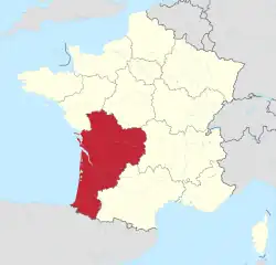
Nouvelle-Aquitaine
Nouvelle-Aquitaine (Occitan: Nòva Aquitània) is one of the administrative regions of France. Its capital is Bordeaux.[2] By land area, it is the largest region of France.
Nouvelle-Aquitaine
| |
|---|---|
 The Château de la Roque in Meyrals | |
 Flag  Coat of arms | |
 | |
| Country | |
| Prefecture | Bordeaux |
| Departments | |
| Government | |
| • President of the Regional Council | Alain Rousset (PS) |
| Area | |
| • Total | 84,036 km2 (32,446 sq mi) |
| • Rank | 1st |
| Population | |
| • Total | 6,010,289 |
| • Density | 72/km2 (190/sq mi) |
| Demonym | New-aquitanians |
| Time zone | UTC+01:00 (CET) |
| • Summer (DST) | UTC+02:00 (CEST) |
| ISO 3166 code | FR-NAQ |
| GDP () | Ranked |
| Total | € billion (US$ bn) |
| Per capita | € (US$) |
| Official languages | French |
It is in the southwest of France formed in 2014 by three old regions: Aquitaine, Limousin and Poitou-Charentes. Aquitaine-Limousin-Poitou-Charentes was the temporary name for the region.
Geography

The Nouvelle-Aquitaine region is the largest region of France with an area of 84,035.7 km2 (32,446 sq mi).[3] It is in southwestern France and borders to the northwest with the Pays de la Loire region, to the north with the Centre-Val de Loire region, to the east with the Auvergne-Rhône-Alpes region, to the southwest with the Occitanie region and to the south with Spain.
The Nouvelle-Aquitaine has about 720 km (450 mi) of coast along the Atlantic Ocean.[4]
The distances from Bordeaux, the capital of the region, to other cities are:
- Paris, the national capital, 585 km (364 mi)
- Toulouse, 243 km (151 mi)
- Marseille, 645 km (401 mi)
- Lyon, 554 km (344 mi)
- Montpellier, 480 km (298 mi)
- Nice, 801 km (498 mi)
Rivers
The only main drainage basin in the region is the Atlantic basin; some of the rivers in region, from south to north, are:
- Adour - 309 km (192 mi)
- Garonne - 647 km (402 mi)
- Dordogne - 483 km (300 mi); it joins the Garonne river to form the Gironde estuary
- Charente - 381.4 km (237.0 mi)
- Sèvre Niortaise - 158.4 km (98.4 mi)
Mountains
The territory of the Nouvelle-Aquitaine region is formed mostly by large plains and low plateaus (50–200 m (160–660 ft) high). In the northern part of the region, the highest point is Mont Bessou with an elevation of 976 m (3,202 ft), in the Massif Central. In the southern part of the region, there are higher mountains in the Pyrenees.
The Pic Palas (42°50′58″N 0°18′48″E), at 2,974 m (9,757 ft), is the highest mountain of the Nouvelle-Aquitaine region.[5] It is in the Pyrenees mountain range of southern Pyrénées-Atlantiques.
The highest point of the different departments in the Nouvelle-Aquitaine region are:[6]
| Department | Mountain | Elevation |
|---|---|---|
| Charente | Rocher aux Oiseaux | 368 m (1,207 ft) |
| Charente-Maritime | Bois de Chantemerlière | 167 m (548 ft) |
| Corrèze | Mont Bessou | 976 m (3,202 ft) |
| Creuse | Forêt de Châteauvert | 932 m (3,058 ft) |
| Dordogne | Forêt de Vieillecour | 475 m (1,558 ft) |
| Gironde | Colline de Samazeuil | 166 m (545 ft) |
| Landes | Colline de Lauret | 213 m (699 ft) |
| Lot-et-Garonne | Bois Redon | 278 m (912 ft) |
| Pyrénées-Atlantiques | Pic Palas | 2,974 m (9,757 ft) |
| Deux-Sèvres | Terrier de Saint-Martin-du-Fouilloux | 271 m (889 ft) |
| Vienne | Les Frémigis | 231 m (758 ft) |
| Haute-Vienne | Puy de Crozat | 777 m (2,549 ft) |
Departments
The Nouvelle-Aquitaine region is formed by 12 departments:
| ISO 3166-2 |
Shield | Department | Prefecture | Arr. | Cant. | Comm. | Population (2014)[7] |
Area (km²) |
Density (Inh./km²) |
|---|---|---|---|---|---|---|---|---|---|
| FR-16 | Charente | Angoulême | 3 | 19 | 383 | 353,853 | 5,956.0 | 59.4 | |
| FR-17 | Charente-Maritime | La Rochelle | 5 | 27 | 469 | 637,089 | 6,863.8 | 92.8 | |
| FR-19 | Corrèze | Tulle | 3 | 19 | 283 | 241,340 | 5,856.8 | 41.2 | |
| FR-23 | Creuse | Guéret | 2 | 15 | 258 | 120,581 | 5565.4 | 21.7 | |
| FR-24 | Dordogne | Périgueux | 4 | 25 | 520 | 416,350 | 9,060.0 | 46.0 | |
| FR-33 | Gironde | Bordeaux | 6 | 33 | 538 | 1,526,016 | 9,975.6 | 153.0 | |
| FR-40 | Landes | Mont-de-Marsan | 2 | 15 | 330 | 400,477 | 9,242.6 | 43.3 | |
| FR-47 | Lot-et-Garonne | Agen | 4 | 21 | 319 | 333,234 | 5,360.9 | 62.2 | |
| FR-64 | Pyrénées-Atlantiques | Pau | 3 | 27 | 546 | 667,249 | 7,644.8 | 87.3 | |
| FR-79 | Deux-Sèvres | Niort | 3 | 17 | 293 | 373,553 | 5,999.4 | 62.3 | |
| FR-86 | Vienne | Poitiers | 3 | 19 | 274 | 433,203 | 6,990.4 | 62.0 | |
| FR-87 | Haute-Vienne | Limoges | 3 | 21 | 200 | 376,199 | 5,520.1 | 68.2 | |
| Total of the Region | 41 | 258 | 4,413 | 5,879,144 | 84,035.8 | 70.0 | |||
Arr. = Arrondissements Cant. = Cantons Comm. = Communes
Demographics
The Nouvelle-Aquitaine region had, in 2014, a population of 5,879,144,[8] for a population density of 70.0 inhabitants/km2.

The main cities with more than 30,000 inhabitants (2014) in the region are:
| INSEE code | City | Department | Population (2014) |
|---|---|---|---|
| 33063 | Bordeaux | Gironde | 246,586 |
| 87085 | Limoges | Haute-Vienne | 134,577 |
| 86194 | Poitiers | Vienne | 87,435 |
| 64445 | Pau | Pyrénées-Atlantiques | 77,489 |
| 17300 | La Rochelle | Charente-Maritime | 74,998 |
| 33281 | Mérignac | Gironde | 69,301 |
| 33318 | Pessac | Gironde | 61,514 |
| 79191 | Niort | Deux-Sèvres | 58,311 |
| 64102 | Bayonne | Pyrénées-Atlantiques | 48,178 |
| 19031 | Brive-la-Gaillarde | Corrèze | 46,961 |
| 16015 | Angoulême | Charente | 41,955 |
| 33522 | Talence | Gironde | 41,182 |
| 64024 | Anglet | Pyrénées-Atlantiques | 38,633 |
| 47001 | Agen | Lot-et-Garonne | 34,126 |
| 86066 | Châtellerault | Vienne | 31,722 |
| 33550 | Villenave-d'Ornon | Gironde | 31,027 |
| 40192 | Mont-de-Marsan | Landes | 31,009 |
| 24322 | Périgueux | Dordogne | 30,069 |
Gallery
 Place du Maréchal Leclerc, Poitiers.
 Boulevard des Pyrénées, Pau.
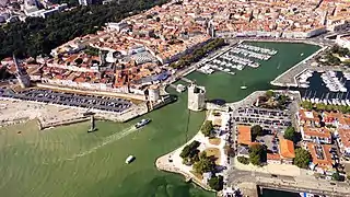 Old harbour, La Rochelle.
Related pages
References
- "Téléchargement du fichier d'ensemble des populations légales en 2019". The National Institute of Statistics and Economic Studies. 28 December 2020.
- "FRANCE: Nouvelle-Aquitaine".
- "Région de la Nouvelle-Aquitaine (75)". Comparateur de territoire (in French). Institut national de la statistique et des études économiques - INSEE. Retrieved 20 March 2017.
- "Chiffres clés" (in French). La Region Nouvelle-Aquitaine. 8 June 2016. Archived from the original on 15 February 2017. Retrieved 20 March 2017.
- "Pic Palas, France/Spain". Peakbagger.com. Retrieved 20 March 2017.
- "France Department High Points". Peakbagger.com. Retrieved 20 March 2017.
- "Populations légales 2014 des départements et des collectivités d'outre-mer" (in French). Institut national de la statistique et des études économiques - INSEE. Retrieved 20 March 2017.
- "Populations légales 2014: Recensement de la population - Population des régions" (in French). Institut national de la statistique et des études économiques - INSEE. Retrieved 20 March 2017.
Other websites
- Regional Council website Archived 2016-01-07 at the Wayback Machine (in French)
- Prefecture of the region