Dordogne
Dordogne (Occitan: Dordonha) is a department in the southwest of France. It is named after the Dordogne river that runs through the department.
Dordogne | |
|---|---|
.JPG.webp) Prefecture building of the Dordogne department, in Périgueux | |
 Flag  Coat of arms | |
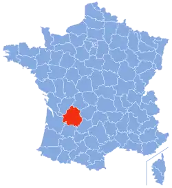 Location of Dordogne in France | |
| Coordinates: 45°0′N 0°40′E | |
| Country | France |
| Region | Nouvelle-Aquitaine |
| Département | 4 March 1790 |
| Prefecture | Périgueux |
| Subprefectures | Bergerac, Nontron, Sarlat-la-Canéda |
| Government | |
| • President | Germinal Peiro[1] |
| Area | |
| • Total | 9,060 km2 (3,500 sq mi) |
| Population (2014)[3] | |
| • Total | 416,350 |
| • Density | 46/km2 (120/sq mi) |
| Demonym(s) | Dordognots, Périgordins |
| Time zone | UTC+1 (CET) |
| • Summer (DST) | UTC+2 (CEST) |
| ISO 3166 code | FR-24 |
| Arrondissements | 4 |
| Cantons | 25 |
| Communes | 545 |
| Website | www.dordogne.fr |
The department is in the region of Nouvelle-Aquitaine. It is between the valley of the Loire river and the Pyrenees. Its prefecture (capital) is Périgueux.
History
Dordogne was formed during the French Revolution on 4 March 1790 with parts of the old province of Périgord. It was divided into nine districts: Belvès, Bergerac, Excideuil, Montignac, Montpon, Nontron, Périgueux, Ribérac and Sarlat.[4]
Bergerac, Périgueux and Sarlat-la-Canéda were alternatively the capital of the department but later it was decided that only Périgueux would be the capital.[4]
Geography
Dordogne is part of the Nouvelle-Aquitaine region. It is the third largest department of Metropolitan France, after Gironde and Landes. It has an area of 9,060 km2 (3,498 sq mi).[2]
The department is bordered by seven departments in two regions:
- Nouvelle-Aquitaine region
- Occitanie region
Places next to Dordogne | |
|---|---|
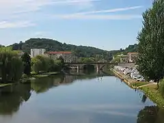
The main river in the department is the Dordogne that gives its name to the department. It runs from east to west through the department. Other rivers are the Isle and the Vézère, both tributaries of the Dordogne.
The highest point in the department is the southwestern summit of the Forêt de Vieillecour (45°34′41″N 1°1′55″E), in northwestern Massif Central near the border with the Haute-Vienne department, with an altitude of 475 m (1,558 ft).[5] The lowest point is in the valley of the Dordogne river and is 16 m (52 ft) high.[6]
Administration
Dordogne is part of the region of Nouvelle-Aquitaine. It is managed by the Departamental Council of Dordogne in Périgueux.
Administrative divisions
There are 4 arrondissements (districts), 25 cantons and 520 communes (municipalities) in Dordogne.[7]
| INSEE code | Arrondissement | Capital | Population[8] (2014) | Area[9] (km²) | Density (Inh./km²) | Communes[10] |
|---|---|---|---|---|---|---|
| 241 | Bergerac | Bergerac | 111,875 | 2,182.0 | 51.3 | 133 |
| 242 | Nontron | Nontron | 40,508 | 1,621.0 | 25.0 | 100 |
| 243 | Périgueux | Périgueux | 189,301 | 3,336.5 | 56.7 | 146 |
| 244 | Sarlat-la-Canéda | Sarlat-la-Canéda | 74,666 | 1,920.6 | 38.9 | 141 |
The following is a list of the 25 cantons of the Dordogne department (with their INSEE codes), following the French canton reorganisation which came into effect in March 2015:[11]
- Bergerac-1 (2401)
- Bergerac-2 (2402)
- Brantôme (2403)
- Coulounieix-Chamiers (2404)
- Le Haut-Périgord Noir (2405)
- Isle-Loue-Auvézère (2406)
- Isle-Manoire (2407)
- Lalinde (2408)
- Montpon-Ménestérol (2409)
- Pays de la Force (2410)
- Pays de Montaigne et Gurson (2411)
- Périgord Central (2412)
- Périgord Vert Nontronnais (2413)
- Périgueux-1 (2414)
- Périgueux-2 (2415)
- Ribérac (2416)
- Saint-Astier (2417)
- Sarlat-la-Canéda (2418)
- Sud-Bergeracois (2419)
- Terrasson-Lavilledieu (2420)
- Thiviers (2421)
- Trélissac (2422)
- Vallée Dordogne (2423)
- Vallée de l'Isle (2424)
- Vallée de l'Homme (2425)
Demographics
The inhabitants of Dordogne are known, in French, as Dordognais (women: Dordognaises).[12] They are also known as Périgordins or Périgoudins.
in 2014, the department of Dordogne had a population of 416,350,[3] for a population density of 46.0 inhabitants/km2. The arrondissement of Périgueux, with 189,301 inhabitants, is by far the largest. The other three, Bergerac, Nontron and Sarlat-la-Canéda, have respectively 111,875, 40,508 and 74,666 inhabitants.[8]
Evolution of the population in Dordogne

The cities in the department with more of 5,000 inhabitants are:
| City | Population[8] (2014) |
Arrondissement |
|---|---|---|
| Périgueux | 30,069 | Périgueux |
| Bergerac | 27,764 | Bergerac |
| Boulazac Isle Manoire | 9,823 | Périgueux |
| Sarlat-la-Canéda | 9,127 | Sarlat-la-Canéda |
| Coulounieix-Chamiers | 8,089 | Périgueux |
| Trélissac | 6,732 | Périgueux |
| Terrasson-Lavilledieu | 6,186 | Sarlat-la-Canéda |
| Saint-Astier | 5,521 | Périgueux |
| Montpon-Ménestérol | 5,480 | Périgueux |
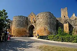
Gallery
.JPG.webp)
.jpg.webp)

References
- "Le Président" (in French). Conseil départemental de la Dordogne. Archived from the original on 26 April 2017. Retrieved 8 March 2017.
- "Département de la Dordogne (24)". Comparateur de territoire (in French). Institut national de la statistique et des études économiques - INSEE. Retrieved 8 March 2017.
- "Populations légales 2014 des départements et des collectivités d'outre-mer" (in French). Institut national de la statistique et des études économiques - INSEE. Retrieved 8 March 2017.
- "Historique de la Dordogne". Le SPLAF (in French). Retrieved 28 March 2015.
- "Forêt de Vieillecour - Sommet Sud-ouest, France". Peakbagger.com. Retrieved 8 March 2017.
- "Présentation de la Dordogne". Comité Départamental du Tourisme de la Dordogne (in French). Archived from the original on 24 March 2015. Retrieved 28 March 2015.
- "Département de la Dordogne (24)" (in French). Institut national de la statistique et des études économiques - INSEE. Retrieved 8 March 2017.
- "Régions, départements, arrondissements, cantons et communes" (PDF). Populations légales 2014 (in French). Institut national de la statistique et des études économiques - INSEE. Retrieved 8 March 2017.
- "Département de la Dordogne (24)". Comparateur de territoire (in French). Institut national de la statistique et des études économiques - INSEE. Retrieved 8 March 2017.
- "Arrêté portant modification des limites territoriales des arrondissements de Bergerac, Nontron, Périgueux et Sarlat-la-Canéda du département de la Dordogne" (PDF) (in French). Préfecture de la Dordogne. Retrieved 8 March 2017.
- "Décret n° 2014-218 du 21 février 2014 portant délimitation des cantons dans le département de la Dordogne" (in French). Legifrance.gouv.fr. 21 February 2014. Retrieved 14 April 2015.
- "Dordogne (24)" (in French). habitants.fr. Retrieved 28 March 2015.
Other websites
- Departamental Council of Dordogne (in French)
- Prefecture official website (in French)
- Comité Départamental du Tourisme de la Dordogne (in French)