Haute-Marne
Haute-Marne is a department in the northeast of France named after the Marner river. It is in the Grand Est region and its prefecture (capital) is the city of Chaumont.
Haute-Marne | |
|---|---|
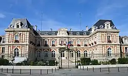 Prefecture building of the Haute-Marne department, in Chaumont | |
 Flag  Coat of arms | |
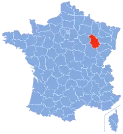 Location of Haute-Marne in France | |
| Coordinates: 48°05′N 05°15′E | |
| Country | France |
| Region | Grand Est |
| Département | 4 March 1790 |
| Prefecture | Chaumont |
| Subprefectures | Langres, Saint-Dizier |
| Government | |
| • President | Bruno Sido |
| Area | |
| • Total | 6,210.6 km2 (2,397.9 sq mi) |
| Population (2014)[2] | |
| • Total | 180,673 |
| • Density | 29/km2 (75/sq mi) |
| Time zone | UTC+1 (CET) |
| • Summer (DST) | UTC+2 (CEST) |
| ISO 3166 code | FR-52 |
| Arrondissements | 3 |
| Cantons | 17 |
| Communes | 427 |
| Website | Haute-Marne Council |
Charles de Gaulle lived until his death in Colombey-les-Deux-Églises.
History
Haute-Marne is one of the original 83 departments created during the French Revolution on 4 March 1790 with Chaumont as is capital. It was formed with parts of the former provinces of Champagne, Burgundy, Lorraine and Franche-Comté.[3]
It was divided in six districts: Bourbonne, Bourmont, Chaumont, Joinville, Langres and Saint-Dizier.
In 1800, with the creation of the arrondissements in France, the six districts were changed into three arrondissements: Chaumont, Langres and Wassy.[3]
After the Battle of Waterloo (18 June 1815), the department was occupied by the Austrian army from June 1815 to November 1818.
On 10 September 1926, the arrondissement of Wassy was eliminated but in 1940 Wassy was made again an arrondissement but the subprefecture was moved to Saint-Dizier.[3]
Geography
The Haute-Marne department is in the Grand Est region. It is bordered by 6 departments in two regions:
- Grand Est region
- Bourgogne-Franche-Comté region
- Haute-Saône (southeast)
- Côte-d'Or (southwest)
Haute-Marne has an area of 6,210.6 km2 (2,398 sq mi),[2] and its highest point is in the Bois de Baissey in the commune Baissey in the southern part of the department; it is 523 m (1,716 ft) high (47°47′19″N 05°11′26″E),[4] and is in the Langres plateau.
The main river is the Marne river; it starts in the Langres plateau and flows through 120 km (75 mi) in the department.
Climate
This area is characterized by climates with few extremes of temperature. The Köppen climate classification type for the climate at Saint-Dizier is a "Marine West Coast Climate" and of the subtype "Cfb".[5]
The average amount of precipitation for the year in Saint-Dizier is 1,450.3 mm (57.1 in). The month with the most precipitation on average is November with 185.4 mm (7.3 in) of precipitation. The month with the least precipitation on average is July with an average of 68.6 mm (2.7 in).
The average temperature for the year in Saint-Dizier is 11.2 °C (52.2 °F). The warmest month, on average, is July with an average temperature of 19.8 °C (67.6 °F). The coolest month on average is January, with an average temperature of 3.2 °C (37.8 °F)
Administration
Haute-Marne is managed by the Departmental Council of Haute-Marne in Chaumont. The department is part of the Grand Est region.
Administrative divisions
There are 5 arrondissements (districts), 23 cantons and 427 communes (municipalities) in Haute-Marne.[6]
| INSEE code | Arrondissement | Capital | Population[7] (2014) | Area[7] (km²) | Density (Inh./km²) | Communes |
|---|---|---|---|---|---|---|
| 521 | Chaumont | Chaumont | 64,970 | 2,476.3 | 26.2 | 159 |
| 522 | Langres | Langres | 44,332 | 2,162.9 | 20.5 | 157 |
| 523 | Saint-Dizier | Saint-Dizier | 71,371 | 1,571.4 | 45.4 | 111 |
The following is a list of the 17 cantons of the Haute-Marne department (with their INSEE codes), following the French canton reorganisation which came into effect in March 2015:[8]
- Bologne (5201)
- Bourbonne-les-Bains (5202)
- Chalindrey (5203)
- Châteauvillain (5204)
- Chaumont-1 (5205)
- Chaumont-2 (5206)
- Chaumont-3 (5207)
- Eurville-Bienville (5208)
- Joinville (5209)
- Langres (5210)
- Nogent (5211)
- Poissons (5212)
- Saint-Dizier-1 (5213)
- Saint-Dizier-2 (5214)
- Saint-Dizier-3 (5215)
- Villegusien-le-Lac (5216)
- Wassy (5217)
Demographics
The inhabitants of the Haute-Marne department are known, in French, as Haut-Marnais (women: Haut-Marnaises),[9]
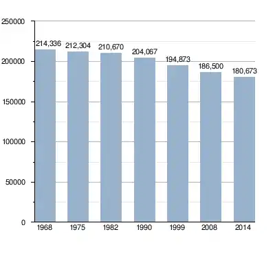
Haute-Marne had a population, in 2014, of 180,673,[2] for a population density of 29.1 inhabitants/km2. The arrondissement of Saint-Dizier, with 71,371 inhabitants, is the arrondissement with more inhabitants.[7]
Evolution of the population in Haute-Marne
The communes with more inhabitants in the Haute-Marne department are:[10]
| City | Population (2014) |
Arrondissement |
|---|---|---|
| Saint-Dizier | 25,505 | Saint-Dizier |
| Chaumont | 22,560 | Chaumont |
| Langres | 7,877 | Langres |
| Nogent | 3,865 | Chaumont |
| Joinville | 3,407 | Saint-Dizier |
| Wassy | 2,893 | Saint-Dizier |
| Chalindrey | 2,437 | Langres |
| La Porte du Der | 2,335 | Saint-Dizier |
| Eurville-Bienville | 2,134 | Saint-Dizier |
| Bourbonne-les-Bains | 2,106 | Langres |
| Éclaron-Braucourt-Sainte-Livière | 2,083 | Saint-Dizier |
Gallery
 View from the walls of Langres
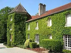 De Gaulle's house in Colombey-les-Deux-Églises
.jpg.webp) Joinville
Joinville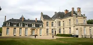 Château of Cirey-sur-Blaise
References
- "La commission permanentr" (in French). Conseil départamental de la Haute-Marne. Archived from the original on 13 January 2017. Retrieved 7 December 2016.
- "Département de la Haute-Marne (52)". Comparateur de territoire (in French). Institut national de la statistique et des études économiques - INSEE. Retrieved 9 July 2016.
- "Historique de la Haute-Marne". Le SPLAF (in French). Retrieved 7 December 2016.
- "Bois de Baissey, France". Peakbagger.com. Retrieved 7 December 2016.
- "Saint-Dizier, France - Köppen Climate Classification". Weatherbase. Retrieved 7 December 2016.
- "Département de la Haute-Marne (52)". Géographie administrative et d'étude (in French). Institut national de la statistique et des études économiques - INSEE. Retrieved 9 July 2017.
- "Département de la Haute-Marne (52) et Arrondissements". Comparateur de territoire (in French). Institut national de la statistique et des études économiques - INSEE. Retrieved 9 July 2016.
- "Décret n° 2014-163 du 17 février 2014 portant délimitation des cantons dans le département de la Haute-Marne" (in French). Légifrance.gouv.fr. Retrieved 7 December 2016.
- "Habitants du départment: Haute-Marne (52)" (in French). habitants.fr. Retrieved 7 December 2016.
- "Régions, départements, arrondissements, cantons et communes" (PDF). Populations légales 2014 (in French). Institut national de la statistique et des études économiques - INSEE. Retrieved 9 July 2017.
Other websites
- Departmental Council website Archived 2016-11-25 at the Wayback Machine (in French)
- Prefecture of the Haute-Marne department (in French)
- Tourism in Haute-Marne Archived 2013-03-15 at the Wayback Machine