Haute-Loire
Haute-Loire (Occitan: Naut Léger) is a département in the Auvergne-Rhône-Alpes region of south-central France. It is named after the Loire river.
Haute-Loire | |
|---|---|
 Flag  Coat of arms | |
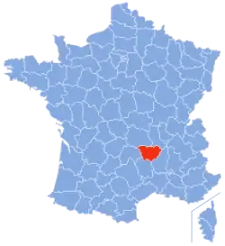 Location of Haute-Loire in France | |
| Coordinates: 45°0′N 4°0′E | |
| Country | France |
| Region | Auvergne-Rhône-Alpes |
| Département | 4 March 1790 |
| Prefecture | Le Puy-en-Velay |
| Subprefectures | Brioude, Yssingeaux |
| Government | |
| • President | Jean-Pierre Marcon[1] |
| Area | |
| • Total | 4,977.1 km2 (1,921.7 sq mi) |
| Population (2014)[3] | |
| • Total | 226,565 |
| • Density | 46/km2 (120/sq mi) |
| Demonym | Altiligériens |
| Time zone | UTC+1 (CET) |
| • Summer (DST) | UTC+2 (CEST) |
| ISO 3166 code | FR-43 |
| Arrondissements | 3 |
| Cantons | 19 |
| Communes | 257 |
| Website | www.hauteloire.fr |
History
The department of Haute-Loire was created on 4 March 1790 with three districts: Le Puy, Brioude and Yssingeaux. The capital was Le Puy.[4] The new department was formed with territories of three historic provinces: the Languedoc, the Auvergne and the Lyonnais.[5]
In 1800, with the creation of the arrondissements in France, the three districts were changed into three arrondissements: Le Puy, Brioude and Yssingeaux.[4]
On 10 September 1926, the arrondissement of Yssingeaux was eliminated but became again an arrondissement in 1942.[4]
On 18 March 1988, the name of Le Puy was changed to Le Puy-en-Velay.
Geography
The Haute-Loire is part of the Auvergne-Rhône-Alpes region. It has an area of 4,977.1 km2 (1,922 sq mi).[2]
The department is surrounded by 5 departments in 2 regions:
- Auvergne-Rhône-Alpes region
- Loire (north)
- Puy-de-Dôme (north)
- Ardèche (east)
- Cantal (west)
- Occitanie region
- Lozère (south)
The highest point in the department is Mont Mézenc (44°54′40″N 04°11′27″E); it is 1,753 m (5,751 ft) high.[6] It is in the southeast of the department, on the border with the Ardèche department.
The main rivers in Haute-Loire are:
- Loire, that flows through the eastern part of the department and ends in the Atlantic Ocean. Its Drainage basin covers two-thirds of the eastern part of the department.
- Allier, a tributary of the Loire that flows through the western part of the department.
Climate
The Köppen climate classification type for the climate at Le Puy-en-Velay is an "Oceanic climate" (also known as Maritime Temperate climate) and of the subtype Cfb.
Administration
Haute-Loire is managed by the Departmental Council of Haute-Loire in Le Puy-en-Velay. The department is part of the Auvergne-Rhône-Alpes region.
Administrative divisions
There are 3 arrondissements (districts), 19 cantons and 257 communes (municipalities) in Haute-Loire.[7]
| INSEE code | Arrondissement | Capital | Population[8] (2014) | Area[9] (km²) | Density (Inh./km²) | Communes |
|---|---|---|---|---|---|---|
| 431 | Brioude | Brioude | 45,848 | 1,886.8 | 24.3 | 111 |
| 432 | Le Puy-en-Velay | Le Puy-en-Velay | 96,041 | 1,930.7 | 49.7 | 102 |
| 433 | Yssingeaux | Yssingeaux | 84,676 | 1,159.7 | 73.0 | 44 |
The following is a list of the 19 cantons of the Haute-Loire department (with their INSEE codes), following the French canton reorganisation which came into effect in March 2015:[10]
- Aurec-sur-Loire (4301)
- Bas-en-Basset (4302)
- Boutières (4303)
- Brioude (4304)
- Deux Rivières et Vallées (4305)
- Emblavez-et-Meygal (4306)
- Gorges de l'Allier-Gévaudan (4307)
- Mézenc (4308)
- Monistrol-sur-Loire (4309)
- Pays de Lafayette (4310)
- Plateau du Haut-Velay granitique (4311)
- Le Puy-en-Velay-1 (4312)
- Le Puy-en-Velay-2 (4313)
- Le Puy-en-Velay-3 (4314)
- Le Puy-en-Velay-4 (4315)
- Saint-Paulien (4316)
- Sainte-Florine (4317)
- Velay volcanique (4318)
- Yssingeaux (4319)
Demographics
The inhabitants of Haute-Loire are known, in French, as Altiligériens (women: Altiligériennes).[11]
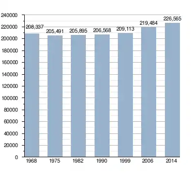
Haute-Loire had a population, in 2014, of 226,565,[3] for a population density of 45.5 inhabitants/km2. The arrondissement of Le Puy-en-Velay, with 96,041 inhabitants, is the arrondissement with more inhabitants.[8]
Evolution of the population in Haute-Loire
The communes in the department with more inhabitants are:[8]
| City | Population (2014)[8] |
Arrondissement |
|---|---|---|
| Le Puy-en-Velay | 18,634 | Le Puy-en-Velay |
| Monistrol-sur-Loire | 8,808 | Yssingeaux |
| Yssingeaux | 7,105 | Yssingeaux |
| Brioude | 6,700 | Brioude |
| Aurec-sur-Loire | 6,035 | Yssingeaux |
| Sainte-Sigolène | 5,952 | Yssingeaux |
| Bas-en-Basset | 4,314 | Yssingeaux |
| Brives-Charensac | 4,153 | Le Puy-en-Velay |
| Saint-Just-Malmon | 4,153 | Yssingeaux |
| Langeac | 3,758 | Brioude |
Gallery

 Lavaudieu
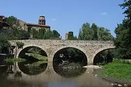
 Lavoûte-Chilhac
 Polignac
References
- "Le Président". Haute-Loire, le Département. Retrieved 27 September 2017.
- "Département de la Haute-Loire (43)". Comparateur de territoire (in French). Institut national de la statistique et des études économiques - INSEE. Retrieved 27 September 2017.
- "Populations légales 2014 des départements et des collectivités d'outre-mer" (in French). Institut national de la statistique et des études économiques - INSEE. Retrieved 27 September 2017.
- "Historique de la Haute-Loire". Le SPLAF (in French). Retrieved 27 September 2017.
- "Histoire des départements". Haute-Loire, le Département. Retrieved 27 September 2017.
- "Mont Mézenc, France". Peakbagger.com. Retrieved 19 October 2016.
- "Département de la Haute-Loire (43)" (in French). Institut national de la statistique et des études économiques - INSEE. Retrieved 27 September 2017.
- "Régions, départements, arrondissements, cantons et communes" (PDF). Populations légales 2014 (in French). Institut national de la statistique et des études économiques - INSEE. Retrieved 27 September 2017.
- "Département de la Haute-Loire (43) et Arrondissements". Comparateur de territoire (in French). Institut national de la statistique et des études économiques - INSEE. Retrieved 27 September 2017.
- "Décret n° 2014-162 du 17 février 2014 portant délimitation des cantons dans le département de la Haute-Loire" (in French). Légifrance.gouv.fr. Retrieved 27 September 2017.
- "Habitants du départment: Haute-Loire (07)" (in French). habitants.fr. Retrieved 28 September 2017.
Other websites
- Departmental Council website (in French)
- Prefecture website (in French)