Saône-et-Loire
Saône-et-Loire is a department in the centre of France. It is in the Bourgogne-Franche-Comté region. It is named after the two main rivers in the department: the Saône and the Loire rivers.
Saône-et-Loire | |
|---|---|
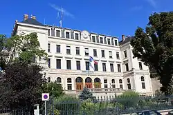 Prefecture building of the Saône-et-Loire department, in Mâcon | |
 Flag  Coat of arms | |
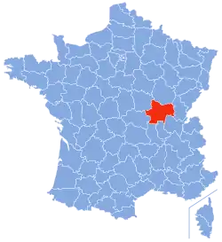 Saône-et-Loire in France | |
| Coordinates: 46°40′N 04°42′E | |
| Country | France |
| Region | Bourgogne-Franche-Comté |
| Département | 4 March 1790 |
| Prefecture | Mâcon |
| Subprefectures | Autun, Chalon-sur-Saône, Charolles, Louhans |
| Government | |
| • President | André Accary[1] |
| Area | |
| • Total | 8,574.7 km2 (3,310.7 sq mi) |
| Population (2014)[3] | |
| • Total | 555,788 |
| • Density | 65/km2 (170/sq mi) |
| Demonym | Saône-et-Loiriens |
| Time zone | UTC+1 (CET) |
| • Summer (DST) | UTC+2 (CEST) |
| ISO 3166 code | FR-71 |
| Arrondissements | 5 |
| Cantons | 29 |
| Communes | 567 |
| Website | www.saoneetloire71.fr |
The largest city in the department is Chalon-sur-Saône. The prefecture (capital) is the smaller city of Mâcon.
History
Saône-et-Loire is one of the original 83 departments created during the French Revolution on 4 March 1790 with Mâcon as its capital.[4] It was formed from combined parts of the old provinces of southern Burgundy and Bresse, uniting lands which have no true geographical unity.
It was divided in seven districts: Autun, Bourbon-Lancy, Chalon-sur-Saône, Charolles, Louhans, Mâcon and Semur-en-Brionnais.[5] That same year, the name of the district Semur-en-Brionnais was changed to Marcigny.[4]
In 1800, with the creation of the arrondissements in France, the seven districts were changed into five arrondissements: Mâcon, Autun, Chalon-sur-Saône, Charolles and Louhans.[4]
After the Battle of Waterloo (18 June 1815), the department was occupied by the Austrian army from June 1815 to November 1818.
On 10 September 1926, the arrondissement of Louhans was eliminated but in 1942 it became again an arrondissement of the department.[4]
Geography

Saône-et-Loire is part of the Bourgogne-Franche-Comté region. It has an area of 8,574.7 km2 (3,311 sq mi);[2] the seventh largest department of France.
The department borders with 7 other departments in two regions:
- Bourgogne-Franche-Comté region
- Auvergne-Rhône-Alpes region
There are five natural regions in the department:
- Autunois, to the northwest; it is the region around Autun.
- Charolais, to the southwest and around the commune of Charolles.
- Chalonnais, to the north with Chalon-sur-Saône as the main city.
- Mâconnais, to the south and around the commune of Mâcon.
- Bresse, to the east of the Saône river with Louhans as the main city.
The main rivers in the department are the Loire, that makes most of the western border of the department and that flows to the north, into the Atlantic Ocean; and the Saône, in the eastern part of the department and that flows to the south and joins the Rhône river at Lyon.
Climate
The Köppen climate classification type for the climate at Charnay-lès-Mâcon is an "Oceanic climate" (also known as Maritime Temperate climate) and of the subtype Cfb.[6]
The average temperature for the year in Charnay-lès-Mâcon, to the west of Mâcon and where is the local airport, is 11.7 °C (53.1 °F). The warmest month, on average, is July with an average temperature of 21.1 °C (70.0 °F). The coolest month, on average is January, with an average temperature of 2.8 °C (37.0 °F).
The average amount of precipitation for the year in Charnay-lès-Mâcon is 866.1 mm (34.10 in). The month with the most precipitation on average is October with 96.5 mm (3.80 in) of precipitation. The month with the least precipitation on average is August with an average of 50.8 mm (2.00 in).[6]
Administration
Saône-et-Loire is managed by the Departmental Council of Saône-et-Loire in Mâcon. The department is part of the Bourgogne-Franche-Comté region.
Administrative divisions
There are 5 arrondissements (districts), 29 cantons and 567 communes (municipalities) in Saône-et-Loire.[7]
| INSEE code | Arrondissement | Capital | Population[8] (2014) | Area[9] (km²) | Density (Inh./km²) | Communes |
|---|---|---|---|---|---|---|
| 711 | Autun | Autun | 86,693 | 1,900.3 | 45.6 | 83 |
| 712 | Chalon-sur-Saône | Chalon-sur-Saône | 200,084 | 1,726.0 | 115.9 | 149 |
| 713 | Charolles | Charolles | 99,381 | 2,500.3 | 39.7 | 135 |
| 714 | Louhans | Louhans | 55,567 | 1,248.5 | 44.5 | 79 |
| 715 | Mâcon | Mâcon | 114,063 | 1,199.6 | 95.1 | 121 |
The following is a list of the 29 cantons of the Saône-et-Loire department (with their INSEE codes), following the French canton reorganisation which came into effect in March 2015:[10]
- Autun-1 (7101)
- Autun-2 (7102)
- Blanzy (7103)
- Chagny (7104)
- Chalon-sur-Saône-1 (7105)
- Chalon-sur-Saône-2 (7106)
- Chalon-sur-Saône-3 (7107)
- La Chapelle-de-Guinchay (7108)
- Charolles (7109)
- Chauffailles (7110)
- Cluny (7111)
- Le Creusot-1 (7112)
- Le Creusot-2 (7113)
- Cuiseaux(7114)
- Digoin (7115)
- Gergy (7116)
- Givry (7117)
- Gueugnon (7118)
- Hurigny (7119)
- Louhans (7120)
- Mâcon-1 (7121)
- Mâcon-2 (7122)
- Montceau-les-Mines (7123)
- Ouroux-sur-Saône (7124)
- Paray-le-Monial (7125)
- Pierre-de-Bresse (7126)
- Saint-Rémy (7127)
- Saint-Vallier (7128)
- Tournus (7129)
Demographics
The inhabitants of Saône-et-Loire are known, in French, as Saône-et-Loiriens (women: Saône-et-Loiriennes).[11]
Saône-et-Loire had a population, in 2014, of 555,788,[3] for a population density of 64.8 inhabitants/km2. The arrondissement of Chalon-sur-Saône, with 200,084 inhabitants, is the arrondissement with more inhabitants.[8]
Evolution of the population in Saône-et-Loire

The cities with more than inhabitants in the department are:[8]
| City | Population[8] (2014) |
Arrondissement |
|---|---|---|
| Chalon-sur-Saône | 44,985 | Chalon-sur-Saône |
| Mâcon | 33,456 | Mâcon |
| Le Creusot | 21,991 | Autun |
| Montceau-les-Mines | 18,902 | Chalon-sur-Saône |
| Autun | 13,955 | Autun |
| Paray-le-Monial | 9,133 | Charolles |
| Saint-Vallier | 8,783 | Chalon-sur-Saône |
| Digoin | 8,005 | Charolles |
| Gueugnon | 7,276 | Charolles |
| Charnay-lès-Mâcon | 6,969 | Mâcon |
Gallery
_032.JPG.webp)
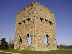
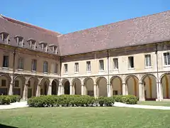
 Antun Cathedral.
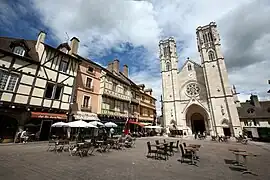
 Chalon-sur-Saône and the Saône river.
 Cows outside the Maison du Charolais, Charolles.
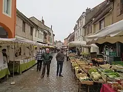 Market in Louhans.
References
- "Le président" (in French). Conseil Départemental de Saône-et-Loire. Retrieved 21 June 2017.
- "Département de Saône-et-Loire (71)". Comparateur de territoire (in French). Institut national de la statistique et des études économiques - INSEE. Retrieved 21 June 2017.
- "Populations légales 2014: Recensement de la population - Régions, départements, arrondissements, cantons et communes" (in French). Institut national de la statistique et des études économiques - INSEE. Retrieved 21 June 2017.
- "Historique de Saône-et-Loire". Le SPLAF (in French). Retrieved 8 November 2014.
- "Histoire". Saône-et-Loire - Le Départment (in French). Retrieved 8 November 2014.
- "Charnay-lès-Mâcon, France - Climate Summary". Weatherbase. Retrieved 9 November 2014.
- "Département de Saône-et-Loire (71)". Géographie administrative et d'étude (in French). Institut national de la statistique et des études économiques - INSEE. Retrieved 21 June 2017.
- "Régions, départements, arrondissements, cantons et communes" (PDF). Populations légales 2014 (in French). Institut national de la statistique et des études économiques - INSEE. Retrieved 21 June 2017.
- "Département de Saône-et-Loire (71)". Comparateur de territoire (in French). Institut national de la statistique et des études économiques - INSEE. Retrieved 21 June 2017.
- "Décret n° 2014-182 du 18 février 2014 portant délimitation des cantons dans le département de Saône-et-Loire" (in French). Legifrance.gouv.fr. 13 February 2014. Retrieved 21 June 2017.
- "Saône-et-Loire (71)" (in French). habitants.fr. Retrieved 9 November 2014.
Related pages
Other websites
- Departmental Council website (in French)
- Prefecture website (in French)
- Bourgogne du Sud - Tourism en Saône-et-Loire Archived 2014-12-18 at the Wayback Machine