Charente
Charente (Saintongeais: Chérente, Occitan: Charanta) is a department in southwestern France, in the Nouvelle-Aquitaine region.
Charente | |
|---|---|
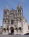
 Prefecture building of the Charente department, in Angoulême | |
 Flag  Coat of arms | |
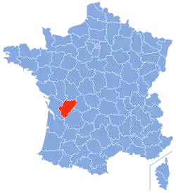 Location of Charente in France | |
| Coordinates: 45°50′N 0°20′E | |
| Country | France |
| Region | Nouvelle-Aquitaine |
| Département | 4 March 1790 |
| Prefecture | Angoulême |
| Subprefectures | Cognac, Confolens |
| Government | |
| • President | François Bonneau |
| Area | |
| • Total | 5,956 km2 (2,300 sq mi) |
| Population (2014)[2] | |
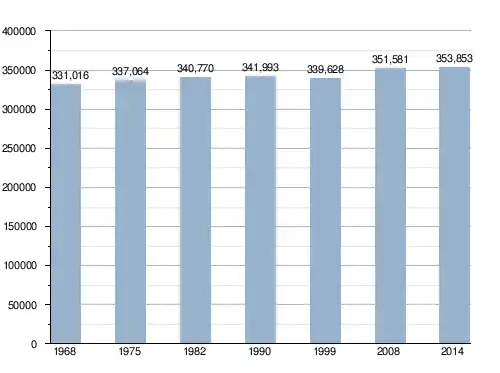
| • Total | 353,853 |
| • Density | 59/km2 (150/sq mi) |
| Demonym | Charentais |
| Time zone | UTC+1 (CET) |
| • Summer (DST) | UTC+2 (CEST) |
| ISO 3166 code | FR-16 |
| Arrondissements | 3 |
| Cantons | 19 |
| Communes | 383 |
| Website | http://www.lacharente.fr |
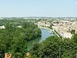
It is named after the Charente river, the most important river in the department. The two largest towns of the department, Angoulême and Cognac, are along this river.
History
Charente is one of the 83 French departments made during the French revolution, on 4 March 1790. It was created from the old province of Angoumois with lands around Angoulême.
The new department had six districts: Ruffec, Confolens, La Rochefoucauld, Angoulême, Barbezieux and Cognac. The capital (now prefecture) was Angoulême.[3]
In 1800, with the creation of the arrondissements in France, the six districts were changed into five arrondissements: Angoulême, Barbezieux, Cognac, Confolens and Ruffec.[3]
On 10 September 1926, the arrondissements of Barbezieux and Ruffec were eliminated.[3]
Geography
Charente is part of the Nouvelle-Aquitaine region. It has an area of 5,956 km2 (2,300 sq mi).[1]
The highest point of the department is Rocher aux Oiseaux, 368 m (1,207 ft) high, in the commune of Montrollet; the lowest point is in the valley of the Charente river, commune of Merpins, and is 8 m (26 ft) high.
The department is bordered by the departments: Deux-Sèvres, Vienne, Haute-Vienne, Dordogne and Charente-Maritime.
Places next to Charente | |
|---|---|
The main river in the department is the Charente that gives its name to the department. Other rivers are the Dronne and the Vienne.
Climate
The climate of Cognac is an oceanic climate with template summers, Cfb (Marine West Coast Climate) in the Köppen climate classification.[4]
The average amount of precipitation for the year in Cognac is 777.2 mm (30.6 in). The month with the most precipitation on average is November with 86.4 mm (3.4 in) of precipitation. The month with the least precipitation on average is July with an average of 48.3 mm (1.9 in).
The average temperature for the year in Cognac is 13.3 °C (55.9 °F). The warmest month, on average, is July with an average temperature of 21.1 °C (70.0 °F). The coolest month on average is January, with an average temperature of 6.1 °C (43.0 °F).
Administration
The department is managed by the Departmental Council of the Charente in Angoulême. Charente is part of the region of Nouvelle-Aquitaine.
Administrative divisions
There are 3 arrondissements (districts), 19 cantons and 383 communes (municipalities) in Charente.[5]
| INSEE code | Arrondissement | Capital | Population[6] (2014) | Area[7] (km²) | Density (Inh./km²) | Communes |
|---|---|---|---|---|---|---|
| 161 | Angoulême | Angoulême | 197,377 | 2,217.1 | 89.0 | 117 |
| 162 | Cognac | Cognac | 92,224 | 1,471.2 | 62.7 | 116 |
| 163 | Confolens | Confolens | 64,252 | 2,267.7 | 28.3 | 150 |
The following is a list of the 19 cantons of the Charente department (with their INSEE codes), following the French canton reorganisation which came into effect in March 2015:[8]
- Angoulême-1 (1601)
- Angoulême-2 (1602)
- Angoulême-3 (1603)
- Boëme-Échelle (1604)
- Boixe-et-Manslois (1605)
- Charente-Bonnieure (1606)
- Charente-Champagne (1607)
- Charente-Nord (1608)
- Charente-Sud (1609)
- Charente-Vienne (1610)
- Cognac-1 (1611)
- Cognac-2 (1612)
- La Couronne (1613)
- Gond-Pontouvre (1614)
- Jarnac (1615)
- Touvre-et-Braconne (1616)
- Tude-et-Lavalette (1617)
- Val de Nouère (1618)
- Val de Tardoire (1619)
Demographics
The inhabitants of Charente are known, in French, as Charentais (women: Charentaises).[9]
Charente has a population, in 2014, of 353,853,[2] for a population density of 59.4 inhabitants/km2. The arrondissement of Angoulême, with 197,377 inhabitants, is by far the largest. The other two, Cognac and Confolens, have respectively 92,224 and 64,252 inhabitants.[6]
Evolution of the population in Charente-Maritime
The 10 main cities in the department are:
| City | Population[6] (2014) |
Arrondissement |
|---|---|---|
| Angoulême | 41,955 | Angoulême |
| Cognac | 18,717 | Cognac |
| Soyaux | 9,322 | Angoulême |
| La Couronne | 7,636 | Angoulême |
| Ruelle-sur-Touvre | 7,292 | Angoulême |
| Saint-Yrieix-sur-Charente | 7,210 | Angoulême |
| Gond-Pontouvre | 5,907 | Angoulême |
| L' Isle-d'Espagnac | 5,412 | Angoulême |
| Champniers | 5,251 | Angoulême |
| Barbezieux-Saint-Hilaire | 4,730 | Cognac |
Economy
The cognac is an alcoholic drink, a kind of brandy. It is made from grapes. It is made mainly around the city of Cognac.


References
- "Département de la Charente (16)". Comparateur de territoire (in French). Institut national de la statistique et des études économiques - INSEE. Retrieved 31 May 2017.
- "Populations légales 2014: Recensement de la population - Régions, départements, arrondissements, cantons et communes" (in French). Institut national de la statistique et des études économiques - INSEE. Retrieved 31 May 2017.
- "Historique de la Charente". Le SPLAF (in French). Retrieved 12 July 2016.
- "Cognac, France - Köppen Climate Classification". Weatherbase. Retrieved 12 July 2016.
- "Département de la Charente (16)". Géographie administrative et d'étude (in French). Institut national de la statistique et des études économiques - INSEE. Retrieved 31 May 2017.
- "Régions, départements, arrondissements, cantons et communes" (PDF). Populations légales 2014 (in French). Institut national de la statistique et des études économiques - INSEE. Retrieved 31 May 2017.
- "Département de la Charente (16)". Comparateur de territoire (in French). Institut national de la statistique et des études économiques - INSEE. Retrieved 31 May 2017.
- "Décret n° 2014-195 du 20 février 2014 portant délimitation des cantons dans le département de la Charente" (in French). Légifrance.gouv.fr. Retrieved 12 July 2016.
- "Charente (16)" (in French). habitants.fr. Retrieved 12 July 2016.
Other websites
- Departmental Council website (in French)
- Prefecture website (in French)