Cantal
Cantal is a French department in south-central France in the Auvergne-Rhône-Alpes region. Its prefecture is Aurillac.
Cantal | |
|---|---|
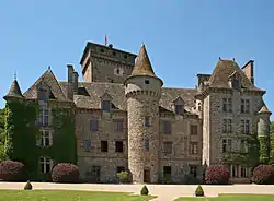 Chateau of Pesteil in Polminhac, Cantal | |
 Flag  Coat of arms | |
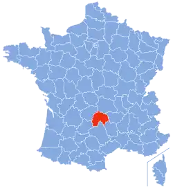 Location of Cantal in France | |
| Coordinates: 45°2′N 3°6′E | |
| Country | France |
| Region | Auvergne-Rhône-Alpes |
| Département | 4 March 1790 |
| Prefecture | Aurillac |
| Subprefectures | Mauriac, Saint-Flour |
| Government | |
| • President | Vincent Descoeur |
| Area | |
| • Total | 5,726 km2 (2,211 sq mi) |
| Population (2014)[2] | |
| • Total | 146,618 |
| • Rank | 78th |
| • Density | 26/km2 (66/sq mi) |
| Demonym | Cantalians |
| Time zone | UTC+1 (CET) |
| • Summer (DST) | UTC+2 (CEST) |
| ISO 3166 code | FR-12 |
| Arrondissements | 3 |
| Cantons | 15 |
| Communes | 255 |
| Website | http://www.cantal.fr/ |
It is named after the Mounts of Cantal, a group of mountains in the Massif Central.
History
Cantal is one of the 83 French departments made during the French revolution, on 4 March 1790. It was created with part of the territory of the old province of Auvergne in south central France. It was divided in four districts: Aurillac, Mauriac, Murat and Saint-Flour; its capital in Saint-Flour, alternating with Aurillac.[3]
In 1794, Saint-Flour became the only capital but, in 1795, the capital was moved to Aurillac.
In 1800, with the creation of the arrondissements in France, the districts were changed into arrondissements: Aurillac, Mauriac, Murat and Saint-Flour. On 10 September 1926, the arrondissement of Murat was eliminated.[3]
Geography
Cantal is part of the Auvergne-Rhône-Alpes region, in south central France, with an area of 5,726 km2 (2,211 sq mi).
The department borders with 3 regions and 7 other departments:[3]
- Auvergne-Rhône-Alpes region
- Puy-de-Dôme (north)
- Haute-Loire (northeast)
- Occitanie region
- Nouvelle-Aquitaine region
- Corrèze (west)
Places next to Cantal | ||||||||||
|---|---|---|---|---|---|---|---|---|---|---|
| ||||||||||
Cantal is in the middle half of the central plateau (Massif Central) of France where is the Mounts of Cantal mountain range, a group of extinct volcanoes. The highest point in the Cantal mountains, and in the department is Plomb du Cantal (45°3′33″N 2°45′41″E) that is 1,855 m (6,086 ft) high.[4] Other high mountains near Plomb du Cantal in the Cantal department are:
- Puy du Rocher (45°4′N 2°46′E), 1,813 m (5,948 ft) high;
- Puy de Peyre Arse (45°6′37″N 2°42′39″E), 1,806 m (5,925 ft) high; and
- Puy Mary (45°6′34″N 2°40′34″E), 1,783 m (5,850 ft) high.
The lowest point of the department, 250 m (820 ft), is in the valley of the Lot river where it leaves the department.
The main rivers are the Alagnon, a tributary to the Allier; the Célé and Truyère rivers, tributaries to the Lot river; and the Cère and Rhue rivers, tributaries to the Dordogne river.
Climate
The climate of Cantal has with few extremes of temperature and ample precipitation in all months. It belongs to the subtype Cfb (Marine West Coast Climate) in the Köppen climate classification.
The average temperature for the year in Aurillac, at an altitude of 633 m (2,077 ft), is 10.2 °C (50.4 °F). The warmest month, on average, is July with an average temperature of 18.3 °C (64.9 °F). The coolest month on average is January, with an average temperature of 2.9 °C (37.2 °F).
The average amount of precipitation for the year in Aurillac is 856 mm (33.7 in). The month with the most precipitation on average is December with 109.2 mm (4.3 in) of precipitation. The month with the least precipitation on average is June with an average of 45.7 mm (1.8 in).[5]
Administration
Cantal is part of the region of Auvergne-Rhône-Alpes. The department is managed by the Departamental Council of the Cantal in Aurillac.
Administrative divisions
There are 3 arrondissements (districts), 15 cantons and 255 communes (municipalities) in Cantal.
| INSEE code | Arrondissement | Capital | Population[6] (2014) | Area (km²) | Density (Inh./km²) | Communes |
|---|---|---|---|---|---|---|
| 151 | Aurillac | Aurillac | 82,347 | 1,937 | 42.5 | 94 |
| 152 | Mauriac | Mauriac | 26,192 | 1,278 | 20.5 | 55 |
| 153 | Saint-Flour | Saint-Flour | 38,079 | 2,511 | 15.2 | 106 |
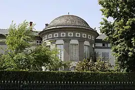 Prefecture of Cantal in Aurillac.
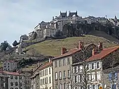 Saint-Flour upper town.
The following is a list of the 15 cantons of the Cantal department (with their INSEE codes),[6] following the French canton reorganisation which came into effect in March 2015:[7]
- Arpajon-sur-Cère (1501)
- Aurillac-1 (1502)
- Aurillac-2 (1503)
- Causses-Rougiers (1504)
- Mauriac (1505)
- Maurs (1506)
- Murat (1507)
- Naucelles (1508)
- Neuvéglise (1509)
- Riom-ès-Montagnes (1510)
- Saint-Flour-1 (1511)
- Saint-Flour-2 (15012)
- Saint-Paul-des-Landes (15013)
- Vic-sur-Cère (1514)
- Ydes (1514)
Demographics
The inhabitants of Cantal are known, in French, as Cantaliens (women: Cantaliennes) or Cantalous (women: Cantalouses).[8]
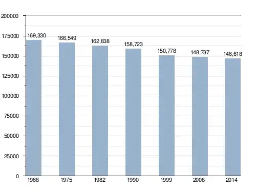
Cantal has a population, in 2014, of 146,618,[2] for a population density of 25.6 inhabitants/km2. The arrondissement of Aurillac, with 82,347 inhabitants, is by far the largest. The other two, Saint-Flour and Mauriac, have respectively 38,079 and 26,192 inhabitants.[6]
The city with more people living in it is the capital, Aurillac (26,135). The subprefectures of Saint-Flour and Mauriac have, respectively, 6,643 and 3,682 inhabitants.[6]
Evolution of the population in Cantal
The 10 most important cities in the department are:
| City | Population[6] (2014) |
Arrondissement |
|---|---|---|
| Aurillac | 26,135 | Aurillac |
| Saint-Flour | 6,643 | Saint-Flour |
| Arpajon-sur-Cère | 6,233 | Aurillac |
| Ytrac | 4,121 | Aurillac |
| Mauriac | 3,682 | Mauriac |
| Riom-ès-Montagnes | 2,661 | Mauriac |
| Maurs | 2,170 | Aurillac |
| Jussac | 2,010 | Aurillac |
| Naucelles | 1,942 | Aurillac |
| Vic-sur-Cère | 1,917 | Aurillac |
References
- "L'Assemblée". Conseil départemental du Cantal (in French). Retrieved 21 January 2017.
- "Populations légales 2014 des départements et des collectivités d'outre-mer" (in French). Institut national de la statistique et des études économiques - INSEE. Retrieved 9 January 2017.
- "Historique du Cantal". Le SPLAF (in French). Retrieved 21 January 2017.
- "Plomb du Cantal, France". Peakbagger.com. Retrieved 21 January 2017.
- "Aurillac, France - Köppen Climate Classification". Weatherbase. Retrieved 21 January 2017.
- "Régions, départements, arrondissements, cantons et communes" (PDF). Populations légales 2014 (in French). Institut national de la statistique et des études économiques - INSEE. Retrieved 21 January 2017.
- "Décret n° 2014-149 du 13 février 2014 portant délimitation des cantons dans le département du Cantal" (in French). Légifrance.gouv.fr. Retrieved 21 January 2017.
- "Cantal" (in French). habitants.fr. Retrieved 21 January 2017.
Other websites
- Departamental Council website (in French)
- Prefecture website Archived 2011-05-14 at the Wayback Machine (in French)