Henderson County, North Carolina
Henderson County is a county in the U.S. state of North Carolina. In 2020, 116,281 people lived there.[1] Its county seat is Hendersonville.[2]
Henderson County | |
|---|---|
 Henderson County Courthouse | |
| Motto(s): "Outdoor adventures and more" | |
 Location within the U.S. state of North Carolina | |
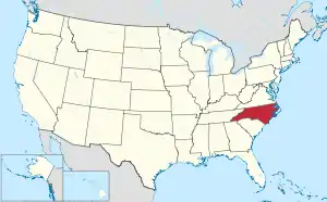 North Carolina's location within the U.S. | |
| Coordinates: 35°20′11″N 82°28′47″W | |
| Country | |
| State | |
| Founded | 1838 |
| Named for | Leonard Henderson |
| Seat | Hendersonville |
| Largest community | Hendersonville |
| Area | |
| • Total | 375.09 sq mi (971.5 km2) |
| • Land | 372.95 sq mi (965.9 km2) |
| • Water | 2.14 sq mi (5.5 km2) 0.57% |
| Population (2020) | |
| • Total | 116,281 |
| • Density | 311.79/sq mi (120.38/km2) |
| Time zone | UTC−5 (Eastern) |
| • Summer (DST) | UTC−4 (EDT) |
| Congressional district | 11th |
| Website | www |
History
The county was made in 1838 from the southern part of Buncombe County. It was named for Leonard Henderson, Chief Justice of the North Carolina Supreme Court from 1829 to 1833.
Government
Henderson County is part of the local Land-of-Sky Regional Council of governments.
Bordering counties
These counties are bordered to Henderson County:
- Buncombe County - north
- Rutherford County - northeast
- Polk County - east
- Greenville County, South Carolina - south
- Transylvania County - west
- Haywood County - northwest
Communities
These communities are in Henderson County:
Cities
- Hendersonville
- Saluda
Towns
- Fletcher
- Laurel Park
- Mills River
Village
- Flat Rock
Census-designated places
- Balfour
- Barker Heights
- Dana
- East Flat Rock
- Edneyville
- Etowah
- Fruitland
- Gerton
- Hoopers Creek
- Horse Shoe
- Mountain Home
- Valley Hill
Unincorporated communities
- Bat Cave
- Chestnut Hill
- Mountain Page
- Naples
- Tuxedo
- Zirconia
- Bearwallow
Townships
- Blue Ridge
- Clear Creek
- Crab Creek
- Edneyville
- Green River
- Hendersonville
- Hoopers Creek
- Mills River
References
- "QuickFacts: Henderson County, North Carolina". United States Census Bureau. Retrieved January 18, 2024.
- National Association of Counties. "NACo County Explorer". Retrieved January 18, 2024.
Other websites
Wikimedia Commons has media related to Henderson County, North Carolina.

This article is issued from Wikipedia. The text is licensed under Creative Commons - Attribution - Sharealike. Additional terms may apply for the media files.