Warren County, North Carolina
Warren County is a county in the U.S. state of North Carolina. It is on the northern border with Virginia. In 2020, 18,642 people lived there.[1] Its county seat is Warrenton.[2]
Warren County | |
|---|---|
.jpg.webp) Warren County Courthouse in Warrenton | |
 Location within the U.S. state of North Carolina | |
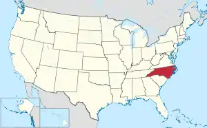 North Carolina's location within the U.S. | |
| Coordinates: 36°23′53″N 78°06′00″W | |
| Country | |
| State | |
| Founded | 1779 |
| Named for | Joseph Warren |
| Seat | Warrenton |
| Largest community | Warrenton |
| Area | |
| • Total | 444.30 sq mi (1,150.7 km2) |
| • Land | 429.39 sq mi (1,112.1 km2) |
| • Water | 14.91 sq mi (38.6 km2) 3.36% |
| Population (2020) | |
| • Total | 18,642 |
| • Density | 43.42/sq mi (16.76/km2) |
| Time zone | UTC−5 (Eastern) |
| • Summer (DST) | UTC−4 (EDT) |
| Congressional district | 1st |
| Website | www |
References
- "QuickFacts: Warren County, North Carolina". United States Census Bureau. Retrieved January 18, 2024.
- "Find a County". National Association of Counties. Retrieved 2011-06-07.

This article is issued from Wikipedia. The text is licensed under Creative Commons - Attribution - Sharealike. Additional terms may apply for the media files.