Caswell County, North Carolina
Caswell County is a county in the U.S. state of North Carolina. In 2020, 22,736 people lived there.[1] Its county seat is Yanceyville.
Caswell County | |
|---|---|
 Old Caswell County Courthouse in Yanceyville | |
| Motto: "Preserving the Past – Embracing the Future" | |
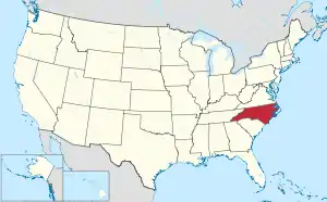
 Location within the U.S. state of North Carolina | |
 North Carolina's location within the U.S. | |
| Coordinates: 36°23′39″N 79°20′23″W | |
| Country | |
| State | |
| Founded | June 1, 1777 |
| Named for | Richard Caswell |
| Seat | Yanceyville |
| Largest community | Yanceyville |
| Area | |
| • Total | 428.71 sq mi (1,110.4 km2) |
| • Land | 425.37 sq mi (1,101.7 km2) |
| • Water | 3.34 sq mi (8.7 km2) 0.78% |
| Population (2020) | |
| • Total | 22,736 |
| • Density | 53.45/sq mi (20.64/km2) |
| Time zone | UTC−5 (Eastern) |
| • Summer (DST) | UTC−4 (EDT) |
| Congressional districts | 4th, 6th |
| Website | www |
History
Caswell County was made in 1777 from the northern part of Orange County. In 1792 the eastern half of Caswell County was made into Person County.
Government
Caswell County is part of the local Piedmont Triad Council of Governments.
Connected counties
These counties are connected to Caswell County:
- Pittsylvania County, Virginia - north
- Halifax County, Virginia - northeast
- Person County, North Carolina - east
- Orange County, North Carolina - southeast
- Alamance County, North Carolina - southwest
- Rockingham County, North Carolina - west
References
- "QuickFacts: Caswell County, North Carolina". United States Census Bureau. Retrieved January 17, 2024.
Other websites
- Caswell County government official website Archived 2007-04-05 at the Wayback Machine
- Caswell County Historical Association

This article is issued from Wikipedia. The text is licensed under Creative Commons - Attribution - Sharealike. Additional terms may apply for the media files.