Buncombe County, North Carolina
Buncombe County is a county in the U.S. state of North Carolina. In 2020, 269,452 people lived there.[1] Its county seat is Asheville.
Buncombe County | |
|---|---|
.jpg.webp) Buncombe County Courthouse in Asheville | |
| Motto: "People To Match Our Mountains" | |
 Location within the U.S. state of North Carolina | |
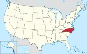 North Carolina's location within the U.S. | |
| Coordinates: 35°36′34″N 82°31′50″W | |
| Country | |
| State | |
| Founded | 1792 |
| Named for | Edward Buncombe |
| Seat | Asheville |
| Largest city | Asheville |
| Area | |
| • Total | 659.95 sq mi (1,709.3 km2) |
| • Land | 656.50 sq mi (1,700.3 km2) |
| • Water | 3.45 sq mi (8.9 km2) 0.52% |
| Population (2020) | |
| • Total | 269,452 |
| • Density | 410.37/sq mi (158.44/km2) |
| Time zone | UTC−5 (Eastern) |
| • Summer (DST) | UTC−4 (EDT) |
| Congressional district | 11th |
| Website | www |
History
The county was made in 1791 from parts of Burke County and Rutherford County.
In 1808 the western part of Buncombe County was made into Haywood County. In 1833 parts of Burke County and Buncombe County were combined to make Yancey County, and in 1838 the southern part of Buncombe County was made into Henderson County. In 1851 parts of Buncombe County and Yancey County were combined to make Madison County. And, in 1925 a small part of McDowell County was made into a part of Buncombe County.
Law and government
Buncombe County is part of the local Land-of-Sky Regional Council of governments.
Big roads
These are the most important roads in Buncombe County:
 Interstate 26
 Interstate 40
 U.S. Highway 74
 U.S. Highway 70
 U.S. Highway 23
 U.S. Highway 19
 U.S. Highway 25
Connected counties
These counties are connected to Buncombe County:
- Madison County, North Carolina - north
- Yancey County, North Carolina - northeast
- McDowell County, North Carolina - east
- Rutherford County, North Carolina - southeast
- Henderson County, North Carolina - south
- Haywood County, North Carolina - west
Cities and towns
These cities and towns are in Buncombe County:
References
- "QuickFacts: Buncombe County, North Carolina". United States Census Bureau. Retrieved January 17, 2024.