Brunswick County, North Carolina
Brunswick County is a county in the U.S. state of North Carolina. In 2020, 136,693 people lived there.[1] Its county seat is Bolivia.
Brunswick County | |
|---|---|
_16.jpg.webp) Brunswick County Courthouse | |
 Location within the U.S. state of North Carolina | |
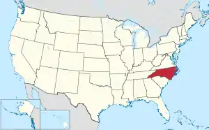 North Carolina's location within the U.S. | |
| Coordinates: 34°02′20″N 78°13′40″W | |
| Country | |
| State | |
| Founded | March 9, 1764 |
| Named for | Duchy of Brunswick-Lüneburg |
| Seat | Bolivia |
| Largest community | Leland |
| Area | |
| • Total | 1,049.54 sq mi (2,718.3 km2) |
| • Land | 850.08 sq mi (2,201.7 km2) |
| • Water | 199.46 sq mi (516.6 km2) 19.00% |
| Population (2020) | |
| • Total | 136,693 |
| • Density | 160.80/sq mi (62.09/km2) |
| Time zone | UTC−5 (Eastern) |
| • Summer (DST) | UTC−4 (EDT) |
| Congressional district | 7th |
| Website | www |
History
The county was made in 1764 from parts of Bladen County and New Hanover County.
Government
Brunswick County is part of the local Cape Fear Council of Governments.
Connected counties
These counties are connected to Brunswick County:
- Pender County, North Carolina - north-northeast
- New Hanover County, North Carolina - east
- Horry County, South Carolina - southwest
- Columbus County, North Carolina - northwest
Cities and towns
These cities and towns are in Brunswick County:
- Bald Head Island
- Belville
- Boiling Spring Lakes
- Bolivia
- Calabash
- Carolina Shores
- Caswell Beach
- Holden Beach
- Leland
- Navassa
- Northwest
- Oak Island
- Ocean Isle Beach
- Sandy Creek
- Shallotte
- Southport
- St. James
- Sunset Beach
- Varnamtown
- Winnabow
References
- "QuickFacts: Brunswick County, North Carolina". United States Census Bureau. Retrieved January 17, 2024.
Other websites
- Brunswick County government official website Archived 2014-01-01 at the Wayback Machine

This article is issued from Wikipedia. The text is licensed under Creative Commons - Attribution - Sharealike. Additional terms may apply for the media files.