Forsyth County, North Carolina
Forsyth County is a county located in the U.S. state of North Carolina. As of the 2020 census, the population was 382,590.[1] It is the fourth-most populous county in North Carolina. Its county seat is Winston-Salem.[2]
Forsyth County | |
|---|---|
.jpg.webp) Forsyth County Courthouse in Winston-Salem | |
 Flag | |
 Location within the U.S. state of North Carolina | |
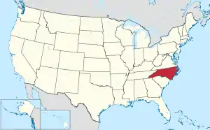 North Carolina's location within the U.S. | |
| Coordinates: 36°07′57″N 80°15′25″W | |
| Country | |
| State | |
| Founded | 1849 |
| Named for | Benjamin Forsyth |
| Seat | Winston-Salem |
| Largest community | Winston-Salem |
| Area | |
| • Total | 412.35 sq mi (1,068.0 km2) |
| • Land | 407.85 sq mi (1,056.3 km2) |
| • Water | 4.50 sq mi (11.7 km2) 1.09% |
| Population (2020) | |
| • Total | 382,590 |
| • Density | 937.7/sq mi (362.0/km2) |
| Time zone | UTC−5 (Eastern) |
| • Summer (DST) | UTC−4 (EDT) |
| Congressional districts | 5th, 6th |
| Website | www |
History
The county was made in 1849 from Stokes County. It was named after Colonel Benjamin Forsyth, who was killed in the War of 1812.[3]
Bordering counties
These counties are bordered to Forsyth County:
- Stokes County - north
- Rockingham County - northeast
- Guilford County - east
- Davidson County - south
- Davie County - southwest
- Yadkin County - west
- Surry County - northwest
Communities
These communities are in Forsyth County:
Cities
- Winston-Salem (county seat)
- High Point (mostly in Guilford County, also in Randolph County, Davidson County)
- King (mostly in Stokes County)
Towns
- Bethania
- Kernersville (partially in Guilford County)
- Lewisville
- Rural Hall
- Walkertown
Villages
- Clemmons
- Tobaccoville (also in Stokes County)
Census-designated place
- Germanton
Unincorporated communities
- Belews Creek
- Donnaha
- Dozier
- Pfafftown
- Seward
- Stanleyville
- Union Cross
- Vienna
References
- "QuickFacts: Forsyth County, North Carolina". United States Census Bureau. Retrieved January 18, 2024.
- "Find a County". National Association of Counties. Archived from the original on 2011-05-31. Retrieved 2011-06-07.
- Gannett, Henry (1905). The Origin of Certain Place Names in the United States. Govt. Print. Off. pp. 128.
Other websites
Wikimedia Commons has media related to Forsyth County, North Carolina.
Municipalities and communities of Forsyth County, North Carolina, United States | ||
|---|---|---|
| Cities |
|  Map of North Carolina highlighting Forsyth County |
| Towns |
| |
| Villages |
| |
| Townships |
| |
| CDP |
| |
| Unincorporated communities |
| |
| Footnotes | ‡This populated place also has portions in an adjacent county or counties | |

This article is issued from Wikipedia. The text is licensed under Creative Commons - Attribution - Sharealike. Additional terms may apply for the media files.