Bertie County, North Carolina
Bertie County (said like BURT-TEE) is a county in the U.S. state of North Carolina. In 2020, 17,934 people lived there.[1] Its county seat is Windsor.
Bertie County | |
|---|---|
 Manor House of Hope Plantation near Windsor. | |
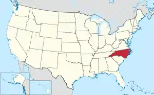
 Location within the U.S. state of North Carolina | |
 North Carolina's location within the U.S. | |
| Coordinates: 36°03′33″N 76°57′45″W | |
| Country | |
| State | |
| Founded | 1739 |
| Named for | James Bertie and/or Henry Bertie |
| Seat | Windsor |
| Largest community | Windsor |
| Area | |
| • Total | 741.31 sq mi (1,920.0 km2) |
| • Land | 699.18 sq mi (1,810.9 km2) |
| • Water | 42.13 sq mi (109.1 km2) 5.61% |
| Population (2020) | |
| • Total | 17,934 |
| • Density | 25.65/sq mi (9.90/km2) |
| Time zone | UTC−5 (Eastern) |
| • Summer (DST) | UTC−4 (EDT) |
| Congressional district | 1st |
| Website | www |
Government
Bertie County is part of the Mid-East Commission local council of governments.
Connected Counties
These counties are connected to Bertie County:
- Hertford County, North Carolina - north
- Chowan County, North Carolina - east
- Washington County, North Carolina - southeast
- Martin County, North Carolina - southwest
- Halifax County, North Carolina - west
- Northampton County, North Carolina - northwest
Cities and towns
These cities and towns are in Bertie County:
- Askewville
- Aulander
- Colerain
- Kelford
- Powellsville
- Merry Hill
- Roxobel
- Windsor
References
- "QuickFacts: Bertie County, North Carolina". United States Census Bureau. Retrieved January 17, 2024.
Other websites

This article is issued from Wikipedia. The text is licensed under Creative Commons - Attribution - Sharealike. Additional terms may apply for the media files.