Niger
Niger or the Niger[12][13] (/niːˈʒɛər/ or /ˈnaɪdʒər/;[14][15] French: [niʒɛʁ]), officially the Republic of the Niger,[12][13] is a country in western Africa. The capital is Niamey, and the official language is French. It is surrounded by Algeria and Libya to the north, Chad to the east, Nigeria and Benin to the south, and Burkina Faso and Mali to the west. Niger is landlocked, meaning it has no coastline. Niger gets its name from the Niger River, whose name possibly comes from the Berber word "River of Rivers".[16]
Republic of the Niger
| |
|---|---|
 Coat of arms
| |
Motto:
| |
| Anthem: L'Honneur de la Patrie | |
.svg.png.webp) Location of Niger (dark green) | |
| Capital and largest city | Niamey 13°32′N 2°05′E |
| Official languages | French |
| National languages[1] |
|
| Demonym(s) | Nigerien (/niːˈʒɛəriən/ [2] |
| Government | Unitary semi-presidential republic under a military junta |
| Omar Tchiani[lower-alpha 1] | |
| Ali Lamine Zeine[4] | |
| Legislature | National Assembly |
| Independence from France | |
• Republic proclaimed | 18 December 1958 |
• Declared | 3 August 1960 |
| Area | |
• Total | 1,267,000 km2 (489,000 sq mi) (21st) |
• Water (%) | 0.02 |
| Population | |
• 2020 estimate | 23,196,002 (57th) |
• 2012 census | 17,138,707 |
• Density | 12.1/km2 (31.3/sq mi) |
| GDP (PPP) | 2018 estimate |
• Total | $23.475 billion[5] (140th) |
• Per capita | $1,213[6] (183rd) |
| GDP (nominal) | 2018 estimate |
• Total | $9.869 billion[7] (136th) |
• Per capita | $510[8] (179th) |
| Gini (2014) | medium · 70th |
| HDI (2019) | low · 189th |
| Currency | West African CFA franc (XOF) |
| Time zone | UTC+1 (WAT) |
| Driving side | right[11] |
| Calling code | +227 |
| ISO 3166 code | NE |
| Internet TLD | .ne |
| |

The Mali Empire and the Songhai Empire both had land in what is now Niger. Later France controlled the land that is now Niger. Niger has a population, or the number of people living in an area, of 15,306,252 and an area of 1,267,000 square kilometres. Much of Niger is desert.
After a military coup in 2010, Niger is now a democratic, multi-party state. Most of the people live in rural areas, and have little access to advanced education.
Niger is one of the poorest countries in the world with a lack of contraception. 41.4% live in poverty. Hunger plagues the country.
Niger’s main exports are uranium ore, livestock, cowpeas and onions. Millet and sorghum are grown in the south, as well as cassava and sugarcane. Rice is grown in the Niger River valley. Peanuts are the most important cash crop. Other important crops are cotton and pulses.
Niger is home to the critically endangered addax antelope. West African giraffes are the only giraffes in West Africa that exist in Niger.
Geography
Niger is on the border between the Sahara and Sub-Saharan regions. Niger's area is 1,267,000 square kilometres (489,191 sq mi) of which 300 square kilometres (116 sq mi) is water. It is the world's twenty-second largest country. Niger borders seven countries. The longest border is with Nigeria to the south.
The lowest point is the Niger River, with an elevation of 200 metres (656 ft). The highest point is Mont Idoukal-n-Taghès in the Aïr Mountains at 2,022 m (6,634 ft).
Regions
- Northern Niger: Agadez Region
- South-Central Niger: Maradi Region, Tahoua Region, Zinder Region
- South-Eastern Niger: Diffa Region, Zinder Region
- South-Western Niger: Tillabéri Region, Dosso Region, Niamey, Tahoua Region
Zinder Region and Tahoua Region are intermediates between Central Niger.
Cities
This table shows cities with a population over 10,000, according to 2001 census.
Climate
Niger's subtropical climate is mainly very hot and dry. Much of it is covered by desert. In the extreme south there is a tropical climate on the edges of the Niger River basin. The land is mostly desert plains and sand dunes. There is flat to rolling savanna in the south and hills in the north.
Wildlife
 Gazelle
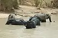 Elephants
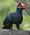 Violet turaco
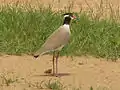 Black-headed lapwing
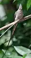 Blue-naped mousebird
Demographics
There are several ethnic groups in Niger:
Education
The literacy rate (the amount of the adult population who can read or write) of Niger is among the lowest in the world. In 2005 it was estimated to be only 28.7% (42.9% male and 15.1% female).[19] Primary education in Niger is required for six years.[20] The primary school enrollment and attendance rates are low, particularly for girls.[20] Children are often made to work rather than attend school. This is particularly true during planting or harvest periods.
Notes
- Disputed by Hassoumi Massaoudou[3]
References
- République du Niger, "Loi n° 2001-037 du 31 décembre 2001 fixant les modalités de promotion et de développement des langues nationales." L'aménagement linguistique dans le monde Archived 19 October 2018 at the Wayback Machine (accessed 21 September 2016)
- "Nigerien – definition of Nigerien in English from the Oxford Dictionaries". Archived from the original on 1 March 2018. Retrieved 1 March 2018.
- Peter, Laurence (27 July 2023). "Niger soldiers announce coup on national TV". BBC. Retrieved 27 July 2023.
- https://www.africanews.com/2023/08/08/niger-junta-appoints-new-prime-minister/
- "Report for Selected Country Groups and Subjects (PPP valuation of country GDP)". IMF. Retrieved 14 November 2018.
- World Economic Outlook Database, January 2018 Archived 3 May 2018 at the Wayback Machine, International Monetary Fund Archived 14 February 2006 at Archive-It. Database updated on 12 April 2017. Accessed on 21 April 2017.
- "World Economic Outlook Database. Report for Selected Countries and Subjects". International Monetary Fund. 17 April 2018.
- World Economic Outlook Database, April 2018 Archived 26 April 2018 at the Wayback Machine, International Monetary Fund. Accessed on 17 April 2018.
- World Bank GINI index Archived 9 February 2015 at the Wayback Machine, accessed on 21 January 2016.
- Human Development Report 2020 The Next Frontier: Human Development and the Anthropocene (PDF). United Nations Development Programme. 15 December 2020. pp. 343–346. ISBN 978-92-1-126442-5. Retrieved 16 December 2020.
- Which side of the road do they drive on? Archived 14 April 2012 at the Wayback Machine Brian Lucas. August 2005. Retrieved 28 January 2009.
- "ISO 3166". ISO Online Browsing Platform. Archived from the original on 17 June 2016. Retrieved 12 May 2017.
- "UNGEGN World Geographical Names". United Nations Statisticsc Division. 1 March 2017. Archived from the original on 28 July 2011. Retrieved 12 May 2017.
- How Do You Pronounce "Niger"? Archived 14 March 2012 at the Wayback Machine from Slate.com, retrieved 4 March 2012
- "Niger." The American Heritage® Dictionary of the English Language, Fourth Edition. 2003. Houghton Mifflin Company 22 February 2013 thefreedictionary.com/Niger Archived 12 May 2013 at the Wayback Machine
- Hunwick, John O. (2003) [1999]. Timbuktu and the Songhay Empire: Al-Sadi's Tarikh al-Sudan down to 1613 and other contemporary documents. Leiden: Brill. p. 275 Fn 22. ISBN 90-04-11207-3.
- Population figures from citypopulation.de, citing (2001) Institut National de la Statistique du Niger.
- fallingrain.com.
- "Africa :: Niger — The World Factbook - Central Intelligence Agency". www.cia.gov. Archived from the original on 2020-04-24. Retrieved 2008-02-19.
- "Niger" Archived 2008-12-05 at the Wayback Machine. 2001 Findings on the Worst Forms of Child Labor. Bureau of International Labor Affairs, U.S. Department of Labor (2002). This article incorporates text from this source, which is in the public domain.
Other websites
- Niger - CIA world factbook Archived 2020-04-24 at the Wayback Machine
.svg.png.webp)