Cameroon
Cameroon (officially called the Republic of Cameroon) is a country in Central Africa. Its capital is Yaoundé. The largest city in Cameroon is Douala. The population of Cameroon is about 20 million. Cameroon's president is Paul Biya. They speak nearly 250 languages in Cameroon. French and English are the official languages.
Republic of Cameroon | |
|---|---|
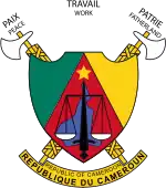
 Coat of arms
| |
| Motto: "Paix – Travail – Patrie" (French) "Peace – Work – Fatherland" | |
| Anthem: Ô Cameroun, Berceau de nos Ancêtres (French) (English: "O Cameroon, Cradle of our Forefathers") | |
.svg.png.webp) | |
| Capital | Yaoundé 3°52′N 11°31′E |
| Largest city | Yaoundé (city proper) Douala (metropolitan area) |
| Official languages | |
| Recognised regional languages | Cameroonian Pidgin English, Fula, Ewondo, Chadian Arabic, Camfranglais |
| Ethnic groups |
|
| Religion (2018) |
|
| Demonym(s) | Cameroonian |
| Government | Unitary dominant-party semi-presidential constitutional republic |
| Paul Biya | |
| Joseph Ngute | |
| Legislature | Parliament |
| Senate | |
| National Assembly | |
| Independence from France | |
• Declared | 1 January 1960 |
• Union with part of the former British Cameroons | 1 October 1961 |
| Area | |
• Total | 475,442 km2 (183,569 sq mi) (53rd) |
• Water (%) | 0.57 |
| Population | |
• 2020 estimate | 26,545,864 [1] (51st) |
• 2005 census | 17,463,836[2] |
• Density | 39.7/km2 (102.8/sq mi) (167th) |
| GDP (PPP) | 2018 estimate |
• Total | $95.068 billion[3] (93rd) |
• Per capita | $3,820[3] (152nd) |
| GDP (nominal) | 2018 estimate |
• Total | $38.445 billion[3] (98th) |
• Per capita | $1,544[3] (152nd) |
| Gini (2014) | 46.6[4] high |
| HDI (2019) | medium · 153rd |
| Currency | Central African CFA franc (XAF) |
| Time zone | UTC+1 (WAT) |
| Driving side | right |
| Calling code | +237 |
| ISO 3166 code | CM |
| Internet TLD | .cm |
| |
Geography

At 475,442 square kilometres (183,569 sq mi), Cameroon is the world's 53rd-largest country.[6] It is about the size of Papua New Guinea.[7] The country is in Central and West Africa on the Bight of Bonny, part of the Gulf of Guinea and the Atlantic Ocean. The country's neighbours are Nigeria to the west; Chad to the northeast; the Central African Republic to the east; and Equatorial Guinea, Gabon, and the Republic of the Congo to the south.
Regions
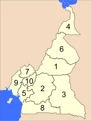
The constitution divides Cameroon into 10 regions. On 12 November 2008, the President changed the divisions from provinces to regions.[8] Each region is headed by a presidentially appointed governor.
The regions are divided into 58 divisions. These are headed by presidentially appointed divisional officers.
 Regions of Cameroon | |||||||||||||||||||||||||||||||||||||||||||||||||||||||||||||||||||||||||||||
|
Cities
Some of the largest cities in Cameroon are:
| Ranking | Name | Population |
|---|---|---|
| 1. | Douala | 2,000,000 |
| 2. | Yaoundé | 1,600,000 |
| 3. | Garoua | 450,000 |
| 4. | Bafoussam | 350,000 |
| 5. | Maroua | 327,000 |
| 6. | Bamenda | 299,600 |
| 7. | Ngaoundéré | 185,700 |
Languages
The official languages of Cameroon are French and English. It is part of both the British Commonwealth and La Francophonie. Most people speak French, English is only spoken in the Northwest and Southwest regions of the country, formerly under British control.
References
- United Nations. "World Population Prospects 2020".
- "Rapport de présentation des résultats définitifs" (PDF) (in French). Institut national de la statistique. p. 6. Archived from the original (PDF) on 13 August 2012. Retrieved 21 July 2012.
- "World Economic Outlook Database, October 2018". IMF.org. International Monetary Fund. Retrieved 7 February 2019.
- "GINI index (World Bank estimate)". databank.worldbank.org. World Bank. Archived from the original on 31 March 2018. Retrieved 7 February 2019.
- Human Development Report 2020 The Next Frontier: Human Development and the Anthropocene (PDF). United Nations Development Programme. 15 December 2020. pp. 343–346. ISBN 978-92-1-126442-5. Retrieved 16 December 2020.
- Demographic Yearbook 1.
- "Rank Order – Area".
- Décret N° 2008/376 du 12 novembre 2008, President of the Republic website. Accessed 9 June 2009.

.svg.png.webp)