Akrotiri and Dhekelia
Akrotiri and Dhekelia | |
|---|---|
| Sovereign Base Areas of Akrotiri and Dhekelia | |
 Flag  Emblem | |
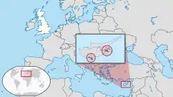
 Location of Akrotiri and Dhekelia (red) | |
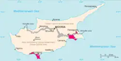
 Location of Akrotiri (left) and Dhekelia (right) in pink on Cyprus (pink, grey, and beige) | |
| Sovereign state | |
| Treaty of Establishment | 16 August 1960 |
| Capital | Episkopi Cantonment |
| Largest civilian settlement | Akrotiri |
| Official languages | English |
| Common languages | |
| Government | De facto stratocratic dependency under a constitutional monarchy |
• Monarch | Charles III |
• Administrator | Major-General Robert Thomson ex officio |
| Government of the United Kingdom | |
• Minister | James Cleverly |
| Area | |
• Total | 256[1] km2 (99 sq mi) |
| Population | |
• 2020[2] estimate | 18,195[2] (not ranked) |
| Currency | Euro (€) (EUR) |
| Time zone | UTC+02:00 (EET) |
| UTC+03:00 (EEST) | |
| Driving side | left |
| Calling code | 357 |
| UK postcode | BFPO 57 / BF1 2AT (Akrotiri) BFPO 58 / BF1 2AU (Dhekelia) |
| Geopolitical Entities and Codes (GEC) | AX |
Akrotiri and Dhekelia are two British overseas territories that border the Republic of Cyprus. They are used as military bases by the United Kingdom. The bases were kept by the United Kingdom after Cyprus changed from being a colony in the British Empire, to being an independent republic. The United Kingdom kept them because of the important location of Cyprus in the Mediterranean Sea.
Military bases
The smallest of the bases is known as Akrotiri Sovereign Base Area or even the Western Sovereign Base Area.[2]
References
- Bowman, John S.; Goult, Herman W.; Stather Hunt, David Wathen. "Akrotiri - British military enclave, Cyprus - Britannica". www.britannica.com. Encyclopedia Britannica. Archived from the original on 19 June 2022. Retrieved 19 June 2022.
- "Akrotiri". The World Factbook. Central Intelligence Agency. 6 June 2022. Archived from the original on 19 June 2022. Retrieved 19 June 2022.
This article is issued from Wikipedia. The text is licensed under Creative Commons - Attribution - Sharealike. Additional terms may apply for the media files.