Sonneberg (district)
Sonneberg is a Landkreis (rural district) in the south of Thuringia, Germany.
Landkreis Sonneberg | |
|---|---|
 Coat of arms | |
 | |
| Coordinates: 50°25′N 11°10′E | |
| Country | Germany |
| State | Thuringia |
| Capital | Sonneberg |
| Area | |
| • Total | 433 km2 (167 sq mi) |
| Population (31 December 2022)[1] | |
| • Total | 56,922 |
| • Density | 130/km2 (340/sq mi) |
| Time zone | UTC+01:00 (CET) |
| • Summer (DST) | UTC+02:00 (CEST) |
| Vehicle registration | SON |
| Website | http://www.lkson.de |
History
The district was created in 1868 when districts were created in Saxe-Meiningen. In 1952 part of the district was incorporated into the newly created district Neuhaus am Rennweg. This district was dissolved again in 1994 and the district Sonneberg did regain its old size.
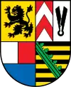
Coat of arms
|
The coat of arms shows symbols of the historic states which make up the territory of the district. In the topleft is the lion as symbol of the county of Meißen. In the top right is the symbol of the Lords of Sonneberg, which includes a sheep scissor. In the bottom left the symbol of the Counts of Schaumberg-Rauenstein; in the bottom right is the coat of arms of Saxony. |
Towns and municipalities
| Towns | Municipalities |
|---|---|
|
|
References
- "Bevölkerung der Gemeinden, erfüllenden Gemeinden und Verwaltungsgemeinschaften in Thüringen Gebietsstand: 31.12.2022" (in German). Thüringer Landesamt für Statistik. June 2023.
This article is issued from Wikipedia. The text is licensed under Creative Commons - Attribution - Sharealike. Additional terms may apply for the media files.