Saalfeld-Rudolstadt
Saalfeld-Rudolstadt is a Landkreis (district) in the south of Thuringia, Germany.
Landkreis Saalfeld-Rudolstadt | |
|---|---|
 Coat of arms | |
 | |
| Coordinates: 50°40′N 11°20′E | |
| Country | Germany |
| State | Thuringia |
| Capital | Saalfeld |
| Area | |
| • Total | 1,035 km2 (400 sq mi) |
| Population (31 December 2022)[1] | |
| • Total | 101,494 |
| • Density | 98/km2 (250/sq mi) |
| Time zone | UTC+01:00 (CET) |
| • Summer (DST) | UTC+02:00 (CEST) |
| Vehicle registration | SLF |
| Website | http://www.sa-ru.de |
History
The district dates back to the Landratsamt Saalfeld, which was created in 1868, and in 1922 it was converted into the Landkreis. Also in 1922 the district Rudolstadt was created. Both districts were merged in the local government changes of 1994.
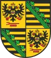
Coat of arms
|
As Saalfeld was the capital of the duchy Saxony-Saalfeld, the Saxon coat of arms is displayed in the top-right and bottom-left quarter of the coat of arms. The other two quarters show the coat of arms of the Princes of Schwarzburg-Rudolstadt. The double-headed imperial eagle is the symbol for the title as imperial prince, the comb in bottom shows that the princes were also Imperial Stable Masters. |
Towns and municipalities
| Verwaltungsgemeinschaft-free towns | and municipalities | |
|---|---|---|
|
|
|
| Verwaltungsgemeinschaften | ||
|---|---|---|
|
1. Bergbahnregion/Schwarzatal
2. Lichtetal am Rennsteig
|
3. Mittleres Schwarzatal
|
4. Probstzella-Lehesten-Marktgölitz
|
| 1seat of the Verwaltungsgemeinschaft;2town | ||
References
- "Bevölkerung der Gemeinden, erfüllenden Gemeinden und Verwaltungsgemeinschaften in Thüringen Gebietsstand: 31.12.2022" (in German). Thüringer Landesamt für Statistik. June 2023.
Other websites
- Official website Archived 2005-09-01 at the Wayback Machine (German)
| Urban districts | |
|---|---|
| Rural districts | |
This article is issued from Wikipedia. The text is licensed under Creative Commons - Attribution - Sharealike. Additional terms may apply for the media files.