Ilm-Kreis
Ilm-Kreis is a district in Thuringia, Germany.
Ilm-Kreis | |
|---|---|
 Coat of arms | |
| Country | Germany |
| State | Thuringia |
| Capital | Arnstadt |
| Government | |
| • District admin. | Petra Enders (Ind.) |
| Area | |
| • Total | 805.11 km2 (310.85 sq mi) |
| Population (31 December 2022)[1] | |
| • Total | 106,776 |
| • Density | 130/km2 (340/sq mi) |
| Time zone | UTC+01:00 (CET) |
| • Summer (DST) | UTC+02:00 (CEST) |
| Vehicle registration | IK, ARN, IL |
| Website | ilm-kreis.de |
History
In medieval times the territory was ruled by the counts of Henneberg and the princes of Schwarzburg, two local dynasties. While Ilmenau was ruled by Henneberg, Arnstadt belonged to Schwarzburg. When the Henneberg family became extinct in 1583, Ilmenau was acquired by Saxony. The principality of Schwarzburg was split up between family members into several tiny states. One of those states (Schwarzburg-Arnstadt) was based in Arnstadt; it was founded in 1574 and existed until 1716, when it became part of Schwarzburg-Sondershausen. It became part of Thuringia when the Freestate of Thuringia was founded in 1920.
The district was founded in 1920 (under the name Arnstadt); it was divided in 1952 into the districts of Arnstadt and Ilmenau, but joined together again in 1994.
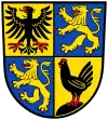
Coat of arms
|
The coat of arms displays:
|
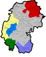
Towns and municipalities
| Verwaltungsgemeinschaft-free towns | and municipalities |
|---|---|
|
|
| Verwaltungsgemeinschaften | ||
|---|---|---|
|
1. Geratal
2. Großbreitenbach
|
3. Langer Berg
4. Oberes Geratal
|
5. Rennsteig
6. Riechheimer Berg
|
| 1seat of the Verwaltungsgemeinschaft;2town | ||
Other websites
- Official website (German, English)
References
- "Bevölkerung der Gemeinden, erfüllenden Gemeinden und Verwaltungsgemeinschaften in Thüringen Gebietsstand: 31.12.2022" (in German). Thüringer Landesamt für Statistik. June 2023.
| Urban districts | |
|---|---|
| Rural districts | |