Osage County, Oklahoma
Osage County is the largest county in the U.S. state of Oklahoma. As of 2020, 45,818 people lived there.[1] Its county seat is Pawhuska. The county covers the same area as the Osage Nation reservation.
Osage County | |
|---|---|
 Osage County Courthouse | |
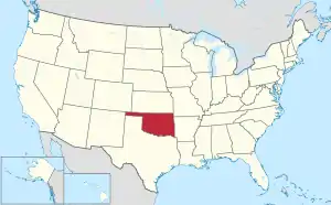
 Location within the U.S. state of Oklahoma | |
 Oklahoma's location within the U.S. | |
| Coordinates: 36°38′N 96°24′W | |
| Country | |
| State | |
| Founded | 1907 |
| Named for | Osage Nation |
| Seat | Pawhuska |
| Largest city | Hominy |
| Area | |
| • Total | 2,304 sq mi (5,970 km2) |
| • Land | 2,246 sq mi (5,820 km2) |
| • Water | 58 sq mi (150 km2) 2.5% |
| Population (2020) | |
| • Total | 45,818 |
| • Density | 20/sq mi (7.7/km2) |
| Congressional district | 3rd |
Geography
The county has a total area of 2,304 square miles.
Places
Cities
- Barnsdall
- Bartlesville
- Hominy
- Pawhuska
- Ponca City
- Sand Springs
- Shidler
- Tulsa
Towns
- Avant
- Burbank
- Fairfax
- Foraker
- Grainola
- Osage
- Prue
- Skiatook (part)
- Webb City
- Wynona
Other
- Bowring
- Carter Nine
- Gray Horse
- McCord
References
- "QuickFacts: Osage County, Oklahoma". United States Census Bureau. Retrieved January 19, 2024.

This article is issued from Wikipedia. The text is licensed under Creative Commons - Attribution - Sharealike. Additional terms may apply for the media files.