Villers-sur-Authie | |
|---|---|
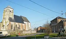 The church and town hall in Villers-sur-Authie | |
.svg.png.webp) Coat of arms | |
Location of Villers-sur-Authie | |
 Villers-sur-Authie 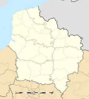 Villers-sur-Authie | |
| Coordinates: 50°19′03″N 1°41′39″E / 50.3175°N 1.6942°E | |
| Country | France |
| Region | Hauts-de-France |
| Department | Somme |
| Arrondissement | Abbeville |
| Canton | Rue |
| Intercommunality | CC Ponthieu-Marquenterre |
| Government | |
| • Mayor (2020–2026) | Michel Riquet[1] |
| Area 1 | 12.01 km2 (4.64 sq mi) |
| Population | 466 |
| • Density | 39/km2 (100/sq mi) |
| Time zone | UTC+01:00 (CET) |
| • Summer (DST) | UTC+02:00 (CEST) |
| INSEE/Postal code | 80806 /80120 |
| Elevation | 2–33 m (6.6–108.3 ft) (avg. 5 m or 16 ft) |
| 1 French Land Register data, which excludes lakes, ponds, glaciers > 1 km2 (0.386 sq mi or 247 acres) and river estuaries. | |
Villers-sur-Authie is a commune in the Somme department in Hauts-de-France in northern France.
Geography
The commune is situated 28 km (17 miles) north of Abbeville, on the D85 road.
Population
| Year | Pop. | ±% p.a. |
|---|---|---|
| 1968 | 420 | — |
| 1975 | 365 | −1.99% |
| 1982 | 379 | +0.54% |
| 1990 | 354 | −0.85% |
| 1999 | 362 | +0.25% |
| 2007 | 375 | +0.44% |
| 2012 | 433 | +2.92% |
| 2017 | 474 | +1.83% |
| Source: INSEE[3] | ||
Gallery
- Our Lady Church
.JPG.webp)
.JPG.webp)
.JPG.webp)
.JPG.webp)
.JPG.webp)
See also
References
- ↑ "Répertoire national des élus: les maires" (in French). data.gouv.fr, Plateforme ouverte des données publiques françaises. 13 September 2022.
- ↑ "Populations légales 2021". The National Institute of Statistics and Economic Studies. 28 December 2023.
- ↑ Population en historique depuis 1968, INSEE
Wikimedia Commons has media related to Villers-sur-Authie.
This article is issued from Wikipedia. The text is licensed under Creative Commons - Attribution - Sharealike. Additional terms may apply for the media files.