Adams, New Jersey | |
|---|---|
 Photo of Adams along Cozzens Lane | |
| Coordinates: 40°27′03″N 74°29′36″W / 40.45083°N 74.49333°W | |
| Country | |
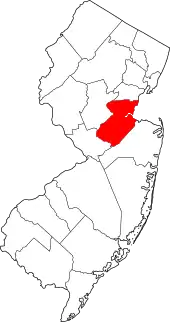
| State | |
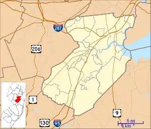
| County | Middlesex |
| Township | North Brunswick |
| Elevation | 115 ft (35 m) |
| GNIS feature ID | 874254[1] |
Adams is an unincorporated community located within North Brunswick Township in Middlesex County, in the U.S. state of New Jersey.[2] The community is located along Cozzens Lane (County Route 608) between Route 27 and U.S. Route 1. Except for commercial businesses lining Routes 1 and 27, the community is made up of mostly residential homes and apartment complexes.[3] The community once had a station known as Adams Station, along the Pennsylvania Railroad (currently the Northeast Corridor Line), located on Adams Lane, just east of Route 1.[4][5]
References
- 1 2 "Adams". Geographic Names Information System. United States Geological Survey, United States Department of the Interior.
- ↑ Locality Search, State of New Jersey. Accessed February 7, 2015.
- ↑ Google (May 17, 2015). "Aerial view of Adams" (Map). Google Maps. Google. Retrieved May 17, 2015.
- ↑ "Adams station, December 4, 1959". The Central New Jersey Home News. December 4, 1959. p. 18 – via newspapers.com.
- ↑ Moss, Adam (August 16, 2009). "English: The site of the former Adams Pennsylvania Railroad station in North Brunswick, New Jersey's Adams section. The station's staircases do remain along with the platform base" – via Wikimedia Commons.
This article is issued from Wikipedia. The text is licensed under Creative Commons - Attribution - Sharealike. Additional terms may apply for the media files.