Khulna Division
Khulna Division is one of the eight divisions of Bangladesh. It is in the southwest of the country. Almost 30 million people live there. Its headquarters is Khulna city in Khulna District.
Khulna Division | |
|---|---|
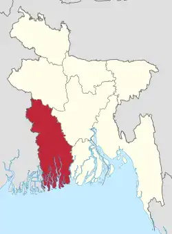 Map of Khulna Division | |
| Coordinates: 22°55′N 89°15′E | |
| Country | Bangladesh |
| Area | |
| • Total | 22,285 km2 (8,604 sq mi) |
| Population (2011 census) | |
| • Total | 15,563,000 |
| • Density | 700/km2 (1,800/sq mi) |
| Time zone | UTC+6 (BST) |
Geography
The Khulna division borders the Rajshahi Division to the north, the Dhaka Division to the northeast, Barisal Division to the east, the Bay of Bengal to the south and the state of West Bengal (in India) to the west. Barisal Division used to be part of Khulna Division.
Districts
Khulna Division consists of the following districts:
Economy
When part of East Pakistan's - Khulna provided most of the money from abroad due to the Jute industry. The country's second seaport, Mongla Port, and the country's only only ship building yard is in Khulna division.
The largest mangrove forest in the World the Sundarban is spread over the three districts of the division: Satkhira, Khulna and Bagherhat.
Related pages
| Barisal Division | 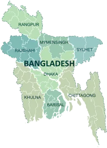 | |
|---|---|---|
| Chittagong Division |
Bandarban · Brahmanbaria · Chandpur · Chattogram · Comilla · Cox's Bazar · Feni · Khagrachari · Lakshmipur · Noakhali · Rangamati | |
| Dhaka Division |
Dhaka · Faridpur · Gazipur · Gopalganj · Kishoreganj · Madaripur · Manikganj · Munshiganj · Narayanganj · Narsingdi · Rajbari · Shariatpur · Tangail | |
| Mymensingh Division |
Mymensingh · Jamalpur · Sherpur · Netrokona · | |
| Khulna Division | ||
| Rajshahi Division | ||
| Rangpur Division |
Rangpur · Nilphamari · Dinajpur · Panchagarh · Gaibandha · Kurigram · Lalmonirhat · Thakurgaon | |
| Sylhet Division |
Habiganj · Maulvibazar · Sunamganj · Sylhet | |
| Disputed |
Chittagonian plains of Bangladesh (Tripura Division) | |