Mymensingh Division
Mymensingh Division is an administrative division of Bangladesh. The division has an area of 10,485 km², and a population of 11,370,000.
Mymensingh Division
ময়মনসিংহ বিভাগ | |
|---|---|
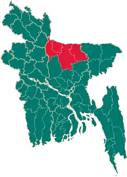 Map of Bangladesh showing Mymensingh Division | |
| Coordinates: 24°10′N 90°25′E | |
| Country | |
| Area | |
| • Total | 10,485 km2 (4,048 sq mi) |
| Population (2011 census) | |
| • Total | 11,370,000 |
| • Density | 1,100/km2 (2,800/sq mi) |
| Time zone | UTC+6 (BST) |
The division of Mymensingh is next to the Indian state of Meghalaya to the north, Dhaka Division on the south, Sylhet Division to the east, Rangpur and Rajshahi Division to the west.
| Barisal Division | 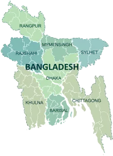 | |
|---|---|---|
| Chittagong Division |
Bandarban · Brahmanbaria · Chandpur · Chattogram · Comilla · Cox's Bazar · Feni · Khagrachari · Lakshmipur · Noakhali · Rangamati | |
| Dhaka Division |
Dhaka · Faridpur · Gazipur · Gopalganj · Kishoreganj · Madaripur · Manikganj · Munshiganj · Narayanganj · Narsingdi · Rajbari · Shariatpur · Tangail | |
| Mymensingh Division |
Mymensingh · Jamalpur · Sherpur · Netrokona · | |
| Khulna Division | ||
| Rajshahi Division | ||
| Rangpur Division |
Rangpur · Nilphamari · Dinajpur · Panchagarh · Gaibandha · Kurigram · Lalmonirhat · Thakurgaon | |
| Sylhet Division |
Habiganj · Maulvibazar · Sunamganj · Sylhet | |
| Disputed |
Chittagonian plains of Bangladesh (Tripura Division) | |
This article is issued from Wikipedia. The text is licensed under Creative Commons - Attribution - Sharealike. Additional terms may apply for the media files.