Ibaraki Prefecture
Ibaraki Prefecture (茨城県, Ibaraki-ken) is a prefecture in the Kantō region of Japan on the island of Honshu.[1] The capital is Mito.[2]
Ibaraki Prefecture
茨城県 | |
|---|---|
 Flag  Seal | |
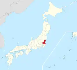 Ibaraki Prefecture in Japan | |
| Country | |
| Capital | Mito |
| Subdivisions | List
|
| Government | |
| • Governor | Kazuhiko Ōigawa |
| Area | |
| • Total | 6,097 km2 (2,354 sq mi) |
| Population (October 1, 2020) | |
| • Total | 2,867,009 |
| • Density | 470.2/km2 (1,218/sq mi) |
| Time zone | UTC+09:00 |
| Area code | 08000-4 |
| ISO 3166 code | JP-08 |
| Website | Official website |
History
In 1871, Ibaraki Prefecture was created from Hitachi Province.[3]
Geography

Ibaraki Prefecture is the northeastern part of Kantō. It is between Tochigi Prefecture and the Pacific Ocean. Fukushima Prefecture is its neighbor to the north and Chiba Prefecture is to the south. Saitama Prefecture is to the southwest. There are many mountains in the northern part of the prefecture. The rest of the prefecture is a flat plain with many lakes.
Cities
There are thirty-two cities in Ibaraki Prefecture:
Towns and villages
Towns and villages in each district:
|
|
|
National Parks
National Parks are established in about 15% of the total land area of the prefecture.[4]
Shrines and Temples
Kashima jinja are the chief Shinto shrines (ichinomiya) in the prefecture. [5]
Related pages
References
- Nussbaum, Louis-Frédéric. (2005). "Ibaraki-ken" in Japan Encyclopedia, p. 367; "Kantō" at p. 479.
- Nussbaum, "Mito" at p. 642.
- Nussbaum, "Provinces and prefectures" at p. 780.
- Japan Ministry of the Environment, "General overview of area figures for Natural Parks by prefecture"; retrieved 2012-3-14.
- "Nationwide List of Ichinomiya," p. 1 Archived 2013-05-17 at the Wayback Machine; retrieved 2012-3-14.
