Gunma Prefecture
Gunma Prefecture (群馬県, Gunma-ken) is a prefecture of in the Kantō region of Japan on the island of Honshu.[1] Its capital is Maebashi.[2]
Gunma Prefecture
群馬県 | |
|---|---|
 Flag  Seal | |
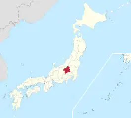 Gunma Prefecture in Japan | |
| Country | |
| Region | Kantō |
| Capital | Maebashi |
| Subdivisions | List
|
| Government | |
| • Governor | Ichita Yamamoto |
| Area | |
| • Total | 6,362 km2 (2,456 sq mi) |
| Population (October 1, 2020) | |
| • Total | 1,939,110 |
| • Density | 304.8/km2 (789/sq mi) |
| Time zone | UTC+09:00 (JST) |
| Postal code | 371-8570 |
| Area code | 10000-5 |
| ISO 3166 code | JP-10 |
| Website | Official website |
History
In the Meiji period, Gunma was created from land which was in Keno Province and Kōzuke Province.[3]
Geography
Gunma is in the northwestern part of the Kantō Plain. It is mostly mountainous.
Gunma shares northern borders with Niigata Prefecture and Fukushima Prefecture. The prefecture's eastern border is shared with Tochigi Prefecture. To the west lies Nagano Prefecture. Saitama Prefecture is south of the prefecture.
Cities
There are twelve cities in Gunma Prefecture:
|
|
|
Towns and villages
Towns and villages in each district:
|
|
|
National Parks
National Parks are established in about 14% of the total land area of the prefecture.[4]
Shrines and Temples
Ichinomiyanukisaki jinja is the chief Shinto shrines (ichinomiya) in the prefecture.[5]
Related pages
References
- Nussbaum, Louis-Frédéric. (2005). "Gumma-ken" in Japan Encyclopedia, p. 267; "Kantō" in p. 479.
- Nussbaum, "Maebashi" at p. 600.
- Nussbaum, "Provinces and prefectures" at p. 780.
- Japan Ministry of the Environment, "General overview of area figures for Natural Parks by prefecture"; retrieved 2012-3-13.
- "Nationwide List of Ichinomiya," p. 2 Archived 2013-05-17 at the Wayback Machine; retrieved 2012-3-14.
Other websites
- Official website
- Official website (Japanese)
