Choctaw County, Alabama
Choctaw County is a county of the U.S. state of Alabama. It was formed on December 29, 1847 and named for the Choctaw tribe of American Indians.[2] As of 2020 the population was 12,665.[1] The county seat is Butler.
Choctaw County | |
|---|---|
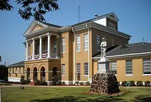 Choctaw County Courthouse and Confederate monument in Butler | |
 Location within the U.S. state of Alabama | |
 Alabama's location within the U.S. | |
| Coordinates: 32°01′13″N 88°15′47″W | |
| Country | |
| State | |
| Founded | December 29, 1847 |
| Named for | Choctaw tribe |
| Seat | Butler |
| Largest town | Butler |
| Area | |
| • Total | 921 sq mi (2,390 km2) |
| • Land | 914 sq mi (2,370 km2) |
| • Water | 7.4 sq mi (19 km2) 0.8% |
| Population | |
| • Total | 12,665 |
| • Density | 14/sq mi (5.3/km2) |
| Time zone | UTC−6 (Central) |
| • Summer (DST) | UTC−5 (CDT) |
Geography
According to the United States Census Bureau, the county has a total area of 921 square miles (2,390 km2), of which 914 square miles (2,370 km2) is land and 7.4 square miles (19 km2) (0.8%) is water.[3]
Major highways
 U.S. Highway 84
 State Route 10
 State Route 17
Border counties
- Sumter County (north)
- Marengo County (northeast)
- Clarke County (southeast)
- Washington County (south)
- Wayne County, Mississippi (southwest)
- Clarke County, Mississippi (west)
- Lauderdale County, Mississippi (northwest)
National protected area
- Choctaw National Wildlife Refuge
Settlements
Cities and towns
- Butler
- Gilbertown
- Lisman
- Needham
- Pennington
- Silas
- Toxey
Unincorporated communities
- Bladon Springs
- Jachin
- Mount Sterling
- Pushmataha
- Yantley
References
- "QuickFacts: Choctaw County, Alabama". United States Census Bureau. Retrieved August 8, 2023.
- "Alabama Counties: Choctaw County". Alabama Department of Archives and History. Retrieved June 21, 2011.
- "2010 Census Gazetteer Files". United States Census Bureau. August 22, 2012. Retrieved August 22, 2015.
Municipalities and communities of Choctaw County, Alabama, United States | ||
|---|---|---|
| Towns |
| Map of Alabama highlighting Choctaw County |
| CDP |
| |
| Unincorporated communities |
| |
| Footnotes | ‡This populated place also has portions in an adjacent county or counties | |
This article is issued from Wikipedia. The text is licensed under Creative Commons - Attribution - Sharealike. Additional terms may apply for the media files.