Bullock County, Alabama
Bullock County, Alabama is a county of the U.S. state of Alabama. Its name is in honor of Colonel Edward C. Bullock of Barbour County. As of 2020 the population was 10,357.[1]
Bullock County | |
|---|---|
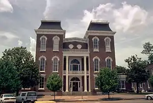 Bullock County courthouse in Union Springs | |
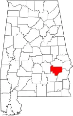 Location within the U.S. state of Alabama | |
 Alabama's location within the U.S. | |
| Coordinates: 32°05′52″N 85°43′02″W | |
| Country | |
| State | |
| Founded | December 5 (created), 1866 |
| Named for | Edward Bullock |
| Seat | Union Springs |
| Largest city | Union Springs |
| Area | |
| • Total | 625 sq mi (1,620 km2) |
| • Land | 623 sq mi (1,610 km2) |
| • Water | 2.3 sq mi (6 km2) 0.4% |
| Population | |
| • Total | 10,357 |
| • Density | 17/sq mi (6.4/km2) |
| Time zone | UTC−6 (Central) |
| • Summer (DST) | UTC−5 (CDT) |
| Website | bullockcountyalrev |
History
Bullock County was formed on December 5, 1866. The boundaries were changed in February 1867. In 1867, Union Springs was chosen as the county seat.
Geography
According to the United States Census Bureau, the county has a total area of 625 square miles (1,620 km2), of which 623 square miles (1,610 km2) is land and 2.3 square miles (6.0 km2) (0.4%) is water.[2] The county is in the southeastern section of the state, in the prairie region. The Chunnennuggee Ridge runs through the center of the county.
Incorporated cities and towns
Unincorporated communities
- Fitzpatrick
- Inverness
- Perote
- Smut Eye (sometimes Smuteye)
- Thompson
Adjacent counties
- Macon County (north)
- Russell County (northeast)
- Barbour County (southeast)
- Pike County (southwest)
- Montgomery County (west)
Transportation
Major highways
 U.S. Highway 29
 U.S. Highway 82
 State Route 51
 State Route 110
Airport
Franklin Field is a county-owned public-use airport. It is located five nautical miles (9 km) west of the central business district of Union Springs, Alabama.[3]
Places of interest
Bullock County is home to several historic homes including the McCaslan-Garner House and Bonus-Foster-Chapman House.
References
- "QuickFacts: Bullock County, Alabama". United States Census Bureau. Retrieved August 8, 2023.
- "2010 Census Gazetteer Files". United States Census Bureau. August 22, 2012. Retrieved August 22, 2015.
- FAA Airport Master Record for 07A (Form 5010 PDF). Federal Aviation Administration. Effective 3 June 2010.
- Owen, Thomas McAdory. History of Alabama and Dictionary of Alabama Biography. Chicago: S.J. Clarke Publishing Co., 1921.
Municipalities and communities of Bullock County, Alabama, United States | ||
|---|---|---|
| Cities | Map of Alabama highlighting Bullock County | |
| Towns | ||
| CDP |
| |
| Unincorporated communities |
| |
| Ghost towns |
| |