Andaman and Nicobar Islands
The Andaman and Nicobar Islands are a union territory of India. The name is often shortened to A & N Islands, or ANI.
Andaman and Nicobar Islands | |
|---|---|
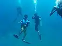   (clockwise from top) Barren Island, Beach at Ross and Smith island; Sunset at Andaman Island; Diving in Andamans | |
 Emblem | |
 Location of Andaman and Nicobar Islands in India | |
| Coordinates (Port Blair): 11.68°N 92.77°E | |
| Country | |
| Established | 1 November 1956 |
| Capital and largest city | Port Blair |
| Districts | 3 |
| Government | |
| • Lieutenant Governor | Admiral (Retd.) Devendra Kumar Joshi |
| • Chief Secretary | Chetan Bhushan Sanghi, IAS |
| • Lok Sabha Constituency 1 | Shri. Kuldeep Rai Sharma INC |
| • High Court | Calcutta High Court - Port Blair Bench |
| Area | |
| • Total | 8,249 km2 (3,185 sq mi) |
| • Rank | 28th |
| Population (2012)[2] | |
| • Total | 380,520 |
| • Density | 46/km2 (120/sq mi) |
| Languages[3] | |
| • Official | Hindi, English[3] |
| • Spoken | Bengali, Hindi, Tamil, Telugu, Malayalam, Nicobarese, Kurukh, Munda, Kharia[4] |
| Time zone | UTC+05:30 (IST) |
| ISO 3166 code | IN-AN |
| HDI (2019) | |
| Website | www |
| Symbols of Andaman and Nicobar Islands | |
| Emblem | Emblem of Andaman and Nicobar Islands |
| Motto | Satyameva Jayate (Truth alone triumphs) |
| Mammal | Dugong |
| Bird | Andaman Wood Pigeon |
| Flower | Lagerstroemia speciosa Pyinma |
| Tree |  |
The islands are in the Indian Ocean, in the southern part of the Bay of Bengal. The capital of this territory is the Andamanese town of Port Blair.
It is made of two island groups - the Andaman Islands and the Nicobar Islands - separating the Andaman Sea to the east, from the Indian Ocean. These two groups are separated by the 10° N parallel, the Andamans lying to the north of this latitude, and the Nicobars to the south. The channel that separates ANI is the 10° degree channel. This islands have the only active volcano in India, Barren Island. These islands are also uninhabitated. It also has the lowest point in India, The Indira Point
The territory's population in the last (2001) census of India was 356,152. Added together, the total land area of the territory is around 6,496 km² or 2,508 mi², it is larger than the Palestinian territories but smaller than Georgia territory of Abkhazia.
Territorial symbols of Andaman and Nicobar
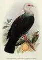 Columba palumboides, provincial bird
 Manatee, provincial animal
 Phalaenopsis speciosa, provincial flower
 Pterocarpus dalbergioides, provincial tree
References
- "Andaman and Nicobar Administration". And.nic.in. Archived from the original on 18 February 2015. Retrieved 8 July 2013.
- Census of India Archived 14 June 2007 at the Wayback Machine, 2011. Census Data Online, Population.
- "50th Report of the Commissioner for Linguistic Minorities in India" (PDF). 16 July 2014. p. 109. Archived from the original (PDF) on 22 March 2015. Retrieved 6 November 2016.
- "www.andaman.gov.in". Archived from the original on 20 November 2016. Retrieved 27 November 2016.
| States |
Andhra Pradesh • Arunachal Pradesh • Assam • Bihar • Chhattisgarh • Goa • Gujarat • Haryana • Himachal Pradesh • Jharkhand • Karnataka • Kerala • Madhya Pradesh • Maharashtra • Manipur • Meghalaya • Mizoram • Nagaland • Odisha • Punjab • Rajasthan • Sikkim • Tamil Nadu • Telangana • Tripura • Uttar Pradesh • Uttarakhand • West Bengal | |
|---|---|---|
| Union Territories | ||