Tisová | |
|---|---|
 Municipal office | |
 Flag  Coat of arms | |
 Tisová Location in the Czech Republic | |
| Coordinates: 49°56′10″N 16°13′29″E / 49.93611°N 16.22472°E | |
| Country | |
| Region | Pardubice |
| District | Ústí nad Orlicí |
| First mentioned | 1407 |
| Area | |
| • Total | 10.97 km2 (4.24 sq mi) |
| Elevation | 292 m (958 ft) |
| Population (2023-01-01)[1] | |
| • Total | 602 |
| • Density | 55/km2 (140/sq mi) |
| Time zone | UTC+1 (CET) |
| • Summer (DST) | UTC+2 (CEST) |
| Postal code | 566 01 |
| Website | www |
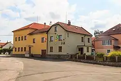
Tisová (German: Tisau) a municipality and village in Ústí nad Orlicí District in the Pardubice Region of the Czech Republic. It has about 600 inhabitants.
Tisová lies approximately 14 kilometres (9 mi) west of Ústí nad Orlicí, 34 kilometres (21 mi) east of Pardubice, and 130 kilometres (81 mi) east of Prague.
Administrative parts
The village of Zaháj is an administrative part of Tisová.
References
Wikimedia Commons has media related to Tisová (Ústí nad Orlicí District).
This article is issued from Wikipedia. The text is licensed under Creative Commons - Attribution - Sharealike. Additional terms may apply for the media files.