Těchonín | |
|---|---|
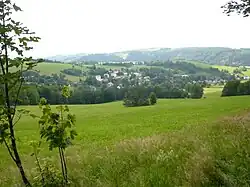 General view | |
 Flag  Coat of arms | |
 Těchonín Location in the Czech Republic | |
| Coordinates: 50°3′54″N 16°37′5″E / 50.06500°N 16.61806°E | |
| Country | |
| Region | Pardubice |
| District | Ústí nad Orlicí |
| First mentioned | 1543 |
| Area | |
| • Total | 18.99 km2 (7.33 sq mi) |
| Elevation | 494 m (1,621 ft) |
| Population (2023-01-01)[1] | |
| • Total | 593 |
| • Density | 31/km2 (81/sq mi) |
| Time zone | UTC+1 (CET) |
| • Summer (DST) | UTC+2 (CEST) |
| Postal code | 561 66 |
| Website | www |
Těchonín (German: Linsdorf) is a municipality and village in Ústí nad Orlicí District in the Pardubice Region of the Czech Republic. It has about 600 inhabitants.
Administrative parts
Villages of Celné and Stanovník are administrative parts of Těchonín.
Economy
A BSL-4 biosafety facility, Centre of Biological Protection, is located here.[2]
References
External links
Wikimedia Commons has media related to Těchonín.
This article is issued from Wikipedia. The text is licensed under Creative Commons - Attribution - Sharealike. Additional terms may apply for the media files.