Tatenice | |
|---|---|
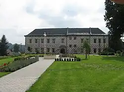 Tatenice Castle | |
 Flag  Coat of arms | |
 Tatenice Location in the Czech Republic | |
| Coordinates: 49°52′16″N 16°41′50″E / 49.87111°N 16.69722°E | |
| Country | |
| Region | Pardubice |
| District | Ústí nad Orlicí |
| First mentioned | 1267 |
| Area | |
| • Total | 26.82 km2 (10.36 sq mi) |
| Elevation | 344 m (1,129 ft) |
| Population (2023-01-01)[1] | |
| • Total | 886 |
| • Density | 33/km2 (86/sq mi) |
| Time zone | UTC+1 (CET) |
| • Summer (DST) | UTC+2 (CEST) |
| Postal code | 561 31 |
| Website | www |
Tatenice (German: Tattenitz) is a municipality and village in Ústí nad Orlicí District in the Pardubice Region of the Czech Republic. It has about 900 inhabitants.
Tatenice lies approximately 25 kilometres (16 mi) south-east of Ústí nad Orlicí, 69 km (43 mi) east of Pardubice, and 165 km (103 mi) east of Prague.
References
Wikimedia Commons has media related to Tatenice.
This article is issued from Wikipedia. The text is licensed under Creative Commons - Attribution - Sharealike. Additional terms may apply for the media files.